Kemp Land
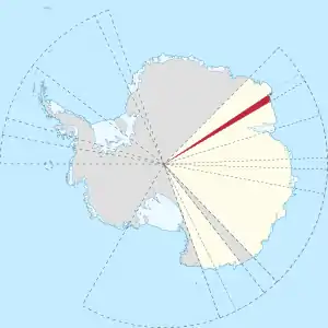
Kemp Land is a thin sliver of Antarctica including, and lying inland from, the Kemp Coast. Part of the Australian Antarctic claim it is defined as lying between 56° 25' E and 59° 34' E, and, as with other sectors of the Antarctic, is deemed as being limited by the 60° S parallel. It is bounded in the east by Mac. Robertson Land and in the west by Enderby Land. Kemp Land includes one major group of islands, the Øygarden Group.[1]

Location of Kemp Land (red), Australian Antarctic Territory in Antarctica
Exploration
Named after Peter Kemp, who, in the brig Magnet, is reported to have sighted land in 1833.[3] In 1930, BANZARE under Sir Douglas Mawson in the Discovery delineated the coastline from the junction with Enderby Land to that with Mac. Robertson Land. In 1936 the coast was recharted by RRS William Scoresby.[1]
Further reading
• Anna Bemrose, Mawson's Last Survivor: The Story of Dr Alf Howard , PP 3, 82, 89
References
- Kemp Land on SCAR website
- geographical information about Kemp Land
- Jones, A. G. E. (August 1968). "Captain Peter Kemp and Kemp Land". Society for Nautical Research. Retrieved 24 September 2019.
This article is issued from Wikipedia. The text is licensed under Creative Commons - Attribution - Sharealike. Additional terms may apply for the media files.
