Kenmar, Pennsylvania
Kenmar is a census-designated place (CDP) in Loyalsock Township, Lycoming County, Pennsylvania, United States.[3] As of the 2010 census, it had a population of 4,124.[2] Kenmar is not a separately incorporated community, but is a part of Loyalsock Township (which is a municipality under Pennsylvania law).
Kenmar, Pennsylvania | |
|---|---|
 Kenmar  Kenmar | |
| Coordinates: 41°15′12″N 76°57′33″W | |
| State | Pennsylvania |
| County | Lycoming |
| Township | Loyalsock |
| Area | |
| • Total | 2.06 sq mi (5.33 km2) |
| • Land | 2.05 sq mi (5.31 km2) |
| • Water | 0.008 sq mi (0.02 km2) |
| Elevation | 530 ft (160 m) |
| Population | |
| • Total | 4,124 |
| • Density | 2,013/sq mi (777.3/km2) |
| Time zone | UTC-5 (Eastern (EST)) |
| • Summer (DST) | UTC-4 (EDT) |
| Area code(s) | 570 |
| FIPS code | 42-39280 |
| GNIS feature ID | 1192706 |
Kenmar is bordered by Four Mile Drive to the north, Miller Run and the CDP of Faxon to the west, Interstate 180 to the south, and Loyalsock Creek and the borough of Montoursville to the east.[4]
Kenmar is east of Faxon; there was a previous CDP named "East Faxon" in Lycoming County, but it lost its status as a CDP in the 1990 Census.[5]
References
- "2019 U.S. Gazetteer Files". United States Census Bureau. Retrieved December 16, 2020.
- "Total Population: 2010 Census DEC Summary File 1 (P1), Kenmar CDP, Pennsylvania". data.census.gov. U.S. Census Bureau. Retrieved December 16, 2020.
- U.S. Geological Survey Geographic Names Information System: Kenmar Census Designated Place
- 2011 BOUNDARY AND ANNEXATION SURVEY (BAS): Lycoming County, PA (PDF) (Map). United States Department of Commerce, Bureau of the Census. 2011. Archived from the original (PDF) on July 21, 2011. Retrieved February 13, 2011.
- 1990 Census of Population and Housing: Population and Housing Unit Counts, Pennsylvania. United States Department of Commerce, Bureau of the Census. 1992. p. III-2. Retrieved February 13, 2011.
Municipalities and communities of Lycoming County, Pennsylvania, United States | ||
|---|---|---|
| City | 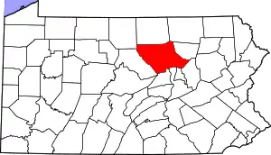 | |
| Boroughs | ||
| Townships |
| |
| CDPs | ||
| Unincorporated communities | ||
| Ghost town | ||
| Footnotes | ‡This populated place also has portions in an adjacent county | |
| ||
This article is issued from Wikipedia. The text is licensed under Creative Commons - Attribution - Sharealike. Additional terms may apply for the media files.