Kentucky Route 156
Kentucky Route 156 (KY 156) is a 7.813-mile-long (12.574 km) state highway in Fleming County, Kentucky. It runs from KY 11 southwest of Flemingsburg to KY 32 southeast of Flemingsburg.
| ||||
|---|---|---|---|---|
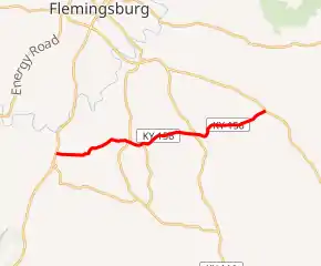
KY 156 highlighted in red | ||||
| Route information | ||||
| Maintained by KYTC | ||||
| Length | 7.813 mi[1] (12.574 km) | |||
| Major junctions | ||||
| West end | ||||
| East end | ||||
| Location | ||||
| Counties | Fleming | |||
| Highway system | ||||
| ||||

Major intersections
The entire route is in Fleming County.
| Location | mi[1] | km | Destinations | Notes | |
|---|---|---|---|---|---|
| | 0.000 | 0.000 | Western terminus | ||
| | 0.215 | 0.346 | |||
| Bald Hill | 2.694 | 4.336 | |||
| | 3.183 | 5.123 | Northern terminus of KY 1515 | ||
| Poplar Plains | 5.038 | 8.108 | |||
| | 7.813 | 12.574 | Eastern terminus | ||
| 1.000 mi = 1.609 km; 1.000 km = 0.621 mi | |||||
References
- "Official DMI Route Log". Kentucky Transportation Cabinet. Retrieved July 3, 2015.
This article is issued from Wikipedia. The text is licensed under Creative Commons - Attribution - Sharealike. Additional terms may apply for the media files.