Kentucky Route 20
Kentucky Route 20 (KY 20) is a 20.725-mile-long (33.354 km) state highway in Kentucky that runs from KY 18 north of Belleview to the middle segment of KY 8.
| ||||
|---|---|---|---|---|
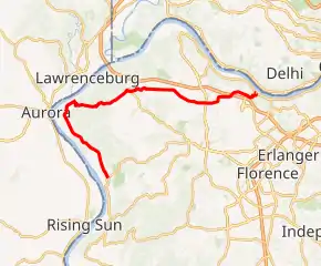
KY 20 highlighted in red | ||||
| Route information | ||||
| Maintained by KYTC | ||||
| Length | 20.725 mi[1] (33.354 km) | |||
| Major junctions | ||||
| West end | ||||
| East end | ||||
| Location | ||||
| Counties | Boone | |||
| Highway system | ||||
| ||||

Route description
KY 20 begins heading northwest. Near Petersburg, it heads northeast, before turning to the east in Petersburg. KY 20 meets the western segment of KY 8 and provides access to Interstate 275 west. KY 20 merges to the right and passes through Idlewild. KY 20 meets KY 212 just north of the Cincinnati-Northern Kentucky Airport. KY 212 provides access to Interstate 275 east. KY 20 passes over Interstate 275 but does not have direct access. KY 20 descends into the Ohio Valley and comes to an end at the middle segment of KY 8 west of Villa Hills.
Major intersections
The entire route is in Boone County.
| Location | mi[1] | km | Destinations | Notes | |
|---|---|---|---|---|---|
| Belleview | 0.000 | 0.000 | |||
| Idlewild | 10.873 | 17.498 | |||
| 11.221 | 18.058 | ||||
| Hebron | 16.620 | 26.747 | |||
| 19.708 | 31.717 | ||||
| 20.725 | 33.354 | ||||
| 1.000 mi = 1.609 km; 1.000 km = 0.621 mi | |||||
References
This article is issued from Wikipedia. The text is licensed under Creative Commons - Attribution - Sharealike. Additional terms may apply for the media files.