Keren, Eritrea
Keren (ከረን) and historically known as Sanhit,[2] is the second-largest city in Eritrea. It is situated around 91 kilometres (57 mi) northwest of Asmara at an elevation of 1,390 metres (4,560 ft) above sea-level. The city sprawls on a wide basin surrounded by granitic mountains on all sides. It serves as the capital of the Anseba region, and is home to a number of ethnic groups including the Bilen people, Tigre people and Tigrinya people.
Keren
Keren | |
|---|---|
City | |
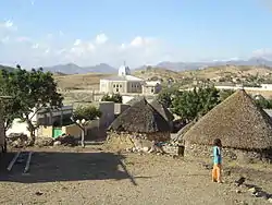
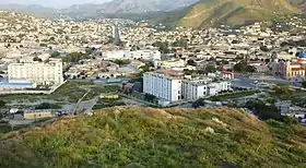 .jpg.webp) .jpg.webp) 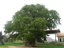 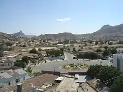 Left to right from top: Cityscape, Sarina Hotel, Spice and soap vendor, Mariam Dearit, View of the city | |
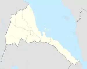 Keren Location in Eritrea | |
| Coordinates: 15°46′40″N 38°27′29″E | |
| Country | Eritrea |
| Region | Anseba |
| District | Keren |
| Elevation | 1,590 m (5,220 ft) |
| Population (2016) | |
| • City | 120,000[1] |
| • Metro | 146,483 |
History
Keren grew around the Eritrean Railway to Asmara. The railway was later dismantled because of the war, although there are plans to rebuild it. It is an important commercial centre and was the scene of regular battles in both World War II and the Eritrean War of Independence. Keren was the site of a key battle between Italian and British troops in February – March 1941.
Demographics
As of 2016, Keren has a population of around 120,000 inhabitants. Residents belong to various, mainly Afroasiatic-speaking ethnic groups, of which the Bilen people, Tigre people and Tigrinya people predominant.
Climate
Keren has a hot semi-arid climate (Köppen BSh), with two main seasons. There is a short monsoonal wet season from June to September and a length dry season covering the rest of the year. Vis-à-vis most hot semi-arid climates in northern Africa like those of Niamey or N'Djamena, Keren's climate is much less extreme due to the city's higher altitude. Nonetheless, in the period between March and mid-June immediately before the wet season begins, afternoon temperatures still average over 33.1 °C (92 °F) for around four months. Following the wet season, temperatures remain very warm to hot during the day, but during the mornings become comfortably cool.
| Climate data for Keren | |||||||||||||
|---|---|---|---|---|---|---|---|---|---|---|---|---|---|
| Month | Jan | Feb | Mar | Apr | May | Jun | Jul | Aug | Sep | Oct | Nov | Dec | Year |
| Average high °C (°F) | 28.4 (83.1) |
29.5 (85.1) |
31.3 (88.3) |
33.5 (92.3) |
34.6 (94.3) |
33.1 (91.6) |
28.9 (84.0) |
27.6 (81.7) |
30.4 (86.7) |
31.4 (88.5) |
29.8 (85.6) |
28.8 (83.8) |
30.6 (87.1) |
| Daily mean °C (°F) | 12.6 (54.7) |
13.1 (55.6) |
15.1 (59.2) |
16.8 (62.2) |
17.9 (64.2) |
17.8 (64.0) |
17.6 (63.7) |
17.1 (62.8) |
16.1 (61.0) |
15.9 (60.6) |
15.0 (59.0) |
13.6 (56.5) |
15.7 (60.3) |
| Average low °C (°F) | 7.0 (44.6) |
7.7 (45.9) |
8.8 (47.8) |
10.5 (50.9) |
12.2 (54.0) |
14.4 (57.9) |
16.6 (61.9) |
16.1 (61.0) |
13.8 (56.8) |
11.6 (52.9) |
9.4 (48.9) |
8.3 (46.9) |
11.4 (52.5) |
| Average rainfall mm (inches) | 1 (0.0) |
1 (0.0) |
3 (0.1) |
14 (0.6) |
27 (1.1) |
44 (1.7) |
119 (4.7) |
142 (5.6) |
42 (1.7) |
11 (0.4) |
6 (0.2) |
1 (0.0) |
411 (16.1) |
| Source: Climate-Data[3] | |||||||||||||
Attractions
Attractions in the city include the nineteenth century Tigu Egyptian fort, the St Maryam Deari chapel, lying in a baobab tree, the 1920s former railway station, the old mosque, Sayed Bakri Mausoleum, British Army and Italian Army cemeteries and local markets. The nearby sixth century Debre Sina monastery is also known for its cave dwellings.
.jpg.webp)
Districts
The town's outlying subregions include:
- Elabered
- Geleb Subregion
- Hagaz (Hagat)
- Halhal
- Melabso
References
- https://www.aljazeera.com/indepth/inpictures/2016/03/everyday-eritrea-resilience-face-repression-160310083414592.html
- Shinn, David & al. "Hewitt Treaty" in the Historical Dictionary of Ethiopia, p. 214.
- "Climate-Data : Eritrea". Retrieved 11 July 2013.
Further reading
| Wikimedia Commons has media related to Keren. |
| Wikivoyage has a travel guide for Keren. |
- Hill, Justin (2002), Ciao Asmara, A classic account of contemporary Africa. Little, Brown, ISBN 978-0-349-11526-9. VSO volunteer's story of Eritrea. Hill lived in Keren for two years
- The Globalist Feature, including an extract from Justin Hill's book, Ciao Asmara.
| Authority control |
|---|