Keri, Greece
Keri (Greek: Κερί) is a village and a community in the southern part of the island of Zakynthos. It is situated on a hillside, close to the Ionian Sea coast. Its population in 2011 was 469 for the village and 788 for the community, which includes the villages Apelati, Limni Keriou and Marathias. The community includes the island's southernmost point, Cape Marathia. Keri is 6 km south of Lithakia and 15 km southwest of Zakynthos (city). The village suffered great damage from the 1953 Ionian earthquake.
Keri
Κερί | |
|---|---|
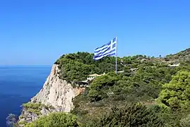 "The biggest Greek flag" above the Fanari cliffs | |
 Keri | |
| Coordinates: 37°40′N 20°49′E | |
| Country | Greece |
| Administrative region | Ionian Islands |
| Regional unit | Zakynthos |
| Municipality | Zakynthos |
| Municipal unit | Laganas |
| Population (2011)[1] | |
| • Rural | 469 |
| Community | |
| • Population | 788 (2011) |
| Time zone | UTC+2 (EET) |
| • Summer (DST) | UTC+3 (EEST) |
Keri is also famous for nearby Keri cliffs, rising over 300 m from the Ionian Sea. This location is famous for its sunset.[2] A 9-metre tall lighthouse, built in 1925, sits atop the cliffs.[3]
Population
| Year | Population village | Population community |
|---|---|---|
| 1981 | 663 | - |
| 1991 | 572 | - |
| 2001 | 487 | 680 |
| 2011 | 469 | 788 |
See also
References
- "Απογραφή Πληθυσμού - Κατοικιών 2011. ΜΟΝΙΜΟΣ Πληθυσμός" (in Greek). Hellenic Statistical Authority.
- Nick Edwards; John Gill (2003). The Ionian Islands. Rough Guides. pp. 246–. ISBN 978-1-84353-067-1.
- "Lighthouse Keri". Greek Travel Pages.
External links
| Wikimedia Commons has media related to Keri (Zakynthos). |
This article is issued from Wikipedia. The text is licensed under Creative Commons - Attribution - Sharealike. Additional terms may apply for the media files.