Kettering Borough Council
Kettering Borough Council is a local authority in Kettering Borough, composed of 36 local councillors and currently controlled by the Conservatives, who have controlled the Council since the 2003 local elections, where they gained control from Labour with a majority of 15. Having retained control in the 2015 local elections, the Council is currently led by Cllr. Russell Roberts.
| Kettering Borough Council | |
|---|---|
 | |
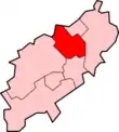 Shown within Northamptonshire |
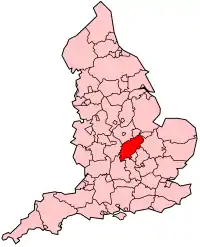 Northamptonshire within England |
| Geography | |
| Status: | Borough |
| Region: | East Midlands |
| Admin. County: | Northamptonshire |
| Admin. HQ: | Kettering |
| Leadership | |
| Council Type: | Leader & Cabinet |
| Control: | Conservative (since 2003) |
| Leader: | Cllr. Russell Roberts (since 2011) |
| MP: | Philip Hollobone (since 2005) |
Kettering Borough Council was established in 1973, as part of reforms marked by the Local Government Act 1972. Prior to this date, Kettering Borough was represented by the Urban District Councils of Burton Latimer, Desborough, Rothwell and Kettering (wholly within the current Borough boundaries) and the Rural District Council of Kettering Rural (mainly within the current Borough boundaries).
| Year | Conservative | Labour Party | Independent | Liberal Democrats |
|---|---|---|---|---|
| 2016 | 26 | 7 | 2 | 1 |
History
- 2003-Present: Conservative controlled
- 2001-2003-: Labour controlled (due to a by-election gain in St. Michael's Ward)
- 1999-2001: No Overall Control (Labour minority administration)
- 1995-1999: Labour controlled
- 1987-1995: No Overall Control
- 1983-1987: Conservative controlled
- 1973-1983: No Overall Control
Elections
Ordinary Elections
- 2007 Elections (Conservative hold)
- 2003 Elections (Conservative gain from Labour)
- 1999 Elections (No Overall Control gain from Labour)
- 1995 Elections (Labour gain from No Overall Control)
- 1991 Elections (No Overall Control hold)
- 1987 Elections (No Overall Control gain from Conservative)
- 1983 Elections (Conservative gain from No Overall Control)
- 1979 Elections (No Overall Control hold)
- 1976 Elections (No Overall Control hold)
- 1973 Elections (No Overall Control win)
By-elections (2003 – present)
- St. Mary's Ward by-election: 17 November 2005 (Labour hold)
- Wicksteed Ward by-election: 6 October 2005 (Labour gain from Conservative)
- Latimer Ward by-election (Burton Latimer): 28 July 2005 (Conservative hold)
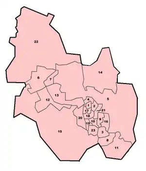
Wards and Councillors
2007 - Present
Since boundary changes implemented for the 2007 local elections, the wards of Kettering Borough Council have been as follows:
| Ward | Council seats | Current party (As at November 2010) |
|---|---|---|
| All Saints | 3 seats | 1 Con, 2 Lab |
| Avondale Grange | 2 seats | 2 Lab |
| Barton | 2 seats | 2 Con |
| Brambleside | 2 seats | 2 Con |
| Burton Latimer | 3 seats | 2 Ind, 1 Con |
| Desborough Loatland | 2 seats | 2 Con |
| Desborough St Giles | 2 seats | 2 Con |
| Ise Lodge | 3 seats | 3 Con |
| Northfield | 1 seat | 1 Lab |
| Piper's Hill | 2 seats | 2 Con |
| Queen Eleanor & Buccleuch | 1 seat | 1 Con |
| Rothwell | 3 seats | 3 Con |
| Slade | 2 seats | 2 Con |
| St Michael's & Wicksteed | 3 seats | 3 Con |
| St Peter's | 2 seats | 2 Con |
| Welland | 1 seat | 1 Con |
| William Knibb | 2 seats | 2 Con |
| TOTAL | 36 seats | 28 Con, 6 Lab, 2 Ind |
1999 - 2007
For the elections held in May 1999 and May 2003, the wards of Kettering Borough Council were as follows:
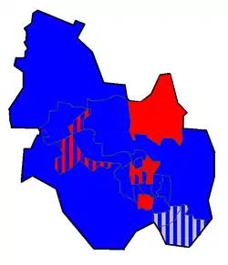
(Key: Red = Labour, Blue = Conservative, Grey = Independent, Stripes = Mixed Ward)
| Ward | Council seats |
|---|---|
| All Saints | 2 seats |
| Avondale | 2 seats |
| Barton | 2 seats |
| Brambleside | 2 seats |
| Buccleuch | 1 seat |
| Latimer (Burton Latimer) | 2 seats |
| Loatland (Desborough) | 2 seats |
| Millbrook | 2 seats |
| Piper's Hill | 2 seats |
| Plessy (Burton Latimer) | 2 seats |
| Queen Eleanor | 1 seat |
| Slade | 2 seats |
| Spinney | 2 seats |
| St Andrew's | 3 seats |
| St Giles (Desborough) | 2 seats |
| St Mary's | 3 seats |
| St Michael's | 2 seats |
| St Peter's | 2 seats |
| Tresham (Rothwell) | 2 seats |
| Trinity (Rothwell) | 2 seats |
| Warkton | 2 seats |
| Welland | 1 seat |
| Wicksteed | 2 seats |
| TOTAL | 45 seats |