Keystone Heights, Florida
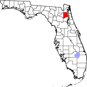
Keystone Heights is a city located in southwestern Clay County, Florida, United States. The population of the city was 1,350 at the 2010 census.[5]
Keystone Heights, Florida | |
|---|---|
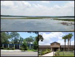
 Images top, left to right: Lake Geneva, City Hall, Keystone Heights Junior/Senior High School | |
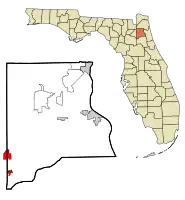
 Location in Clay County and the state of Florida | |
| Coordinates: 29°47′14″N 82°1′59″W | |
| Country | |
| State | |
| County | Clay |
| Area | |
| • Total | 1.09 sq mi (2.82 km2) |
| • Land | 1.07 sq mi (2.78 km2) |
| • Water | 0.01 sq mi (0.04 km2) |
| Elevation | 141 ft (43 m) |
| Population (2010) | |
| • Total | 1,350 |
| • Estimate (2019)[2] | 1,537 |
| • Density | 1,429.77/sq mi (552.22/km2) |
| Time zone | UTC-5 (Eastern (EST)) |
| • Summer (DST) | UTC-4 (EDT) |
| ZIP code | 32656 |
| Area code(s) | 352 |
| FIPS code | 12-36475[3] |
| GNIS feature ID | 0285088[4] |
| Website | www |
History
In 1917, the area that would eventually become known as the city of Keystone Heights was a small community known as Brooklyn located along present day State Road 100, about one mile north of the present location of Keystone Heights on Lake Brooklyn.[6]
In those early days Brooklyn consisted of a large unpainted building called the Brooklyn Hotel; a combination general store and post office; and several small houses scattered about. Property Developer John J. Lawrence, who hailed from Pennsylvania, noticed the area on a visit to Lake Brooklyn, and instantly became attracted to the region.[6]
In 1920, the Lawrence family completed their home, the first house built in Keystone Heights, which overlooked Lake Geneva, and still lies there today at the corner of Jasmine Street & Lawrence Blvd. (State Road 21). The town would be incorporated as Keystone Heights, named after Lawrence's home state of Pennsylvania's nickname, the "Keystone" state, in 1924.[6]
After hearing of natural wonders and the many different lakes of the area, other families moved to Keystone, putting a strain on those attempting to build structures within the city. Helping to address the issue, in late 1921, C. Ray Lawrence came to Keystone Heights, and began laying out the streets and lots in the town.[6]
The next particularly significant event happened on New Year's Day in 1923, when the Keystone Inn opened. The inn hosted many events throughout the community, and became an icon for the town.[6]
Tourists visiting the inn would often also frequent the Chautauqua. A large open pit that effectively served as a type of amphitheater, the Chautauqua served as a beacon for various musicians, artists, and speakers from the Chautauqua circuit in New York.[6]
Within two years, people were traveling to the Keystone Inn and the community of Keystone Heights from great distances to experience the town for themselves. The small community boasted a public beach with a pavilion, picnic grounds and a nine-hole golf course. The University of Florida's football team would stay at the inn before their homecoming games.[6]
The inn no longer exists. It burned in October 1954, and was never rebuilt. Today, the former property of the inn is a park in front of City Hall.[6]
The city gained the Keystone Heights school in 1925. As the city rapidly grew, the school began to expand as well, and in 1963, Keystone Heights High School and Keystone Heights Elementary were established on the property of what is today the elementary school. In September 1974, the high school moved to its present-day location across the street, and became Keystone Heights Junior/Senior High School.[6]
Geography
Keystone Heights is located in northeast Florida in the southwest corner of Clay County, at 29°47′14″N 82°1′59″W (29.787243, -82.033026).[7] The city overlooks the north shore of Lake Geneva. State Road 21 leads northeast 30 miles (48 km) (via SR 16 to Green Cove Springs, the Clay County seat, and south 18 miles (29 km) to Hawthorne. SR 100 crosses SR 21 and leads north 12 miles (19 km) to Starke and southeast 26 miles (42 km) to Palatka.
According to the United States Census Bureau, the city has a total area of 1.1 square miles (2.9 km2), of which 0.012 square miles (0.03 km2), or 1.16%, is water.[5]
Demographics
| Historical population | |||
|---|---|---|---|
| Census | Pop. | %± | |
| 1930 | 107 | — | |
| 1940 | 145 | 35.5% | |
| 1950 | 307 | 111.7% | |
| 1960 | 655 | 113.4% | |
| 1970 | 800 | 22.1% | |
| 1980 | 1,056 | 32.0% | |
| 1990 | 1,315 | 24.5% | |
| 2000 | 1,349 | 2.6% | |
| 2010 | 1,350 | 0.1% | |
| 2019 (est.) | 1,537 | [2] | 13.9% |
| U.S. Decennial Census[8] | |||
As of the census[3] of 2000, there were 1,349 people, 515 households, and 374 families residing in the city. The population density was 296.9 people per square mile (114.7/km2). There were 562 housing units at an average density of 123.7 per square mile (47.8/km2). The racial makeup of the city was 96.07% White, 0.44% African American, 0.52% Native American, 0.52% Asian, 0.30% Pacific Islander, 1.19% from other races, and 0.96% from two or more races. Hispanic or Latino people of any race were 2.67% of the population.
There were 515 households, out of which 36.5% had children under the age of 18 living with them, 56.7% were married couples living together, 12.6% had a female householder with no husband present, and 27.2% were non-families. 24.1% of all households were made up of individuals, and 14.0% had someone living alone who was 65 or older. The average household size was 2.62 and the average family size was 3.09.
In the city, the population was spread out, with 28.1% under the age of 18, 8.1% from 18 to 24, 25.0% from 25 to 44, 21.5% from 45 to 64, and 17.3% who were 65 years of age or older. The median age was 38 years. For every 100 females, there were 86.1 males. For every 100 females age 18 and over, there were 81.3 males.
The median income for a household in the city was $39,519, and the median income for a family was $47,404. Males had a median income of $37,500 versus $24,886 for females. The per capita income for the city was $19,157. About 5.1% of families and 8.3% of the population were below the poverty line, including 10.5% of those under age 18 and 7.5% of those age 65 or over.
City Government
Keystone Heights has a City Manager - Council form of government, with a mayor, vice mayor and three council members, all elected at large. They serve three-year terms.
The current office holders are:
- Keystone Heights City Council Seat 1 : Tony Brown
- Keystone Heights City Council Seat 2 : Marion Kelly
- Keystone Heights City Council Seat 3 : Larry Peoples, Sr.
- Keystone Heights City Council Seat 4 : Karen Lake (Mayor)
- Keystone Heights City Council Seat 5 : Steven Hart (Vice Mayor)
- Current City Manager: Lynn Rutkowski
References
- "2019 U.S. Gazetteer Files". United States Census Bureau. Retrieved July 2, 2020.
- "Population and Housing Unit Estimates". United States Census Bureau. May 24, 2020. Retrieved May 27, 2020.
- "U.S. Census website". United States Census Bureau. Retrieved 2008-01-31.
- "US Board on Geographic Names". United States Geological Survey. 2007-10-25. Retrieved 2008-01-31.
- "Geographic Identifiers: 2010 Demographic Profile Data (G001): Keystone Heights city, Florida". U.S. Census Bureau, American Factfinder. Archived from the original on February 12, 2020. Retrieved June 26, 2014.
- http://www.keystoneheights.info/History.pdf
- "US Gazetteer files: 2010, 2000, and 1990". United States Census Bureau. 2011-02-12. Retrieved 2011-04-23.
- "Census of Population and Housing". Census.gov. Retrieved June 4, 2015.

