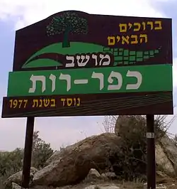
Kfar Ruth
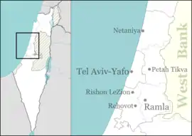
Kfar Ruth (Hebrew: כְּפַר רוּת, lit. Ruth's Village) is an Israeli moshav located near Modi'in in the Latrun salient of the Green Line. It falls under the jurisdiction of Hevel Modi'in Regional Council. In 2019 it had a population of 264.[1]
Kfar Ruth
כְּפַר רוּת | |
|---|---|
 | |
 Kfar Ruth | |
| Coordinates: 31°54′35.64″N 35°2′7.79″E | |
| Country | Israel |
| District | Central |
| Council | Hevel Modi'in |
| Affiliation | Moshavim Movement |
| Founded | 1977 |
| Population (2019)[1] | 264 |
History
The moshav was established in 1977 and was named after the ancient village of Kfar Ruta that appears on the Madaba Map in the area of the new settlement.[2] Prior to the 1948 Arab–Israeli War some of the land had belonged to the Palestinian village of al-Burj, depopulated in the war.[3] According to ARIJ, after the Six-Day War in 1967, Israel confiscated 814 dunams of land from the Palestinian village of Saffa for the construction of Kfar Ruth.[4]
Economy
According to archeologists, grapes were grown in the region by the inhabitants of Modi'in. Tal Maor, a resident of Kfar Ruth, has revived the age-old tradition of winemaking through the establishment of a family winery, Ruth Vineyard.[5]
References
- "Population in the Localities 2019" (XLS). Israel Central Bureau of Statistics. Retrieved 16 August 2020.
- Ben Yosef, Sfi, ed. (2001). מדריך ישראל החדש – השפלה [New Israel Guide – the Shfela] (in Hebrew). 10. Keter.
- Khalidi, Walid (1992). All That Remains: The Palestinian Villages Occupied and Depopulated by Israel in 1948. Washington D.C.: Institute for Palestine Studies. p. 371. ISBN 0-88728-224-5.
- Saffa village profile, ARIJ, p. 17
- "Ruth Vineyard". Archived from the original on 2008-12-30. Retrieved 2009-07-15.
