Khan Kandi, Germi
Khan Kandi (Persian: خان كندي, also Romanized as Khān Kandī)[1] is a village in Ojarud-e Gharbi Rural District, in the Central District of Germi County, Ardabil Province, Iran. At the 2006 census, its population was 18, in 7 families.[2] It is close to the border of Iran and Azerbaijan.[3] [4] [5] [6]
Khan Kandi
خان كندي | |
|---|---|
village | |
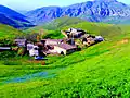
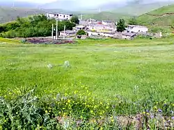 khan kandi village's Panorama | |
 Khan Kandi | |
| Coordinates: 38°55′17″N 48°03′25″E | |
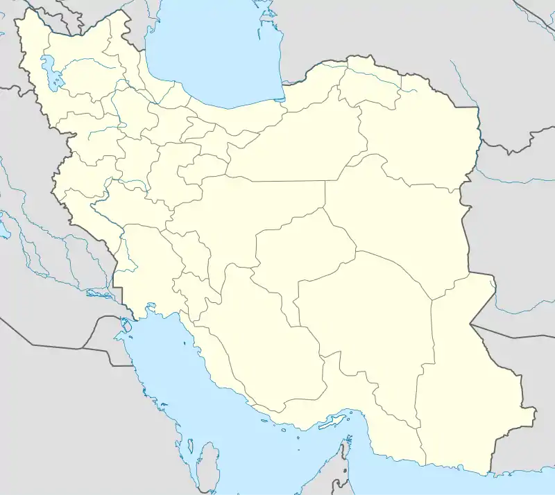
| Country | |
| Province | Ardabil |
| County | Germi |
| Bakhsh | Central |
| Rural District | Ojarud-e Gharbi |
| Elevation | 1,664 m (5,459 ft) |
| Population (2006) | |
| • Total | 18 |
| Time zone | UTC+3:30 (IRST) |
| • Summer (DST) | UTC+4:30 (IRDT) |
| Area code(s) | 655 |

Geography
Khan Kandi lies at latitude 38°55′17" degrees North and 48°3′25" East with average altitude 1,676 meters above sea level. In the central part of Germi city of Ardabil province, in the vicinity villages of Loskeh Daraq, Azizlu, Tulun and on the foothills of Qibla Dashi mountain, is one of the peaks of Salavat-Daghi mountain range.[7] [8] [9] [10] [11] [12]
Climate
KhanKandi village has a cool mountain climate in the summer and is cold and extremely snowy in the winter. The average maximum temperature in July is up to 24 degrees Celsius, while its average temperature decreases to -7C in January and February. The most average rainfall in October is 68 mm and the lowest average rainfall in July is 3 mm. This climatic and topographical position, unique climate and climate of the countryside have caused most of its inhabitants to be pleasant from mid-spring and in the warm months of the year, especially in August and September, from the cool and pleasant climate of the village. To take. Most people live in other parts of the year to carry out their economic activities and earn money in distant cities such as Tehran, Ardebil and Germi. [13] [14] [15]
Biogeography
Due to special natural and geographical conditions, different types of animal life can be seen in the mountains and pastures adjacent to the Khankandi which include: eagle, turtle, poisonous snake, rabbit, fox, jackal, hedgehog, wolf and boar that each species has its own habitat.[16] [17] [18]
Physiography
- The surrounding mountains
One of the most important peaks in the Salavat-Daghi mountain range around Khankandi village is Qoli Dashi (Gholi Tash) with a height of 2200 meters and Qibla Dashi with a height of 2050 meters above sea level, which are located in the south of the village and play an important role in climate change. As the rains begin in the cold seasons, the mountains turn white and a lot of snow settles on them that In the warm seasons the snow melts in these mountains as a result The most famous seasonal river in the city of Germi flows, that is called Tulun Chay. Its water transfer to the city of Germi has been played a major role in the city's water supply.[19] [20] [21] [22] [23] [24] [25]
Vegetation
The nearby heights of Khan Kandi village are covered with lush pastures with a variety of "Self-growing" wild plants, especially the alfalfa and clover mountain. Gavan is a shrub, short, and cushioned plant 10 to 15 cm high, that is found in abundance in highlands and mountainous of khankandi, and the outflow of this plant is called tragacanth. The Gavan species of Khankandi village are thorny type with long and scattered thorns and another type of green Gavan with short compressed thorns that has Sunk into the heart of the earth, so Digging the root of a Gavan is hard and worn. Due to the fact that the Gavan has a good ability to ignite, the residents and shepherds warm themselves by burning the Gavan plant in winter and cold weather, and in the ancient times, some people in the area made a living Costs by digging and selling gavan plants.[26] [27] [28] [29] [30] [31]
History
Khan Kandi was founded simultaneously with the village of Toulon and was an original cornerstone during the rule of Nadir Shah, due to its covered high quality and first-class summer pastures, Khan Kandi has been the summer residence of the Il-Sun nomads since its inception, and the village's original cornerstone seems to have been built by nomads. The founder of that dynasty, Caliph Lu, was a descendant of the Ebabik dynasty, and Khan Kandi in the summer was used by The Ebabiklu clan.The old name of the village was "Khan Yordi" means the place of Stop and Rest of Khawanin and the heads of the local tribes, which later, due to the accommodation of a group of nomads and the formation of a village, was changed to "Khan Kandi" renamed, meaning Khan village. [32] [33] [34] [35]
Population
In the not too distant past Khan Kandi had 15 households with a population of over 150 people but due to migration to cities the village is down to five households and a population of less than 50 people.[36] [37]
Economy and jobs
The main occupation of villagers is in animal husbandry, beekeeping and agriculture.[38] [39] [40] [41]
Tourist Attractions
The Young Journalists Club published a report entitled "Travel to Khan Kandi to reach Cheshmeh Hayat" and introduced Khan Bulaqhi is the fountain of life and wrote: Khan Kandi village is one of the villages in Ardabil province that has an artesian spring in the own south with the name Khan Bulaqhi (the fountain of life). Dana News Agency ranked KhanKandi village in Germi city as one of the top 10 places for travel and tourism in Iran in September 2013.
- The names of some points of Khan Kendi tourist place
- Qalghanlu Goli
- Arpa Chokhori
- khan Yordi
- Toulky Hill
- Chokhour
- Ghoshe Darreh
- Yahar Yourdi
- Evin Osti
- Imash Yeri
- Qibla Dashi
- Khan Bolaghi
Local Foods in Khan Kandi
The followings are some of the most important local foods in Khan Kandi village: Umaj Ashi- Gildik Ashi- Eggplant Dolmeh- Grape leaves Dolmeh- Qovurma- Ayran Ashi- Sutli plov (Rice & Milk)- Raisin plov (Raisin & Rice), Broth, Katteh, Qutab- Khagineh- Khashil- Saj Ichi- Kebab- Pickles.Also the people of Khan Kandi village have a special interest in cooking turkey and goat meat and they believe that the best time to eat turkey is in the fall and after the first rain, which is consistent with the findings of modern and traditional medicine.[48] [49] [50] [51]
Travel address
Travel address to Khan Kandi, Germi city, Ardabil province [52]
- 1- From the side of Ardabil: the old road of Ardabil -Germi from Langan axis - three ways of valve factory of the hero of Bildashi-Tulun village - Khan Kandi
- 2- From the side of Germi : three ways of Bildashi hero valve factory - Tulun village - Khan Kandi
Gallery
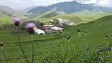
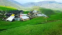
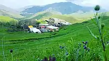
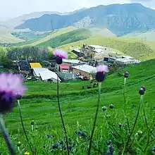
 khankandi Village
.jpg.webp) A Tourist in khankandi Village
A Tourist in khankandi Village- khankandi Village
 khankandi Village
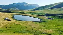
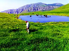 Ghalghanlu Lake in Khan kandi Village
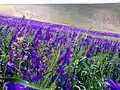 The Khan Kandi, Germi Village Nature Flowers called Blue Farm
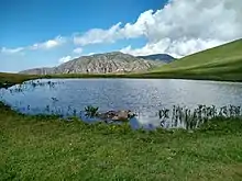 Ghalghanlu Lake in Khan kandi Village
References
- Khan Kandi can be found at GEOnet Names Server, at this link, by opening the Advanced Search box, entering "10082179" in the "Unique Feature Id" form, and clicking on "Search Database".
- "Census of the Islamic Republic of Iran, 1385 (2006)". Islamic Republic of Iran. Archived from the original (Excel) on 2011-11-11.
- Village geography
- KhanKandi :Khān Kandī is one of the tourist villages of Germi
- Introducing Khankandi village of Germi city
- Photo blog of Khankandi village of Germi city
- khan kandi in Iran Village website
- khan kandi Map | Germi Satellite Map
- Khan_kandi in openstreetmap
- KhanKandi :Khān Kandī is one of the tourist villages of Germi
- Introducing Khankandi village of Germi city
- khankandi on pinterest website
- "worldweatheronline". worldweatheronline. Retrieved 2017-11-08.
- "Khan kandi in foreca.com". foreca.com. Retrieved 2019-11-08.
- khan kandi Map | Germi Satellite Map
- Information newspaper report entitled Khankandi; Border village on the slopes of Qibla Dashi mountain
- KhanKandi :Khān Kandī is one of the tourist villages of Germi
- Introducing Khankandi village of Germi city
- The location of Gholi Dash peak in the geographical names base
- khan kandi Map | Germi Satellite Map
- Khan_kandi in openstreetmap
- KhanKandi :Khān Kandī is one of the tourist villages of Germi
- Introducing Khankandi village of Germi city
- Photo blog of Khankandi village of Germi city
- khankandi on pinterest website
- http://ww.24k.ir/content-13844.xhtml/
- KhanKandi :Khān Kandī is one of the tourist villages of Germi
- Introducing Khankandi village of Germi city
- Photo blog of Khankandi village of Germi city
- khankandi on pinterest website
- khan kandi Map | Germi Satellite Map
- Khan_kandi in openstreetmap
- Village history
- KhanKandi :Khān Kandī is one of the tourist villages of Germi
- Introducing Khankandi village of Germi city
- Village population
- Khan_kandi in openstreetmap
- Village economy
- KhanKandi :Khān Kandī is one of the tourist villages of Germi
- Introducing Khankandi village of Germi city
- Khan_kandi in openstreetmap
- KhanKandi :Khān Kandī is one of the tourist villages of Germi
- Introducing Khankandi village of Germi city
- خبرگزاری دانا و 10 پیشنهاد تخصصی سفر در شهریور
- خان کندی در فهرست روستاهای گردشگری ایران
- Photo blog of Khankandi village of Germi city
- khankandi on pinterest website
- The most delicious Azerbaijani food and drink
- KhanKandi :Khān Kandī is one of the tourist villages of Germi
- Introducing Khankandi village of Germi city
- khankandi on pinterest website
- Khan_kandi in openstreetmap
- KhanKandi :Khān Kandī is one of the tourist villages of Germi
- Introducing Khankandi village of Germi city
External links
- khankandi Tourist Village
- http://www.khankandi.mihanblog.com/
- http://www.khankandi.persiangig.com/
- Photo blog of Khankandi village of Germi city