Khorol (river)
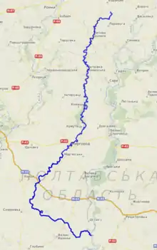
Khorol (Ukrainian: Хорол) is a river in Ukraine, a right tributary of the Psel in the basin of Dnieper. It is 308 kilometres (191 mi) long, and has a drainage basin of 3,340 square kilometres (1,290 sq mi).[1] The Khorol river has its source near the village of Chervona Sloboda in Nedryhailiv Raion, Sumy Oblast.
| Khorol River | |
|---|---|
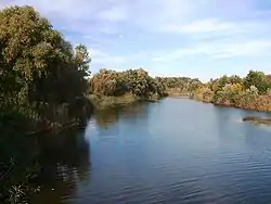 Khorol in Myrhorod | |
 | |
| Location | |
| Country | Ukraine |
| Physical characteristics | |
| Source | |
| • location | Sumy Oblast, Ukraine |
| Mouth | |
• location | Psel |
• coordinates | 49°28′00″N 33°47′18″E |
| Length | 308 km (191 mi) |
| Basin size | 3,340 km2 (1,290 sq mi) |
| Basin features | |
| Progression | Psel→ Dnieper→ Dnieper–Bug estuary→ Black Sea |
General data
The length of 308 km (within Poltava region - 241 km). The area of the catchment area is 3 870 km². The slope of the river is 0.3 m / km. Trapezoidal valley, often asymmetric, with raised right and sloping left slopes; width 10–12 km Floodplain width from 0,2-0,5 km to 1,5–2 km, marshy, shrubby and meadow vegetation. The river channel is wavy with width 10–60 m and more. Power supply is rainy and snowy (spring runoff is about 85% of annual). The average long-term water consumption of Khorol (Myrhorod) is 3.8 m³ / s. The mineralization of water changes during the year: spring flood - 843 mg / dm³; summer-autumn measurements - 966 mg / dm³; winter gauge - 1053 mg / dm³. The river freezes at the end of November - in early December and crashes in March.
Main tributaries
Right: Sakunykha, Rubanka, Vilshana, Tataryna, Oznytsia, Lykhobabivka, Kharpachka, Khomutets, Gremiacha, Kuturzhykha, Avramivka, Lahodynka, Holubykha, Yenkivka, Kryva Ruda, Saha, Tataryna, Shcherbanka.
Left: Berezivka, Staraya Saha, Rudka, Buda, Kholodna.
Populated points
Towns along the river are Lypova Dolyna, Khorol, and the resort town Myrhorod.
Use
It is used for water supply, irrigation, and fishing. Several gateway regulators have been constructed on the river, there are reservoirs.
Khorol in history and culture
A settlement of the Bronze Age was found in the river valley, as well as early Slavic settlements and the burial ground of Chernyakhiv culture. In 1185, a battle between the Rusyns and Polovtsian troops took place on the banks of the river. Landscapes of Khorol have long attracted artists. Here's how the river was written by the famous Ukrainian poet of the twentieth century. Paul Tychyna: "Smoke, smoke from cars, Like maiden summer. Not that now Mirgorod Khorol River is not that ...
Geography
Khorol starts from the sources to the north of the village Chervona Sloboda. Flows Prydniprovska lowland on the territory of Nedryhailiv, Lypova Dolyna raions of the Sumy oblast, Hadiach, Myrhorod, Khorol, Semenivka and Hlobyne raions of the Poltava oblast. Khorol flows mainly to the south, between the cities of Myrhorod and Khorol — to the southwest, then to the south-east. Khorol flows into Psel on the northern outskirts of the village of Popivka, Hlobyne raion, Poltava oblast.
References
- Географічна енциклопедія України: в 3-х томах / Редколегія: О. М. Маринич (відпов. ред.) та ін. — К.: «Українська радянська енциклопедія» імені М. П. Бажана, 1989.
- За ред. А.В. Кудрицького Полтавщина : Енцикл. довід.. — К.: УЕ, 1992. — С. 1024. ISBN 5-88500-033-6
- Енциклопедія українознавства. У 10-х томах. / Головний редактор Володимир Кубійович. — Париж; Нью-Йорк: Молоде життя, 1954—1989.
- «По річках України», К., 1938.