Kibungan
Kibungan, officially the Municipality of Kibungan (Ilocano: Ili ti Kibungan; Tagalog: Bayan ng Kibungan), is a 4th class municipality in the province of Benguet, Philippines. According to the 2015 census, it has a population of 17,292 people. [3]
Kibungan | |
|---|---|
| Municipality of Kibungan | |
.jpeg.webp) Mountains of Kibungan | |
 Seal | |
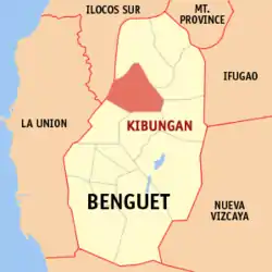 Map of Benguet with Kibungan highlighted | |
OpenStreetMap 
| |
.svg.png.webp) Kibungan Location within the Philippines | |
| Coordinates: 16°57′16″N 120°39′56″E | |
| Country | |
| Region | Cordillera Administrative Region (CAR) |
| Province | Benguet |
| District | Lone district of Benguet |
| Government | |
| • Type | Sangguniang Bayan |
| • Mayor | Cesar M. Molitas |
| • Vice Mayor | Edwin G. Nitron |
| • Representative | Nestor B. Fongwan |
| • Electorate | 9,744 voters (2019) |
| Area | |
| • Total | 254.86 km2 (98.40 sq mi) |
| Elevation | 1,273 m (4,177 ft) |
| Population | |
| • Total | 17,292 |
| • Density | 68/km2 (180/sq mi) |
| • Households | 3,584 |
| Economy | |
| • Income class | 4th municipal income class |
| • Poverty incidence | 18.48% (2015)[4] |
| • Revenue | ₱81,661,378.27 (2016) |
| Time zone | UTC+8 (PST) |
| ZIP code | 2611 |
| PSGC | |
| IDD : area code | +63 (0)74 |
| Climate type | tropical rainforest climate |
| Native languages | Kankanaey Ibaloi Ilocano Tagalog |
Geography
Kibungan is at the northwestern section of Benguet. It is bounded by Bakun on the north, Buguias on the mid-east, Kabayan on the southeast, Atok and Kapangan on the south, and Sugpon on the mid-west.
According to the Philippine Statistics Authority, the municipality has a land area of 254.86 square kilometres (98.40 sq mi) [2] constituting 9.20% of the 2,769.08-square-kilometre- (1,069.15 sq mi) total area of Benguet.
Kibungan has seven barangays namely; Sagpat, Poblacion, Palina, Tacadang, Madaymen, Badeo, and Lubo. Barangay Sagpat and Lubo produces sayote as their main crop, sayote was tagged the "hanging gold". Barangay Madaymen and Palina also produces varieties of vegetables like cabbage, potatoes, carrots, and more. Barangay Tacadang and Badeo is not accessible by vehicle because of the rocky mountains and its hard to construct road.
Kibungan is known in the province of Benguet as the town with unique mountains often mistaken to resemble those of Switzerland. Deep ravines and cliffs separate and isolate many sitios and some barangays. Although some plateaus, hills and small valleys can be seen in the locality, Kibungan is dominantly mountainous.
The municipality is within a cool highland mountainous zone with elevations at more than 2,500 metres (8,200 ft) above sea level. During its coolest months of December to January, Barangay Madaymen experiences chilling temperature of 0 °C (32 °F), causing the famous Frost of Madaymen.
The municipality is located 62 kilometres (39 mi) north of Baguio.
Barangays
Kibungan is politically subdivided into 7 barangays.[5]
| PSGC | Barangay | Population | ±% p.a. | |||
|---|---|---|---|---|---|---|
| 2015 [3] | 2010 [6] | |||||
| 141109001 | Badeo | 5.2% | 894 | 840 | 1.19% | |
| 141109002 | Lubo | 7.1% | 1,230 | 1,235 | −0.08% | |
| 141109003 | Madaymen | 33.2% | 5,738 | 5,875 | −0.45% | |
| 141109004 | Palina | 7.9% | 1,363 | 1,387 | −0.33% | |
| 141109005 | Poblacion | 14.5% | 2,504 | 2,532 | −0.21% | |
| 141109006 | Sagpat | 20.3% | 3,502 | 3,101 | 2.34% | |
| 141109007 | Tacadang | 11.9% | 2,061 | 1,880 | 1.77% | |
| Total | 17,292 | 16,850 | 0.49% | |||
Climate
| Climate data for Kibungan, Benguet | |||||||||||||
|---|---|---|---|---|---|---|---|---|---|---|---|---|---|
| Month | Jan | Feb | Mar | Apr | May | Jun | Jul | Aug | Sep | Oct | Nov | Dec | Year |
| Average high °C (°F) | 22 (72) |
23 (73) |
24 (75) |
25 (77) |
24 (75) |
23 (73) |
22 (72) |
22 (72) |
22 (72) |
23 (73) |
23 (73) |
23 (73) |
23 (73) |
| Average low °C (°F) | 13 (55) |
14 (57) |
15 (59) |
17 (63) |
18 (64) |
18 (64) |
17 (63) |
17 (63) |
17 (63) |
16 (61) |
15 (59) |
14 (57) |
16 (61) |
| Average precipitation mm (inches) | 42 (1.7) |
48 (1.9) |
74 (2.9) |
110 (4.3) |
269 (10.6) |
275 (10.8) |
362 (14.3) |
325 (12.8) |
330 (13.0) |
306 (12.0) |
126 (5.0) |
61 (2.4) |
2,328 (91.7) |
| Average rainy days | 11.2 | 12.0 | 17.1 | 21.2 | 27.1 | 26.8 | 28.1 | 27.0 | 26.0 | 24.5 | 17.7 | 12.4 | 251.1 |
| Source: Meteoblue [7] | |||||||||||||
Demographics
|
| |||||||||||||||||||||||||||||||||||||||||||||
| Source: Philippine Statistics Authority [3] [6] [8][9] | ||||||||||||||||||||||||||||||||||||||||||||||
In the 2015 census, Kibungan had a population of 17,292. [3] The population density was 68 inhabitants per square kilometre (180/sq mi).
Tourism
_-1.jpg.webp)
- Les-eng Rice Terraces: These terraces can be reached after 6-hour hike through lush pine forests in Barangay Tacadang.
- Mayos River: located at the north-eastern part of Barangay Poblacion. It is approximately 2.5 kilometres (1.6 mi) in length and is about 3 kilometres (1.9 mi) away from Poblacion Proper. The river originates from ridges of nearby Barangays Madaymen, Palina and Tacadang; and supplies water to rice paddies and vegetable farms along the vicinity.
- Palina Rice Terraces: In Barangay Palina at the foot of Mount Kilkili, believed to be a former volcano because of its conical shape. It was constructed following a century-old system of rice terraces built with stone walls and neatly arranged one after the other. The rice terraces are at their best in December and June when the rice paddies turn golden yellow, near harvest time. The Palina rice terraces is known as the municipality’s rice granary.
- Lubo Lake: It was an open pit abandoned by the BONENG MINES operated by the WMC due to bankruptcy. The pit was filled with water in the early 2001 due continues rains and typhoons and no way to go out.
- A road network links the area to the town proper and other barangays but public transport vehicles are limited.
- Tacadang Hiking Circuit
.jpeg.webp)
In order to promote the uniqueness of the municipality's ecotourism, the people want the tag "Switzerland of Benguet" removed as of 2007. The tag was created in good faith as the municipality is a mountainous region and has a cool climate that is associated with Switzerland. However, this gives the wrong impression that the municipality has snow-covered peaks for skiing.[10]
Education
Public schools
As of 2014, Kibungan has 24 public elementary schools and 3 public secondary schools.[11][12][13]
|
|
References
- Municipality of Kibungan | (DILG)
- "Province: Benguet". PSGC Interactive. Quezon City, Philippines: Philippine Statistics Authority. Retrieved 12 November 2016.
- Census of Population (2015). "Cordillera Administrative Region (CAR)". Total Population by Province, City, Municipality and Barangay. PSA. Retrieved 20 June 2016.
- "PSA releases the 2015 Municipal and City Level Poverty Estimates". Quezon City, Philippines. Retrieved 12 October 2019.
- "Municipal: Kibungan". PSGC Interactive. Quezon City, Philippines: Philippine Statistics Authority. Retrieved 8 January 2016.
- Census of Population and Housing (2010). "Cordillera Administrative Region (CAR)". Total Population by Province, City, Municipality and Barangay. NSO. Retrieved 29 June 2016.
- "Kibungan: Average Temperatures and Rainfall". Meteoblue. Retrieved 21 March 2020.
- Censuses of Population (1903–2007). "Cordillera Administrative Region (CAR)". Table 1. Population Enumerated in Various Censuses by Province/Highly Urbanized City: 1903 to 2007. NSO.
- "Province of Benguet". Municipality Population Data. Local Water Utilities Administration Research Division. Retrieved 17 December 2016.
- Cariño, Delmar (2007-11-04). "Benguet town drops Switzerland brand". Philippine Daily Inquirer. Archived from the original on 17 February 2008. Retrieved 2007-11-08.
- "Masterlist of Public Elementary Schools for the School year 2012- 2013". Department of Education (Philippines), July 15, 2013. Archived from the original (XLSX) on 4 March 2016. Retrieved 28 December 2014.
- "Masterlist of Secondary Schools (School Year 2013- 2014)". Department of Education (Philippines), July 4, 2013. Archived from the original (XLSX) on 1 July 2014. Retrieved 20 November 2014.
- "Masterlist of Public Schools SY 2013-2014". Department of Education (Philippines), 22 October 2014. Archived from the original (XLSX) on 21 April 2016. Retrieved 28 December 2014.
External links
 Media related to Kibungan, Benguet at Wikimedia Commons
- Kibungan Profile at PhilAtlas.com
- Philippine Standard Geographic Code
La Trinidad (capital) | |
| Municipalities | |
| Highly urbanized city |
|
| Barangays | |