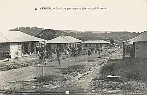
Kindia
Kindia (N’ko: ߞߌ߲ߘߌߦߊ߫) is the fourth largest city in Guinea, lying about 85 miles northeast of the nation's capital, Conakry. Its estimated population in 2008 was 181,126.[1] Kindia serves as the capital and largest city of Kindia Prefecture and Kindia Region. It also forms a sub-prefecture of Guinea.
Kindia | |
|---|---|
Sub-prefecture and town | |
 | |
 Kindia | |
| Coordinates: 10°02′59″N 12°51′15″W | |
| Country | |
| Region | Kindia Region |
| Prefecture | Kindia Prefecture |
| Population (2008) | |
| • Total | 181,126 |
Geography
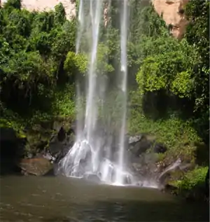
The city is near Mount Gangan and the Mariée Falls.
History
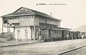
The city was founded in 1904 on the route of Conakry Railway in Kankan.[2]
Economy
Kindia grew around banana plantations after the construction of a now-closed railway to the capital.
Demography
The city of Kindia has an ethnically diverse population, although the Susu make up the majority of the population, followed by the Mandinka. The city is home to virtually all of the country's ethnic groups. After the capital Conakry, Kindia is home to the second largest Sierra Leonean community in Guinea. An estimated 9,000 Sierra Leoneans reside in the city, many of them have obtain Guinean citizenship. Like every cities in Western Guinea, including the capital Conakry, the Susu language is the most widely spoken language in Kindia and is understood by virtually the entire population.
Climate
Kindia has a tropical savanna climate (Köppen climate classification Aw).
| Climate data for Kindia | |||||||||||||
|---|---|---|---|---|---|---|---|---|---|---|---|---|---|
| Month | Jan | Feb | Mar | Apr | May | Jun | Jul | Aug | Sep | Oct | Nov | Dec | Year |
| Average high °C (°F) | 31.8 (89.2) |
33.8 (92.8) |
35.0 (95.0) |
34.2 (93.6) |
31.8 (89.2) |
28.7 (83.7) |
27.1 (80.8) |
26.7 (80.1) |
27.8 (82.0) |
28.9 (84.0) |
30.0 (86.0) |
30.7 (87.3) |
30.5 (86.9) |
| Daily mean °C (°F) | 25.4 (77.7) |
26.8 (80.2) |
27.7 (81.9) |
27.8 (82.0) |
26.6 (79.9) |
24.7 (76.5) |
23.8 (74.8) |
23.4 (74.1) |
24.0 (75.2) |
24.6 (76.3) |
25.3 (77.5) |
25.0 (77.0) |
25.4 (77.7) |
| Average low °C (°F) | 19.0 (66.2) |
19.7 (67.5) |
20.5 (68.9) |
21.4 (70.5) |
21.3 (70.3) |
20.7 (69.3) |
20.4 (68.7) |
20.4 (68.7) |
20.2 (68.4) |
20.3 (68.5) |
20.5 (68.9) |
19.2 (66.6) |
20.3 (68.5) |
| Average precipitation mm (inches) | 1 (0.0) |
2 (0.1) |
12 (0.5) |
48 (1.9) |
175 (6.9) |
243 (9.6) |
371 (14.6) |
464 (18.3) |
351 (13.8) |
225 (8.9) |
39 (1.5) |
7 (0.3) |
1,938 (76.3) |
| Average precipitation days (≥ 1.0 mm) | 0 | 0 | 1 | 4 | 12 | 16 | 23 | 26 | 22 | 17 | 4 | 1 | 126 |
| Average relative humidity (%) | 47 | 45 | 48 | 55 | 69 | 80 | 84 | 86 | 82 | 80 | 73 | 57 | 67 |
| Mean monthly sunshine hours | 247 | 237 | 262 | 230 | 197 | 148 | 106 | 81 | 127 | 163 | 189 | 236 | 2,223 |
| Source: NOAA[3] | |||||||||||||
References
- World Gazetteer Archived 2008-06-17 at the Wayback Machine, Retrieved on June 16, 2008
- Britannica, Kindia, britannica.com, USA, accessed on June 23, 2019
- "Kindia Climate Normals 1961–1990". National Oceanic and Atmospheric Administration. Retrieved July 6, 2015.
Capital: Kindia | ||
| Sub-prefectures | 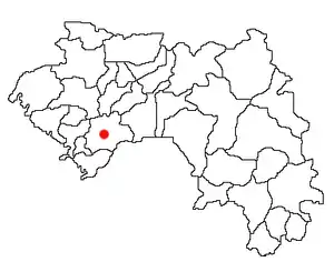 | |