King William's Town
King William’s Town (Xhosa: Qonce) is a town in the Eastern Cape province of South Africa along the banks of the Buffalo River. The town is about 60 kilometres northwest of the Indian Ocean port of East London. King William’s Town is the second most populous city in the Buffalo City Metropolitan Municipality, with a population near 100,000 inhabitants.
King William’s Town | |
|---|---|
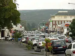 Street in King William’s Town | |
 King William’s Town  King William’s Town  King William’s Town | |
| Coordinates: 32°53′S 27°24′E | |
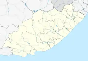
| Country | South Africa |
| Province | Eastern Cape |
| District | Buffalo City |
| Municipality | Buffalo City |
| Established | 1835[1] |
| Area | |
| • Total | 65.52 km2 (25.30 sq mi) |
| Elevation | 398 m (1,306 ft) |
| Population (2011)[2] | |
| • Total | 34,019 |
| • Density | 520/km2 (1,300/sq mi) |
| Racial makeup (2011) | |
| • Black African | 65.3% |
| • Coloured | 25.6% |
| • Indian/Asian | 2.5% |
| • White | 5.6% |
| • Other | 0.9% |
| First languages (2011) | |
| • Xhosa | 54.5% |
| • Afrikaans | 27.3% |
| • English | 13.7% |
| • Other | 4.4% |
| Time zone | UTC+2 (SAST) |
| Postal code (street) | 5601 |
| PO box | 5600 |
| Area code | 043 |
King, as the town is locally called, stands 389 m above the sea at the foot of the Amathole Mountains and in the midst of a densely populated agricultural district. The town has one of the oldest post offices in the country developed by missionaries led by Charles Brownlee.
History
The area was for thousands of years roamed by Bushman bands, and was then used as grazing by the nomadic Khoikhoi, who called the Buffalo River by Qonce. Xhosa people first settled there in the mid- to late 17th century.
The town was founded by Sir Benjamin d’Urban in May 1835 during the Xhosa War of that year, the town stands on the site of the kraal of the minor chief Dyani Tyatyu and is named after William IV. It was abandoned in December 1836, but was reoccupied in 1846 and was the capital of British Kaffraria from its creation in 1847 to its incorporation in 1865 with the Cape Colony. Uniquely in the Cape Colony, its local government was styled a borough, rather than a municipality. Many of the colonists in the neighbouring districts are descendants of members of the British German Legion disbanded after the Crimean War and provided with homes in Cape Colony; hence such names as Berlin, Braunschweig, Frankfurt, Hamburg, Potsdam and Stutterheim given to settlements in this part of the country.
King William’s Town was originally declared the provincial capital of the surrounding Adelaide District in the 1830s. On 5 May 1877, the Cape Government of Prime Minister John Molteno opened the first railway, connecting the town to East London on the coast and to the Xhosa lands inland and further east.[3] With its direct railway communication, the town became an important entrepôt for trade with the Xhosa people throughout Kaffraria.
The area's economy depended on cattle and sheep ranching, and the town itself has a large industrial base producing textiles, soap, candles, sweets, cartons and clothing. In recent years, its proximity to the new provincial capital city of Bhisho has brought much development to the area since the end of apartheid in 1994.
In 2007 the provincial government considered plans to rename the town with a traditional African name, as the current name bears colonial connotations. As of 2020, the change was still just a proposal.[4]
The town is also home to Huberta, one of the farthest-travelling hippopotami in South Africa. It is preserved in the Amathole Museum in the King Williams Town CBD.
Notable people
- Steve Biko, anti-apartheid Black Consciousness Movement leader was born here
- Charles Patrick John Coghlan, first premier of Rhodesia was born here
- Buster Farrer, former international cricket, tennis and hockey player
- Garry Pagel, former South African rugby union player was born here
- John Tengo Jabavu, founder of the first Xhosa-language newspaper in South Africa
- Griffiths Mxenge, anti-apartheid activist
- Victoria Mxenge, anti-apartheid activist
- Steve Tshwete, anti-apatheid activist
- Makhaya Ntini, former South African Test cricketer
- Raven Klaasen, professional tennis player
- Lukhanyo Am, South African Rugby union team player
References
- "Chronological order of town establishment in South Africa based on Floyd (1960:20-26)" (PDF). pp. xlv–lii.
- "Main Place King William's Town". Census 2011.
- Burman, Jose (1984), Early Railways at the Cape. Cape Town: Human & Rousseau, p.83. ISBN 0-7981-1760-5
- Staff Writer (3 September 2020). "Name changes planned for East London and other Eastern Cape towns". businesstech.co.za. Retrieved 13 January 2021.
 This article incorporates text from a publication now in the public domain: Chisholm, Hugh, ed. (1911). "King William's Town". Encyclopædia Britannica. 15 (11th ed.). Cambridge University Press. p. 822.
External links
| Wikimedia Commons has media related to King William's Town. |
Communities of Buffalo City Metropolitan Municipality, Eastern Cape | ||
|---|---|---|
Seat: East London | ||
| Cities and towns |
| .svg.png.webp) Buffalo City within South Africa |
| Authority control |
|---|