Provinces of South Africa
South Africa is divided into nine provinces.[1] On the eve of the 1994 general election, South Africa's former homelands, also known as Bantustans, were reintegrated and the four existing provinces were divided into nine. The twelfth, thirteenth and sixteenth amendments to the Constitution of South Africa changed the borders of seven of the provinces.
| South African Provinces | |
|---|---|
| Category | Unitary state |
| Location | South Africa |
| Number | 9 Provinces |
| Populations | 1,145,861 (Northern Cape) – 12,272,263 (Gauteng) |
| Areas | 47,080 km2 (18,178 sq mi) (Gauteng) – 372,890 km2 (143,973 sq mi) (Northern Cape) |
| Government | Provincial government, National government |
| Subdivisions | Districts |
 |
|---|
| This article is part of a series on the politics and government of South Africa |
|
|
History
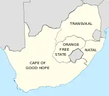
The Union of South Africa was established in 1910 by combining four British colonies: the Cape Colony, the Natal Colony, the Transvaal Colony and the Orange River Colony (the latter two were, before the Second Boer War, independent republics known as the South African Republic and the Orange Free State). These colonies became the four original provinces of the Union: Cape Province, Transvaal Province, Natal Province and Orange Free State Province.
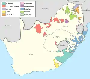
Segregation of the black population started as early as 1913, with ownership of land by the black majority being restricted to certain areas totalling about 13% of the country. From the late 1950s, these areas were gradually consolidated into "homelands", also called "bantustans". Four of these homelands were established as quasi-independent nation states of the black population during the apartheid era. In 1976, the homeland of Transkei was the first to accept independence from South Africa, and although this independence was never acknowledged by any other country, three other homelands – Bophuthatswana (1977), Venda (1979) and Ciskei (1981) – followed suit.
On 27 April 1994, the date of the first non-racial elections and of the adoption of the Interim Constitution, all of these provinces and homelands were dissolved, and nine new provinces were established. The boundaries of these provinces were established in 1993 by a Commission on the Demarcation/Delimitation of Regions created by CODESA, and were broadly based on planning regions demarcated by the Development Bank of Southern Africa in the 1980s,[2][3] and amalgamated from existing magisterial districts, with some concessions to political parties that wished to consolidate their power bases, by transferring districts between the proposed provinces.[4][5] The definitions of the new provinces in terms of magisterial districts were found in Schedule 1 of the Interim Constitution.
Government
South Africa's provinces are governed, in different ways, on a national, provincial and local level.[6]
Nationally, there is the National Council of Provinces, one of the houses of Parliament. Then there is the provincial government and, below that, the administration of district and metropolitan municipalities.
National Council of Provinces
South Africa has two houses of parliament: the National Assembly, and the National Council of Provinces.[6] The second exists to ensure that the interests of each province are protected in the laws passed by the National Assembly.
Each one of South Africa's nine provinces sends 10 representatives to the National Council of Provinces. Six of these are permanent members of the council, and four are special delegates.
Provincial government
Each province is governed by a unicameral legislature. The size of the legislature is proportional to population, ranging from 30 members in the Northern Cape to 80 in KwaZulu-Natal. The legislatures are elected every five years by a system of party-list proportional representation; by convention, they are all elected on the same day, at the same time as the National Assembly election.[7]
The provincial legislature elects, from amongst its members, a Premier, who is the head of the executive. The Premier chooses an Executive Council consisting of between five and ten members of the legislature, which is the cabinet of the provincial government.[7] The Members of the Executive Council (MECs) are the provincial equivalent of ministers.
The powers of the provincial government are limited to specific topics listed in the national constitution. On some of these topics – for example, agriculture, education, health and public housing – the province's powers are shared with the national government, which can establish uniform standards and frameworks for the provincial governments to follow; on other topics the provincial government has exclusive power.[8]
The provinces do not have their own court systems, as the administration of justice is the responsibility of the national government.
The provinces of South Africa
| Province | Name in the most spoken native language[9] | Capital | Largest city | Area[10]:9 | Population (2011)[10]:18 |
Population density (2011) |
Human Devel. Index (2003) [11] |
Location |
|---|---|---|---|---|---|---|---|---|
| Eastern Cape | iMpuma-Koloni (Xhosa) | Bhisho (Bisho) | Port Elizabeth | 168,966 km2 (65,238 sq mi) | 6,562,053 | 38.8/km2 (100/sq mi) | 0.62 | |
| Free State | Freistata (Sotho) | Bloemfontein | Bloemfontein | 129,825 km2 (50,126 sq mi) | 2,745,590 | 21.1/km2 (55/sq mi) | 0.67 | |
| Gauteng | eGoli (Zulu) | Johannesburg | Johannesburg | 18,178 km2 (7,019 sq mi) | 12,272,263 | 675.1/km2 (1,749/sq mi) | 0.74 | |
| KwaZulu-Natal | iKwaZulu-Natali (Zulu) | Pietermaritzburg [n 1] | Durban | 94,361 km2 (36,433 sq mi) | 10,267,300 | 108.8/km2 (282/sq mi) | 0.63 | |
| Limpopo | Limpopo (Northern Sotho) | Polokwane (Pietersburg) | Polokwane | 125,754 km2 (48,554 sq mi) | 5,404,868 | 43.0/km2 (111/sq mi) | 0.59 | |
| Mpumalanga | iMpumalanga (Swazi) | Mbombela (Nelspruit) | Mbombela | 76,495 km2 (29,535 sq mi) | 4,039,939 | 52.8/km2 (137/sq mi) | 0.65 | |
| North West | Bokone Bophirima (Tswana) | Mahikeng (Mafikeng) | Klerksdorp | 104,882 km2 (40,495 sq mi) | 3,509,953 | 33.5/km2 (87/sq mi) | 0.61 | |
| Northern Cape | Noord-Kaap (Afrikaans) | Kimberley | Kimberley | 372,889 km2 (143,973 sq mi) | 1,145,861 | 3.1/km2 (8.0/sq mi) | 0.69 | |
| Western Cape [n 2] | Wes-Kaap (Afrikaans) | Cape Town | Cape Town | 129,462 km2 (49,986 sq mi) | 5,822,734 | 45.0/km2 (117/sq mi) | 0.77 | |
| Republic of South Africa | iRiphabhuliki yaseNingizimu Afrika (Zulu) | Pretoria, Cape Town, Bloemfontein | Johannesburg | 1,220,813 km2 (471,359 sq mi) | 51,770,560 | 42.4/km2 (110/sq mi) | 0.67 | |
Footnotes:
- Pietermaritzburg and Ulundi were joint capitals of KwaZulu-Natal from 1994 to 2004.
- These statistics do not include the Prince Edward Islands (335 km2, 129 sq mi, with no permanent residents), which are South African territories in the sub-Antarctic Indian Ocean but part of the Western Cape for legal and electoral purposes.
Provincial acronyms
| Province | HASC | ISO | FIPS | CSS | Conventional |
|---|---|---|---|---|---|
| Eastern Cape | ZA.EC | EC | SF05 | 02 | EC |
| Free State | ZA.FS | FS | SF03 | 04 | FS |
| Gauteng | ZA.GT | GP | SF06 | 07 | GP |
| KwaZulu-Natal | ZA.NL | KZN | SF02 | 05 | KZN |
| Limpopo | ZA.NP | LP | SF09 | 09 | LP |
| Mpumalanga | ZA.MP | MP | SF07 | 08 | MP |
| Northern Cape | ZA.NC | NC | SF08 | 03 | NC |
| North-West | ZA.NW | NW | SF10 | 06 | NW |
| Western Cape | ZA.WC | WC | SF11 | 01 | WC |
| Notes HASC: Hierarchical administrative subdivision codes | |||||
Former administrative divisions
| Province | Capital | Peak population | Location |
|---|---|---|---|
| Cape of Good Hope (1910–1994) | Cape Town | 6,125,335 | |
| Natal (1910–1994) | Pietermaritzburg | 2,430,753 | |
| Orange Free State (1910–1994) | Bloemfontein | 2,193,062 | |
| Transvaal (1910–1994) | Pretoria | 9,491,265 | |
| Homelands | Capital | Peak population | Location |
| Bophuthatswana (1977–1994) † | Mmabatho | 1,478,950 | |
| Ciskei (1972–1994) † | Bisho | 677,920 | |
| Gazankulu (1971–1994) | Giyani | 954,771 | |
| KaNgwane (1981–1994) | Louieville Schoemansdal (de facto) | 779,240 | |
| KwaNdebele (1981–1994) | KwaMhlanga | 404,246 | |
| KwaZulu (1981–1994) | Nongoma (until 1980) Ulundi (1980–1994) | 5,524,774 | |
| Lebowa (1972–1994) | Lebowakgomo | 2,740,587 | |
| QwaQwa (1974–1994) | Phuthaditjhaba | 342,886 | |
| Transkei (1976–1994) † | Umtata | 2,323,650 | |
| Venda (1979–1994) † | Thohoyandou | 558,797 | |
| Mandates | Capital | Peak population | |
| South-West Africa | Windhoek | 1,415,000 |
Footnotes:
- † States for which the homeland was quasi-independent.
See also
- Elections in South Africa
- List of municipalities in South Africa
- Members of the Executive Council (MEC)
- Prince Edward Islands
- Proposals for South Africa to annex Lesotho
- Provincial governments of South Africa
- Provincial legislature (South Africa)
- Telephone numbers in South Africa
- Vehicle registration plates of South Africa
- Walvis Bay
- ISO 3166-2:ZA
References
- "The nine provinces of South Africa - South Africa Gateway". South Africa Gateway. 6 April 2018. Retrieved 14 April 2018.
- https://core.ac.uk/download/pdf/37351010.pdf
- Phillips, Laura (27 July 2017). "History of South Africa's Bantustans". Oxford Research Encyclopedia of African History. doi:10.1093/acrefore/9780190277734.001.0001 (inactive 11 January 2021).CS1 maint: DOI inactive as of January 2021 (link)
- https://www.dur.ac.uk/ibru/publications/download/?id=55
- Muthien, Yvonne G.; Khosa, Meshack M. (1995). "'The kingdom, the Volkstaat and the New South Africa': Drawing South Africa's new regional boundaries". Journal of Southern African Studies. 21 (2): 303–322. doi:10.1080/03057079508708448.
- "The nine provinces of South Africa - South Africa Gateway". South Africa Gateway. 6 April 2018. Retrieved 14 April 2018.
- "Provincial Government of South Africa". Retrieved 20 November 2017.
- 'Constitution of the Republic of South Africa, 1996, "Chapter 6: Provinces". Sections 104 and 146.
- http://www.statssa.gov.za/census/census_2011/census_products/Census_2011_Census_in_brief.pdf, p. 25.
- Census 2011: Census in brief (PDF). Pretoria: Statistics South Africa. 2012. p. 30. ISBN 9780621413885. Archived (PDF) from the original on 13 May 2015.
- Adelzadeh, Asghar; et al. (2003). South Africa Human Development Report 2003 (PDF). Cape Town: Oxford University Press. p. 282. ISBN 978-0-19-578418-3.
- "South African Provinces".
| Ranked |  | |
|---|---|---|
| Political |
| |
| Other | ||
| |||||||
| Provinces | |||||||
| Municipalities |
| ||||||
| Settlements |
| ||||||