Kingman, Kansas
Kingman is a city in and the county seat of Kingman County, Kansas, United States.[7] As of the 2010 census, the city population was 3,177.[8]
Kingman, Kansas | |
|---|---|
City and County seat | |
 Downtown Kingman (2009) | |
 Location within Kingman County and Kansas | |
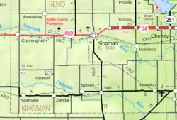 KDOT map of Kingman County (legend) | |
| Coordinates: 37°38′49″N 98°6′50″W | |
| Country | United States |
| State | Kansas |
| County | Kingman |
| Township | Kingman |
| Platted | 1874 |
| Incorporated | 1883 |
| Government | |
| • Type | Council-Manager |
| • Mayor | Mark Arensdorf [1] |
| • City Manager | Greg Graffman [1] |
| Area | |
| • Total | 3.47 sq mi (9.00 km2) |
| • Land | 3.46 sq mi (8.97 km2) |
| • Water | 0.01 sq mi (0.03 km2) |
| Elevation | 1,522 ft (464 m) |
| Population | |
| • Total | 3,177 |
| • Estimate (2019)[4] | 2,842 |
| • Density | 820.91/sq mi (317.00/km2) |
| Time zone | UTC-6 (CST) |
| • Summer (DST) | UTC-5 (CDT) |
| ZIP code | 67068 |
| Area code | 620 |
| FIPS code | 20-36950 [5] |
| GNIS ID | 0473965 [6] |
| Website | CityOfKingman.com |
History
Kingman was laid out in 1874.[9] Like Kingman County, it was named for Samuel A. Kingman, chief justice of the supreme court.[10]
Geography
Kingman is located at 37°38′49″N 98°6′50″W (37.647024, -98.113805).[11] According to the United States Census Bureau, the city has a total area of 3.53 square miles (9.14 km2), of which 3.52 square miles (9.12 km2) is land and 0.01 square miles (0.03 km2) is water.[12]
Climate
The climate in this area is characterized by hot, humid summers and generally mild to cool winters. According to the Köppen Climate Classification system, Kingman has a humid subtropical climate, abbreviated "Cfa" on climate maps.[13]
Demographics
| Historical population | |||
|---|---|---|---|
| Census | Pop. | %± | |
| 1890 | 2,390 | — | |
| 1900 | 1,785 | −25.3% | |
| 1910 | 2,570 | 44.0% | |
| 1920 | 2,407 | −6.3% | |
| 1930 | 2,752 | 14.3% | |
| 1940 | 3,213 | 16.8% | |
| 1950 | 3,200 | −0.4% | |
| 1960 | 3,582 | 11.9% | |
| 1970 | 3,622 | 1.1% | |
| 1980 | 3,563 | −1.6% | |
| 1990 | 3,196 | −10.3% | |
| 2000 | 3,387 | 6.0% | |
| 2010 | 3,177 | −6.2% | |
| 2019 (est.) | 2,842 | [4] | −10.5% |
| U.S. Decennial Census | |||
2010 census
As of the census[3] of 2010, there were 3,177 people, 1,346 households, and 810 families living in the city. The population density was 902.6 inhabitants per square mile (348.5/km2). There were 1,546 housing units at an average density of 439.2 per square mile (169.6/km2). The racial makeup of the city was 96.7% White, 0.1% African American, 0.7% Native American, 0.4% Asian, 0.9% from other races, and 1.2% from two or more races. Hispanic or Latino of any race were 2.7% of the population.
There were 1,346 households, of which 29.3% had children under the age of 18 living with them, 46.7% were married couples living together, 9.7% had a female householder with no husband present, 3.9% had a male householder with no wife present, and 39.8% were non-families. 35.0% of all households were made up of individuals, and 18% had someone living alone who was 65 years of age or older. The average household size was 2.29 and the average family size was 2.95.
The median age in the city was 40.7 years. 24.9% of residents were under the age of 18; 8% were between the ages of 18 and 24; 21.6% were from 25 to 44; 23.3% were from 45 to 64; and 22.2% were 65 years of age or older. The gender makeup of the city was 47.7% male and 52.3% female.
2000 census
As of the census[5] of 2000, there were 3,387 people, 1,407 households, and 911 families living in the city. The population density was 975.8 people per square mile (376.9/km2). There were 1,563 housing units at an average density of 450.3 per square mile (173.9/km2). The racial makeup of the city was 97.67% White, 0.21% African American, 0.35% Native American, 0.50% Asian, 0.30% from other races, and 0.97% from two or more races. Hispanic or Latino of any race were 1.92% of the population.
There were 1,407 households, out of which 28.9% had children under the age of 18 living with them, 52.7% were married couples living together, 9.5% had a female householder with no husband present, and 35.2% were non-families. 33.0% of all households were made up of individuals, and 18.8% had someone living alone who was 65 years of age or older. The average household size was 2.34 and the average family size was 2.95.
In the city, the population was spread out, with 26.4% under the age of 18, 7.1% from 18 to 24, 23.6% from 25 to 44, 20.2% from 45 to 64, and 22.7% who were 65 years of age or older. The median age was 40 years. For every 100 females, there were 84.3 males. For every 100 females age 18 and over, there were 82.7 males.
The median income for a household in the city was $36,018, and the median income for a family was $42,813. Males had a median income of $32,000 versus $23,988 for females. The per capita income for the city was $19,286. About 10.3% of families and 12.2% of the population were below the poverty line, including 24.4% of those under age 18 and 7.0% of those age 65 or over.
Education
The community is served by Kingman-Norwich USD 331 public school district, which operates 2 schools in Kingman.
- Kingman High School
- Kingman Elementary-Middle School
Private Schools
Transportation
Bus service is provided daily eastward towards Wichita, Kansas and westward towards Pueblo, Colorado by BeeLine Express (subcontractor of Greyhound Lines).[14][15]
Notable people
- George Aiton, Major League Baseball player.
- Clyde Cessna, founder of the Cessna Aircraft Corporation.
- Martin Dewey, American orthodontist.
- Eugene John Gerber, Roman Catholic bishop.
- Don Lock, Major League Baseball player.
Gallery
- Historic Images of Kingman, Special Photo Collections at Wichita State University Library
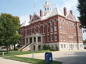 Kingman County Courthouse (2009)
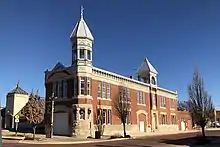 Old City Hall Building (2017)
 Kingman Carnegie Library (2012)
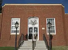 Kingman U.S. Post Office (2014)
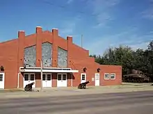 Kingman National Guard Armory (2014)
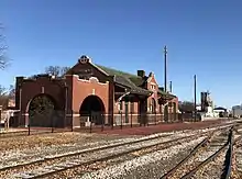 Former Kingman Santa Fe Depot (2017)
References
- Kingman - Directory of Public Officials Archived 2011-12-13 at the Wayback Machine
- "2019 U.S. Gazetteer Files". United States Census Bureau. Retrieved July 24, 2020.
- "U.S. Census website". United States Census Bureau. Retrieved 2012-07-06.
- "Population and Housing Unit Estimates". United States Census Bureau. May 24, 2020. Retrieved May 27, 2020.
- "U.S. Census website". United States Census Bureau. Retrieved 2008-01-31.
- "US Board on Geographic Names". United States Geological Survey. 2007-10-25. Retrieved 2008-01-31.
- "Find a County". National Association of Counties. Archived from the original on 2011-05-31. Retrieved 2011-06-07.
- "2010 City Population and Housing Occupancy Status". U.S. Census Bureau. Retrieved March 6, 2011.
- Blackmar, Frank Wilson (1912). Kansas: A Cyclopedia of State History. Standard Publishing Company. pp. 72.
- Kansas State Historical Society (1916). Biennial Report of the Board of Directors of the Kansas State Historical Society. Kansas State Printing Plant. pp. 215.
- "US Gazetteer files: 2010, 2000, and 1990". United States Census Bureau. 2011-02-12. Retrieved 2011-04-23.
- "US Gazetteer files 2010". United States Census Bureau. Archived from the original on 2012-07-02. Retrieved 2012-07-06.
- Climate Summary for Kingman, Kansas
- BeeLine Express
- "Greyhound Lines". Archived from the original on 2019-09-06. Retrieved 2016-01-03.
Further reading
External links
| Wikimedia Commons has media related to Kingman, Kansas. |
Municipalities and communities of Kingman County, Kansas, United States | ||
|---|---|---|
| Cities | 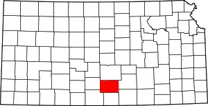 Map of Kansas highlighting Kingman County | |
| Unincorporated communities | ||
| Townships | ||
| ||
| Authority control |
|---|
