Kisilyakh Range
The Kisilyakh Range (Russian: Кисиляхский хребет; Yakut: Киһилээх) is a mountain range in the Sakha Republic, Far Eastern Federal District, Russia.[1] The nearest city is Batagay, and the nearest airport Batagay Airport.[2]
| Kisilyakh Range | |
|---|---|
| Кисиляхский хребет / Киһилээх | |
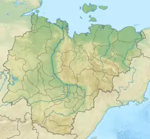 Location in Sakha, Russia | |
| Highest point | |
| Elevation | 1,548 m (5,079 ft) |
| Dimensions | |
| Length | 80 km (50 mi) |
| Width | 20 km (12 mi) |
| Geography | |
| Country | Russia |
| Federal subject | Sakha Republic |
| Range coordinates | 68°10′N 136°0′E |
| Parent range | Chersky Range, East Siberian System |
| Geology | |
| Age of rock | Triassic, Jurassic and Cretaceous |
| Type of rock | Shale, mudstone, siltstone, Sandstone, granite and granitoid intrusions |
| Climbing | |
| Easiest route | From Batagay |
The mountains are topped by kigilyakh rock formations. Some of the finest kigilyakhs in Yakutia are located in this range,[3] the tallest among them reaching a height of 30 meters (98 ft).[4] Kisilyakh means "Mountain having a man" or "Mountain married" in the Yakut language.[5]
Geography
The Kisilyakh Range rises at the northeastern end of the Chersky Range, in the Sakha region. They mountains are of middle height and the range is one of the smallest of the system. It stretches in a roughly WNW/ESE direction for about 80 kilometers (50 mi). The highest peak is 1,548 metres (5,079 ft) high.[2] The range consists of two ridges divided into an eastern and western part by a cleft.[6]
The Khadaranya Range, another subrange of the Chersky Mountains, rises further to the east and the Adycha River flows across the range in its western part.[7]
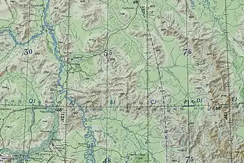 Map section centered on the Kisilyakh Range |