Kluisbergen
Kluisbergen (Dutch pronunciation: [ˈklœyzbɛrɣə(n)]) is a municipality located in the Belgian province of East Flanders, along the Scheldt river. The municipality comprises the towns of Berchem (Kluisbergen), Kwaremont, Ruien and Zulzeke which fused in 1971. On January 1, 2006, Kluisbergen had a total population of 6,161. The total area is 30.38 km² which gives a population density of 203 inhabitants per km². The town of Ruien is the largest and has some outdoor facilities. Kluisbergen is also home to the "Kluisbos", a forest which has 2 ancient standing stones, dating back to Roman times.
Kluisbergen | |
|---|---|
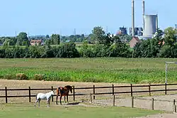 Landscape with the old coal power plant in Ruien | |
 Flag  Coat of arms | |
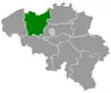
 Kluisbergen Location in Belgium
Location of Kluisbergen in East Flanders  | |
| Coordinates: 50°47′N 03°31′E | |
| Country | Belgium |
| Community | Flemish Community |
| Region | Flemish Region |
| Province | East Flanders |
| Arrondissement | Oudenaarde |
| Government | |
| • Mayor | Philippe Willequet |
| • Governing party/ies | Gemeentebelangen |
| Area | |
| • Total | 30.38 km2 (11.73 sq mi) |
| Population (2018-01-01)[1] | |
| • Total | 6,453 |
| • Density | 210/km2 (550/sq mi) |
| Postal codes | 9690 |
| Area codes | 055 |
| Website | www.kluisbergen.be |
Geography
Kluisbergen consists of four towns:
| I | Berchem |
| II | Ruien |
| III | Kwaremont |
| IV | Zulzeke |
Neighbouring towns/municipalities:
| a | Ronse |
| b | Nukerke (Maarkedal) |
| c | Melden (Oudenaarde) |
| d | Elsegem (Wortegem-Petegem) |
| e | Kerkhove (Avelgem) |
| f | Waarmaarde (Avelgem) |
| g | Avelgem (Avelgem) |
| h | Orroir (Mont-de-l'Enclus) |
| i | Amengies (Mont-de-l'Enclus) |
| j | Russeignies (Mont-de-l'Enclus) |
Map

Landscape
The Scheldt makes up the northwestern border of Kluisbergen where the landscape is rather flat. Traveling south or southeast is met with an increasing moderately hilly landscape all the way to the southern border
There are three main hills in Kluisbergen. The Kluisberg is mainly located on the border of Ruien and Orroir, stretching all the way to Kwaremont. The Paterberg is located in the middle of Kwaremont. The Hotondberg is located on the border of Zulzeke and Ronse and is the highest point of East Flanders. The three hills are the westernmost hills of the Flemish Ardennes.
Tourism
Flemish Ardennes are known for their steep hills with several of them having forests on their hillsides. Kluisbergen is no exception and is best known for these hills. Their important role in the Tour of Flanders make them popular among cyclists. The municipality incorporates its many field trails in hiking routes with hiking tours are also being organized.
Kwaremont has the title of "Artist Village" because of its numerous painters and art galleries.
References
- "Wettelijke Bevolking per gemeente op 1 januari 2018". Statbel. Retrieved 9 March 2019.
External links
 Media related to Kluisbergen at Wikimedia Commons
- Official website (in Dutch)
Places adjacent to Kluisbergen | ||||||||||
|---|---|---|---|---|---|---|---|---|---|---|
| ||||||||||