Kobeliaky Raion
Kobeliaky Raion (Ukrainian: Кобеляцький район; translit.: Kobeliats'kyi Raion) was a raion (district) in Poltava Oblast in central Ukraine. The raion's administrative center was the city of Kobeliaky. The raion was abolished on 18 July 2020 as part of the administrative reform of Ukraine, which reduced the number of raions of Poltava Oblast to four.[1][2] The last estimate of the raion population was 40,172 (2020 est.)[3]
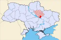
Kobeliaky Raion
Кобеляцький район | |
|---|---|
 Flag  Coat of arms | |
 | |
| Coordinates: 49°3′4.3842″N 34°9′38.0442″E | |
| Country | |
| Region | Poltava Oblast |
| Established | 7 March 1923 |
| Disestablished | 18 July 2020 |
| Admin. center | Kobeliaky |
| Subdivisions | List
|
| Area | |
| • Total | 1,823 km2 (704 sq mi) |
| Population (2020) | |
| • Total | 40,172 |
| • Density | 22/km2 (57/sq mi) |
| Time zone | UTC+02:00 (EET) |
| • Summer (DST) | UTC+03:00 (EEST) |
| Area code | +380 |
| Website | Official homepage |
Important rivers within the Kobeliatskyi Raion included the Dnieper and the Vorskla. The raion was established on March 7, 1923.
Settlements
|
|
|
References
- "Про утворення та ліквідацію районів. Постанова Верховної Ради України № 807-ІХ". Голос України (in Ukrainian). 2020-07-18. Retrieved 2020-10-03.
- "Нові райони: карти + склад" (in Ukrainian). Міністерство розвитку громад та територій України.
- "Чисельність наявного населення України (Actual population of Ukraine)" (PDF) (in Ukrainian). State Statistics Service of Ukraine. Retrieved 30 September 2020.
| Raions | |||||
|---|---|---|---|---|---|
| Hromadas | |||||
| Cities |
| ||||
| |||||
This article is issued from Wikipedia. The text is licensed under Creative Commons - Attribution - Sharealike. Additional terms may apply for the media files.
