Koether Inlet
Koether Inlet is an ice-filled inlet about 18 nautical miles (33 km) long, indenting the north coast of Thurston Island, Antarctica, between Edwards Peninsula and Evans Peninsula.[1] It was first delineated from air photos taken by U.S. Navy Squadron VX-6 in January 1960. The inlet was named by the Advisory Committee on Antarctic Names (US-ACAN) for Ensign Bernard Koether, a navigator on USS Glacier (AGB-4) in February 1960 who assisted in the charting of the Thurston Island coastline and in the accurate location of soundings.[1]

Koether Inlet
Location of Koether Inlet in Antarctica
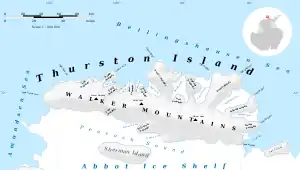
Map of Thurston Island.
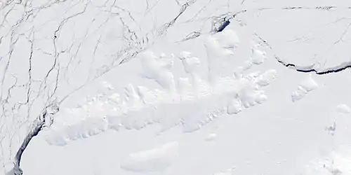
Satellite image of Thurston Island.
Maps
- Thurston Island – Jones Mountains. 1:500000 Antarctica Sketch Map. US Geological Survey, 1967.
- Antarctic Digital Database (ADD). Scale 1:250000 topographic map of Antarctica. Scientific Committee on Antarctic Research (SCAR), 1993–2016.
References
- "Koether Inlet". Geographic Names Information System. United States Geological Survey. Retrieved 2013-05-13.
![]() This article incorporates public domain material from websites or documents of the United States Geological Survey.
This article incorporates public domain material from websites or documents of the United States Geological Survey.
This article is issued from Wikipedia. The text is licensed under Creative Commons - Attribution - Sharealike. Additional terms may apply for the media files.
