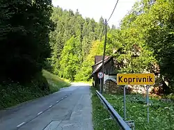
Koprivnik, Žiri
Koprivnik (pronounced [kɔˈpɾíːwnik]; German: Kopriunik[2]) is a small dispersed settlement northwest of Žiri in the Upper Carniola region of Slovenia.[3] It consists of isolated farms in the hills above the right bank of Sovodenjščica Creek (a.k.a. Hobovščica Creek), extending from the Javorščica Gorge to the hills above Fužine. The territory of the settlement ranges between 515 and 810 m in elevation.[4]
Koprivnik | |
|---|---|
 | |
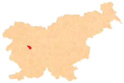
 Koprivnik Location in Slovenia | |
| Coordinates: 46°4′38.48″N 14°3′37.42″E | |
| Country | |
| Traditional region | Upper Carniola |
| Statistical region | Upper Carniola |
| Municipality | Žiri |
| Area | |
| • Total | 5.8 km2 (2.2 sq mi) |
| Elevation | 662.5 m (2,173.6 ft) |
| Population (2012) | |
| • Total | 103 |
| [1] | |
References
- Statistical Office of the Republic of Slovenia Archived November 18, 2008, at the Wayback Machine
- Leksikon občin kraljestev in dežel zastopanih v državnem zboru, vol. 6: Kranjsko. 1906. Vienna: C. Kr. Dvorna in Državna Tiskarna, p. 59.
- Žiri municipal site
- Savnik, Roman (1968). Krajevni leksikon Slovenije, vol. 1. Ljubljana: Državna založba Slovenije. p. 364.
External links
 Media related to Koprivnik at Wikimedia Commons
- Koprivnik on Geopedia
| Settlements | Administrative centre: Žiri
|  | ||||
|---|---|---|---|---|---|---|
| Landmarks |
| |||||
| Notable people | ||||||
This article is issued from Wikipedia. The text is licensed under Creative Commons - Attribution - Sharealike. Additional terms may apply for the media files.