Kossi Province
The Province de la Kossi lies in the western part of Burkina Faso and stretches to the border with Mali. It is in the Boucle du Mouhoun Region. The capital of Kossi is the town of Nouna, which has a mayor and high commissioner. The next largest town in Kossi is Djibasso, the last major town on the road from Nouna that heads west into Mali.
Kossi | |
|---|---|
Province | |
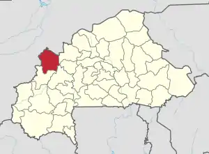 Location in Burkina Faso | |
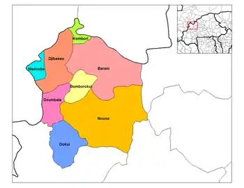 Provincial map of its departments | |
| Country | |
| Region | Boucle du Mouhoun |
| Capital | Nouna |
| Area | |
| • Province | 2,829 sq mi (7,328 km2) |
| Population (2019 census)[1] | |
| • Province | 355,655 |
| • Density | 130/sq mi (49/km2) |
| • Urban | 32,427 |
| Time zone | UTC+0 (GMT 0) |
In the early 2010s, a major road through the Kossi was paved with support from the Millennium Challenge Corporation. The road links the major towns of Dedougou and Nouna, then continues westward to Djibasso and the border with Mali.
Education
In 2011 the province had 214 primary schools and 20 secondary schools.[2]
Healthcare
In 2011 the province had 22 health and social promotion centers (Centres de santé et de promotion sociale), 5 doctors and 93 nurses.[3]
Demographics
The population of Kossi in 2006 was 272,223. It is a rural province with 253,793 of its residents living in the countryside; only 18,440 live in urban areas. There are 135,342 men living in Kossi Province and 136,891 women.[4]
Departments
Kossi is divided into 10 departments:
| Departments | Capitals | Population (Census 2006)[4] |
|---|---|---|
| Barani Department | Barani | 44,237 |
| Bomborokui Department | Bomborokui | 15,257 |
| Bourasso Department | Bourasso | 12,548 |
| Djibasso Department | Djibasso | 49,730 |
| Dokuy Department | Dokuy | 28,642 |
| Doumbala Department | Doumbala | 26,643 |
| Kombori Department | Kombori | 8,300 |
| Madouba Department | Madouba | 6,590 |
| Nouna Department | Nouna | 70,010 |
| Sono Department | Sono | 7,276 |
References
- Citypopulation.de Population of provinces in Boucle du Mouhoun Region
- "La région du Boucle du Mouhoun en chiffres" (PDF). Institut National de la Statistique et de la Démographie (INSD). 2011. p. 6. Archived from the original (PDF) on 2012-11-13.
- "La région du Boucle du Mouhoun en chiffres" (PDF). Institut National de la Statistique et de la Démographie (INSD). 2011. p. 6. Archived from the original (PDF) on 2012-11-13.
- National 2006 census preliminary results Archived 2015-07-21 at the Wayback Machine
