Krýsuvík
For the volcanic landforms around Krýsuvík, see also: Krýsuvík (volcanic system)
Krýsuvík (also Krísuvík) is an area in Southwest Iceland at about 35 km from Reykjavík.
Geography and access
It is situated on the Reykjanes peninsula between Þorlákshöfn and Grindavík and accessed by Routes 42 resp. 427.[1]
Name
The name Krýsuvík means „Bay of Krýsa“, a folk tale figure from the area. (See: Stóra-Eldborg undir Geitahlíð).
The Ögmundarhraun lava flows which were emitted by the nearby Krýsuvík volcanic system in the 12th century, destroyed the then farm by the name of Krýsuvík which was located at the coast and filled up the bay.[2]
History
Farms
There were farms in the vicinity from the Middle Ages till 1945.[2]
After the eruption in the 12th century the main farm was transferred to a place under the mountain Bæjarfell. The name Krýsuvík was still used for the farm, though the buildings were now at a distance of some kilometers from the sea.[2] The farm had a reputation for being very rich till the end of the 19th century. It was near the sea, had additional income from fishing and hunting. Commerce was also done, because here met some of the old trails from the north to the south coast[2] with its fishing stations. Also the sulfur of the nearby geothermal areas was mined and exported to other countries.[3] In Krýsuvík lived eg. the Sýslumadur Árni Gíslason, one of the richest people in Iceland in the 19th century.[3] But in the end, it was too far away from upcoming industry and commerce and therefore abandoned in the middle of the 20th century.[2]
In 1949, a new farm (Fjósið) was constructed near the maar Grænavatn, but for many reasons, never used much as such.[4]
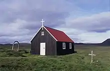
Krýsuvíkurkirkja
As all the estate farms in Iceland, Krýsuvík had its own small proprietary church, in this case from the 13th century till in 2010.
The last building was a 19th century timber church (built in 1857)[5] and used as a church till 1910. The church was then changed into an apartment building for some time after 1927. But in 1964, the then mayor of Hafnarfjörður, who was responsible for the area which is since then part of the city’s land, let renovate the church. From now on, the church was again used as such - and esp. very popular for weddings -, and placed under the protection of the National Museum[3] as part of the National Museum’s Buildings Collection.[5] Regrettably though, it burned down in January 2010.[3]
Krýsuvíkurskóli
Under the mountain Bæjarfell is now located a boarding school for young people who have problems with drug abuse.[6]
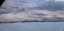
Interesting sites in the vicinity
.jpg.webp)
.jpg.webp)
There are some interesting places to visit in the region of Krýsuvík.
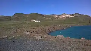
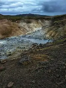
Maars and geothermal areas
In the vicinity are some maars and the high temperature geothermal area of Seltún, all part of the Krýsuvík volcanic system.
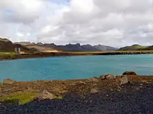
Lake Kleifarvatn
The biggest lake in the area, Kleifarvatn, began to diminish after a big earthquake in 2000; 20% of its surface had since disappeared up to 2005, but it had filled up again in 2019. Many interesting tuff rock formations are to be found at its western coast near Route 42 on the slopes of Sveifluháls.
Vegetation islands in a lava field: Ögmundarhraun
The Ögmundarhraun lava field from 1151, south of Krýsuvík, includes some kipukas, vegetation islands in the lava field, which can be reached by hiking trails. One of them, the Húshólmi, contains some ruins of the medieval farm of Krýsuvík.[7] Interestingly scientists around Haukur Jóhannesson identified some stone fences within the same kipuka as being older as the official time of settlement (874). They used tephrochronology and saw that the famous bimodal settlement tephra (landnámslagið) derived from a combined eruption series within the Bárðarbunga-Veiðivötn and Torfajökull systems in the years 871-874, was covering these structures.[8]
Bird cliffs at Krýsuvíkurbjarg
A jeep track runs down to the sea from Krýsuvík and Route 427. It ends at the high cliffs of Krýsuvíkurbjarg/Krýsuvíkurberg which are renowned as bird cliffs with thousands of Icelandic sea birds like arctic terns, puffins (fratercula arctica), fulmars and more.[3] About 63 000 pairs of birds were counted there shortly before 2014. But the cliffs, which can as well reached on foot, are also a window in the geologic past.[9] The lava flows covering the area came mostly from the crater up on Geitahlíð tuya, i.e. not from the Krýsuvík, but from the neighbouring Brennisteinsfjöll volcanic system. Krýsuvíkurbjarg or -berg is protected as part of Reykjanesfólkvangur.[10]
Hiking
Krýsuvík is a popular hiking area and tourism infrastructure — such as wooden pathways — has been developed.
Music video
The music video for the song "Never Forget" by Greta Salóme & Jónsi was filmed in this area.[11] This song also went to the Eurovision Song Contest 2012 in Baku, Azerbaijan and came 20th in the grand final.
| Wikimedia Commons has media related to Krýsuvík. |
References
- Ísland Vegaatlas. Reykjavík 2006, p. 1
- Snæbjörn Guðmundsson: Vegavísir um jarðfræði Íslands. Reykjavík 2015, p. 24
- Vegahandbókin. Ferðahandbókin þín. Landmælingar Íslands og Vegahandbókin. 2014, p. 213
- https://ferlir.is/krysuvik-althydublad-hafnarfjardar-1949/ Ferlir. Retrieved 2. August 2020.
- https://it.visiticeland.com/plan-your-trip/travel-search/search-results/view/krysuvik?type=place Krýsuvík in: Visit Iceland. Official Tourism Information Site. Retrieved 2 August 2020.
- Íslandshandbókin. Náttúra, saga of sérkenni. Reykjavík 1989, p. 55
- Reynir Ingibjartsson: 25 Gönguleiðir á Reykjanesskaga. Náttúrann við Bæjarveggin. Reykjavík 2014, p. 88-93
- Reynir Ingibjartsson: 25 Gönguleiðir á Reykjanesskaga. Náttúrann við Bæjarveggin. Reykjavík 2014, p. 88
- Reynir Ingibjartsson: 25 Gönguleiðir á Reykjanesskaga. Náttúrann við Bæjarveggin. Reykjavík , p. 94-99
- Reynir Ingibjartsson: 25 Gönguleiðir á Reykjanesskaga. Náttúrann við Bæjarveggin. Reykjavík , p. 99
- https://www.youtube.com/watch?v=p8RS0eulXDo Official preview video