Krýsuvík (volcanic system)
The volcanic system of Krýsuvík (or Krísuvík), also Krýsuvík-Trölladyngja volcanic system, is situated in the southwest of Iceland on the Reykjanes peninsula. It is to be found in the middle of Reykjanes and on the divergent plate boundary of the Mid-Atlantic Ridge which traverses Iceland. It was named after the Krýsuvík area which is part of it and consists of a fissure system without a central volcano.[1]
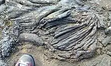
.jpg.webp)
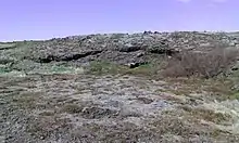
.jpg.webp)
The volcanic system has a length of 55 km, a width of around 13 km, covers an area of 350 km2 and its highest elevation is 393 m.[1]
Situation within the volcano-tectonic environment on Reykjanes
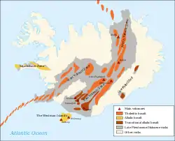
It is one of 4 (or up to 7, depending on author) volcanic systems situated within the Reykjanes Volcanic Belt.[2] The volcanic systems are arranged en echelon and in a certain angle (20 – 45°) to the rift zone of the divergent plate boundary traversing Reykjanes.
General characteristics
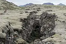
The volcanic system of Krýsuvík has no central volcano, but “a 50 km long, composite fissure swarm”,[3] i.e. a mixture of volcanic and tectonic fissures and faults, of which 30 km are volcanic fissures.[3] There are (state of knowledge in 2020) no submarine fissures of the system which nevertheless reaches from the south coast in direction SW to NE over the Reykjanes Peninsula. The northernmost fissures are thought to reach Rauðavatn lake in the outskirts of Reykjavík.
The Krýsuvík volcanic system has a tendency to effusive basaltic fissure eruptions and the last eruption took place in the 14th century.[4]
There are no ice-covered volcanoes connected to the Krýsuvík system, but lake Kleifarvatn lies within the system and geothermal activity is to be found at the lake bottom.[3]
The eruption products of the Krýsúvik system consist exclusively of basalt.[3]
Eruptions
The volcanic system is centered on the divergent plate boundary on Reykjanes peninsula. For magma, because of the multitude of tectonic and volcanic faults and fissures in such regions, it is easier there to reach the surface.[3]
In the whole, there are at least 10 volcanic episodes known within the volcanic system in the last 8000 years. These episodes comprised each many single eruptions and were most probably connected to rifting.[3]
Some Holocene eruptions have been dated specifically, esp. the eruption that produced Búrfellshraun (ca. 5290 BP).[4]
Since the time of settlement in Iceland, which is thought to have been in the 9th century, some more eruptions have taken place within the system, all of them in the Middle Ages.[4]
The activity of Pleistocene shield volcanoes such as Þráinskjöldur and Hrútagjá as well as of tuyas like Fagradalsfjall within the volcanic system is seen as “separate from the fissure system”,[3] though the bigger volcanoes control parts of the topography.[3]
The Krýsuvík system has a tendency to phreatic explosions, often within rifting episodes and/or eruption series. The reason being that the underground of Reykjanes peninsula is soaked with water (high groundwater level as well as saline sea water in cave systems ). There is especially the prehistoric maar complex around Grænavatn at Krýsuvík which has its origin in such explosions connected to a period of effusive eruptions.[5] There was also the explosion of an old borehole in 1999 at Seltún.[6][7]
Lava fields of the Krýsuvík volcanic system
There are some important lava fields to be named which originated in eruptions of the Krýsuvík volcanic system since the end of the last glacial spell (last 13 000 years).
Búrfellshraun
Around 8.000 years ago, the Búrfell crater near Hafnarfjörður, produced a lava field of important volume and which covers 18 km2 (for details see: Búrfell).[8]
Today, a big part of midtown Hafnarfjörður is built onto and around Búrfellshraun.[8]
Óbrinnishólabruni
These lavas came 2000 years ago from some craters near Bláfjallavegur (Road 407) which have since been destroyed by quarrying. The name Óbrinnishólar means that there was no “fire” in them during further eruptions in the region in historical time.[8]
Parts of Hafnarfjörður (midtown and Vallahverfi) are located on top of this lava field.[8]
Kapelluhraun
These lavas from historical time (erupted around 1150)[8] have been given this name because of a medieval chapel whose ruins are still standing on them. A small statue of Saint Barbara was found at the place.[9]
The Kapelluhraun lava field consists of pāhoehoe and ʻaʻā lava which streamed from the highland down to the bay of Straumsvík near today’s aluminium smelter and there into the sea. [8]
At the same time when these lavas erupted from craters of the Krýsuvík volcanic system at Vatnsskarð (Kleifarvatn), now mostly disappeared because of a quarry, and long eruption fissures, there were many and heavy earthquakes as medieval sources report (Flateyjarbók).[8]
The eruption fissures had a length of 10 km and 6,5 km respectively, and the lava flows cover around 36 km2.[8]
The events were part of a ca. 30 years long unrest period in the late 12th century which is called Krýsuvík Fires. This unrest period included repeated eruption series and rifting episodes.[8]
Today a golf course[10] is situated in the middle of these lavas, well to be seen when looking from road 41 between Straumsvík and Hafnarfjörður in direction of Faxaflói.
Craters, volcanic mountains and other volcanic landforms
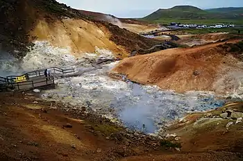
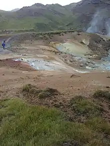
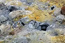
Seltún geothermal area
This area is situated next to Krýsuvík in direction of lake Kleifarvatn (Route 42) and at the foot of Sveifluháls hyaloclastite ridge.
It is a geothermal high temperature area,[6] hydrothermal alteration has led to a multicolored environment. Here solfataras, fumaroles, mud pots and hot springs are formed, the soil is coloured bright yellow, red, and green caused by iron oxidation, sulfur and calcite precipitation.
The sulfur deposits were mined in 1722–1728 and in the 19th century. German scientist Robert Bunsen visited the site in 1845 and, based on research there, proposed a hypothesis on formation of sulphuric acid in nature.[11]
The area can be visited on footpaths. A small hut provides services to the traveler.
Other volcanic landforms within the Krýsuvík volcanic system
Within the area of the Krýsuvík volcanic system are also to be found e.g. the pyroclastic cone Búrfell (Hafnarfjörður) with its famous lava channel Búrfellsgjá, the Ögmundarhraun lava field from the 12th century as well as some Pleistocene subglacial mounds and formations like Helgafell (Hafnarfjörður), Sveifluháls and Trölladyngja (Reykjanes).
Current situation
Some active geothermal high temperature areas are to be found in the system, especially at Seltún.
In the last years, repeated uplift episodes and earthquake series could be seen, probably connected to igneous intrusions. This took place esp. in Fagradalsfjall, which “is sometimes considered a separate volcanic system”.[3] This means it is attributed its own magma chamber by some scientists.
| Wikimedia Commons has media related to Krýsuvík (volcanic system). |
See also
- Brennisteinsfjöll volcanic system
- Reykjanes peninsula (Reykjanesskagi)
- Reykjanes Volcanic Belt
External links
General information
- http://icelandicvolcanos.is/?volcano=KRI Krýsuvík. Catalogue of Icelandic Volcanoes.
- https://volcano.si.edu/volcano.cfm?vn=371030 Krýsuvík. Global Volcanism Program. Smithsonian Institution.
Volcano monitoring
- Icelandic Met Office (IMO). Earthquake Monitoring. Reykjanes Peninsula
- IMO. Aviation Color Code
- Geologist Páll Einarsson explains geology and volcanism of Reykjanes Peninsula as well as the 2020 earthquake series which partially takes place within this volcanic system. RÚV. 20 October 2020. (in Icelandic)
References
- Thorvaldur Thordarson, Ármann Höskuldsson: Postglacial volcanism in Iceland. Jökull No. 58 (2008). Retrieved 20 August 2020.
- Thorvaldur Thordarson and Ármann Höskuldsson: Postglacial volcanism in Iceland, Jökull no. 58, 2008. Retrieved 2 August 2020. (System no. 2 on the maps and tables)
- Krýsuvík. Catalogue of Icelandic Volcanoes. Retrieved 2 August 2020.
- https://volcano.si.edu/volcano.cfm?vn=371030 Krýsuvík. Global Volcanism Program. Smithsonian Institution. Retrieved 2 August 2020.
- Thor Thordarson, Armann Hoskuldsson: Iceland. Classic geology of Europe 3. Harpenden 2002, p.70
- https://en.isor.is/17-seltun-high-temperature-area-solfataras Seltún - High temperature area with solfataras. ÍSOR. Retrieved 2.August 2020.
- https://www.mbl.is/greinasafn/grein/1355609/ Borhola við Seltún spýtti úr sér. Morgunbaðið, 8. Nóvember 2010. Retrieved 2 August 2020
- Daníel Páll Jónasson: Hraunflæði á höfuðborgarsvæðinu. Saga hraunflæðis á svæðinu á nútíma og kortlagning mögulegra farvega til byggða. BS ritgerð. Leiðbeinandi Ármann Höskuldsson. Líf- og umhverfisvísindadeild Háskóli Íslands 2012 (in Icelandic, abstract also in English). Retrieved 12 August 2020.
- Íslandshandbókin. Náttúra, saga og sérkenni. Reykjavík 1989, p. 82
- https://www.hole19golf.com/iceland/golfklubburinn-keilir-hvaleyrarvollur Golf club Keilir, Hafnarfjörður. Retrieved 17 August 2020.
- "Krýsuvík – Seltún geothermal area". Wondermondo.