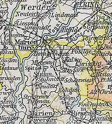
Kreis Stuhm
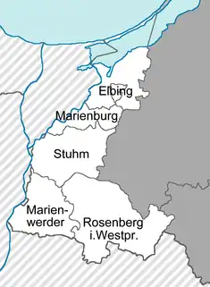
The Stuhm district was a Prussian district that existed between 1818 and 1945. It belonged to the part of West Prussia that remained in the German Reich after World War I and was since part of the province of East Prussia. Today, the territory of the district is located in the Pomeranian Voivodeship in Poland.
History
The area of the Stuhm district was annexed by Prussia during the First Partition of Poland in 1772 and belonged to the Marienburg district until 1818.[1] As part of a comprehensive district reform in the province of West Prussia, the new Stuhm district was formed on April 1, 1818 from the southern part of the Marienburg district. It comprised the towns of Christburg and Stuhm.[2]
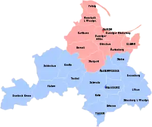
From December 3, 1829 to April 1, 1878, West Prussia and East Prussia were united to form the Province of Prussia, which became part of the German Empire in 1871. With the entry into force of the Treaty of Versailles on January 10, 1920 and the associated dissolution of the Province of West Prussia, the Stuhm district was initially subordinated to the Oberpräsident in Königsberg. In preparation for the referendum on the future membership of the district, it was subordinated to the Inter-Allied Commission for Government and Referendum in Marienwerder. In the referendum on July 1, 1920, 80 percent of the voters in the Stuhm district decided that the district would remain in the German Reich. On July 1, 1922, the Stuhm district was incorporated into the province of East Prussia. Regierungsbezirk Marienwerder was renamed Regierungsbezirk Westpreußen for reasons of tradition.
On September 1, 1924, the rural communities of Tessensdorf and Willenberg were transferred from the Stuhm district to the Marienburg district and were incorporated into the town of Marienburg. After the invasion of Poland in 1939, the Stuhm district became part of the newly formed Reichsgau Danzig-West Prussia. In spring 1945, the Red Army conquered the district and in April 1945 it was placed under the administration of the Polish People's Republic.
Demogrpahics
| 1837 | 1849 | 1855 | 1867 | |||||
|---|---|---|---|---|---|---|---|---|
| Germans | 15,512 | 54.4% | 18,941 | 54.6% | 21,932 | 57.7% | 23,555 | 58.2% |
| Poles | 13,024 | 45.6% | 15,777 | 45.4% | 16,104 | 42.3% | 16,928 | 41.8% |
| Total | 28,536 | 34,718 | 38,036 | 40,483 | ||||
Municipalities
Prior to its dissolution in 1945, the district comprised two towns and 65 other municipalities:[4]
|
|
|
|
Place names
In some cases, place names that were considered "not German" enough in the 1930s received phonetic alignment or translation:
- Barlewitz → Wargels
- Czewskawolla → Petersbruch
- Jordanken → Jordansdorf
- Kollosomp → Kalsen
- Kommerau → Kammerau
- Mlecewo → Heinrode
- Nikolaiken → Niklaskirchen
- Sadluken → Sadlacken
- Straszewo → Dietrichsdorf
- Watkowitz → Wadkeim
References
- Goldbeck, Johann Friedrich (1789). Volständige Topographie des Königreichs Preussen (in German). Auf eigene Kosten und in eignem Verlage.
- Töppen, Max (1858). Historisch-comparative Geographie von Preussen: Nach den Quellen, Namentlich auch Archivalischen (in German). J. Perthes.
- Belzyt, Leszek (1998). Sprachliche Minderheiten im preussischen Staat: 1815 - 1914 ; die preußische Sprachenstatistik in Bearbeitung und Kommentar. Marburg: Herder-Inst. ISBN 978-3-87969-267-5.
- "Deutsche Verwaltungsgeschichte Westpreussen, Kreis Stuhm". treemagic.org. Retrieved 2021-01-18.