Kuchinoerabu-jima
Kuchinoerabu-jima (口永良部島), is one of the Satsunan Islands, usually classed with the Ōsumi Islands belonging to Kagoshima Prefecture, Japan. The island, 38.04 km² in area, has a population of 147. The island can only be reached by boat as it has no airport. There is regular ferry service with Yakushima, which is about 15 km to the east. Travel time is approximately 1 hour. The islanders are dependent mainly on fishing, agriculture and seasonal tourism. The entire island is within the borders of the Kirishima-Yaku National Park.
| Native name: Japanese: 口永良部島 | |
|---|---|
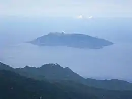 Kuchinoerabu-jima from Nagatadake on Yakushima | |
 | |
| Geography | |
| Location | East China Sea |
| Coordinates | 30°28′N 130°11′E |
| Archipelago | Ōsumi Islands |
| Area | 38.04 km2 (14.69 sq mi) |
| Length | 12 km (7.5 mi) |
| Width | 5 km (3.1 mi) |
| Coastline | 49.67 km (30.864 mi) |
| Highest elevation | 657 m (2156 ft) |
| Highest point | Furudake |
| Administration | |
| Kagoshima Prefecture | |
| Demographics | |
| Population | 147 (2010) |
| Ethnic groups | Japanese |
| Additional information | |
| Last eruption date 2020 | |
Geography
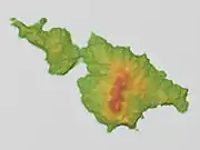
Kuchinoerabu-jima is located 130 kilometres (70 nmi) south of Kagoshima. The island is of volcanic origin, and has an area of approximately 38 square kilometres (15 sq mi) with a length of 12 kilometres (7.5 mi) and width of 5 kilometres (3.1 mi). The highest elevations on the island are Furudake (古岳), with a height of 657 metres (2,156 ft) and Shindake (新岳), with a height of 640 metres (2,100 ft) above sea level. There are numerous hot springs on the island.
.jpg.webp)
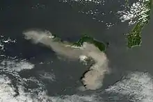
The island is an active volcano which has erupted several times during the modern period, including 24 December 1933, when several people were killed when lava masses buried several villages. In 1980, multiple explosion craters appeared along an 800-metre (2,600 ft) north-south fissure on the slope east of Shindake. Shindake erupted again on 4 August 2014, generating a pyroclastic flow, but with no injuries or fatalities.[1] The main crater erupted on the morning of 29 May 2015, prompting a level 5 alert level and the evacuation of the island.[2]
The island’s climate is classified as subtropical, with a rainy season from May through September.
History
During the Edo period, Kuchinoerabu-jima was ruled by the Shimazu clan of Satsuma Domain and was considered part of Ōsumi Province. Following the Meiji restoration, it was administered as Kuchinoerabujima Village, which encompassed part of Yakushima. It is now part of the city of Yakushima, Kagoshima.
Kuchinoerabu-jima is the last known location of missing American poet Craig Arnold, who was visiting the island in April 2009, doing research for a book on volcanos.[3]
Volcanic eruptions of Mount Shindake
On May 18, 2015 Japanese scientists detected increased seismic activity and steam rising from the Shindake's crater, and on May 29, 2015 an eruption sent an ash cloud an estimated 30,000 feet (9,100 meters) into the sky.[4] No deaths and only one minor injury were reported by the Japanese government. The island’s 140 residents were evacuated by Japan’s coast guard. Previous eruptions occurred in August, 2014 and in 1980.[5][6][7]
Shindake crater erupted on December 18, 2018, ejecting an ash cloud 2 kilometers into above cloud coverage.[8] Thirty days later on January 17, 2019, Shindake erupted again, sending pyroclastic flows 1.5 kilometers to the southwest and northwest of the crater as well as an ash cloud 6 kilometers into the atmosphere.[9]
References
- "Kuchinoerabu-Jima volcano (Ryukyu Islands, Japan): new eruption and pyroclastic flow". www.volcanodiscovery.com. Volcano Discovery site.
- "Volcano explodes off Kyushu, forcing small island to evacuate". The Japan Times.
- "US poet missing on Japan volcano". BBC News. 1 May 2009.
- "RAW: Volcano erupts in Japan, spews plume of ash and smoke into sky". 28 May 2015.
- Howard, Brian Clark; 29, National Geographic PUBLISHED May. "Scary Beautiful Video Captures Japan Volcano's Violent Explosion". National Geographic News. Retrieved 2015-05-31.CS1 maint: numeric names: authors list (link)
- "Volcano in Kagoshima erupts for 1st time in 34 years, no injuries reported - AJW by The Asahi Shimbun". AJW by The Asahi Shimbun. Archived from the original on 2015-05-31. Retrieved 2015-05-31.
- "Japan volcano eruption triggers highest alert, locals' evacuation (VIDEO)". Retrieved 2015-05-31.
- "Volcano in southwestern Japan erupts, residents advised to evacuate - Xinhua | English.news.cn". www.xinhuanet.com. Retrieved 2019-01-17.
- "Volcano erupts on Kyushu isle, pyroclastic flows extend 1.5 km:The Asahi Shimbun". The Asahi Shimbun. Retrieved 2019-01-17.
Further reading
External links
| Wikimedia Commons has media related to Kuchinoerabujima. |
- Yakushima town official website
- Kuchinoerabujima - Japan Meteorological Agency (in Japanese)
- "Kuchinoerabujima: National catalogue of the active volcanoes in Japan" (PDF). - Japan Meteorological Agency
- Kuchinoerabujima Volcano - Geological Survey of Japan
- "Kuchinoerabujima". Global Volcanism Program. Smithsonian Institution.
| Authority control |
|---|
