Kumakōgen, Ehime
Kumakōgen (久万高原町, Kumakōgen-chō) is a town in Kamiukena District, Ehime Prefecture, Japan.
Kumakōgen
久万高原町 | |||||||||||
|---|---|---|---|---|---|---|---|---|---|---|---|
Town | |||||||||||
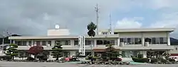 Kumakogen town hall | |||||||||||
 Flag  Emblem | |||||||||||
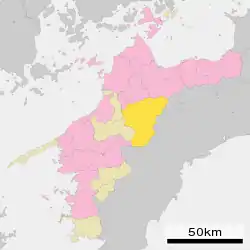 Location of Kumakōgen in Ehime Prefecture | |||||||||||
 Kumakōgen Location in Japan | |||||||||||
| Coordinates: 33°39′N 132°54′E | |||||||||||
| Country | Japan | ||||||||||
| Region | Shikoku | ||||||||||
| Prefecture | Ehime Prefecture | ||||||||||
| District | Kamiukena | ||||||||||
| Government | |||||||||||
| • Mayor | Muneki Takano (since September 2008) | ||||||||||
| Area | |||||||||||
| • Total | 583.66 km2 (225.35 sq mi) | ||||||||||
| Population (April 30, 2017) | |||||||||||
| • Total | 8,660 | ||||||||||
| • Density | 15/km2 (38/sq mi) | ||||||||||
| Time zone | UTC+09:00 (JST) | ||||||||||
| City hall address | 212 Kuma, Kumakōgen-chō, Kamiukena-gun, Ehime-ken 791-1201 | ||||||||||
| Website | www | ||||||||||
| |||||||||||
The town was formed on August 1, 2004 from the merger of the town of Kuma, and the villages of Mikawa, Omogo and Yanadani, all from Kamiukena District.
As of April 30, 2017, the town has an estimated population of 8,660, with 4,561 households and a population density of 15 persons per km².[1] The total area is 583.66 km².
Geography
Mount Ishizuchi, the tallest mountain in Shikoku at 1982 m is located on the border between Seiyo to the northeast. Because the town is very mountainous, settlements are located along the Omogo River (Niyodo River). The climate is cool and wet in the summer and winters cold with snow.[2]
Neighbouring municipalities
References
- "Official website of Kumakōgen Town" (in Japanese). Japan: Kumakōgen Town. Archived from the original on 4 February 2005. Retrieved 27 May 2017.
- 考える社会科地図 Kangaeru Shakaika Chizu. 四谷大塚出版 Yotsuya-Ōtsuka Shuppan. 2005. p. 113.
External links
| Wikimedia Commons has media related to Kumakogen, Ehime. |
- Official website
 (in Japanese)
| Core city | ||
|---|---|---|
| Cities | ||
| Districts | ||
| Authority control |
|---|
This article is issued from Wikipedia. The text is licensed under Creative Commons - Attribution - Sharealike. Additional terms may apply for the media files.