Kurumkansky District
Kurumkansky District (Russian: Курумка́нский райо́н; Buryat: Хурамхаанай аймаг, Khuramkhaanai aimag) is an administrative[1] and municipal[6] district (raion), one of the twenty-one in the Republic of Buryatia, Russia. It is located in the northeast of the republic. The area of the district is 12,450 square kilometers (4,810 sq mi).[3] Its administrative center is the rural locality (a selo) of Kurumkan.[1] As of the 2010 Census, the total population of the district was 15,007, with the population of Kurumkan accounting for 36.4% of that number.[4]
Kurumkansky District
Курумканский район | |
|---|---|
| Other transcription(s) | |
| • Buryat | Хурамхаанай аймаг |
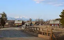 Village (selo) Baraghan, Kurumkansky District | |
 Flag  Coat of arms | |
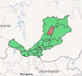
Location of Kurumkansky District in the Buryat Republic | |
| Coordinates: 54°19′N 110°19′E | |
| Country | Russia |
| Federal subject | Republic of Buryatia[1] |
| Established | December 11, 1970[2] |
| Administrative center | Kurumkan[1] |
| Area | |
| • Total | 12,450 km2 (4,810 sq mi) |
| Population | |
| • Total | 15,007 |
| • Estimate (2018)[5] | 13,599 (−9.4%) |
| • Density | 1.2/km2 (3.1/sq mi) |
| • Urban | 0% |
| Administrative structure | |
| • Administrative divisions | 5 Selsoviets, 4 Somons |
| • Inhabited localities[1] | 28 Rural localities |
| Municipal structure | |
| • Municipally incorporated as | Kurumkansky Municipal District[6] |
| • Municipal divisions[6] | 0 Urban settlements, 10 Rural settlements |
| Time zone | UTC+8 (MSK+5 |
| OKTMO ID | 81630000 |
| Website | http://kurumkan.burnet.ru |
| 2010 Census | 15,007[4] |
|---|---|
| 2002 Census | 16,235[8] |
| 1989 Census | 18,852[9] |
| 1979 Census | 17,928[10] |
History
The district was established on December 11, 1970.[2]

Administrative and municipal status
Within the framework of administrative divisions, Kurumkansky District is one of the twenty-one in the Republic of Buryatia.[1] The district is divided into five selsoviets and four somons, which comprise twenty-eight rural localities.[1] As a municipal division, the district is incorporated as Kurumkansky Municipal District.[6] Its five selsoviets and four somons are incorporated as ten rural settlements within the municipal district.[6] The selo of Kurumkan serves as the administrative center of both the administrative[1] and municipal[6] district.
References
Notes
- Resolution #431
- Official website of the Buryat Republic. Kurumkansky District, History (in Russian)
- Official website of the Buryat Republic. Information about Kurumkansky District Archived May 28, 2012, at the Wayback Machine (in Russian)
- Russian Federal State Statistics Service (2011). "Всероссийская перепись населения 2010 года. Том 1" [2010 All-Russian Population Census, vol. 1]. Всероссийская перепись населения 2010 года [2010 All-Russia Population Census] (in Russian). Federal State Statistics Service.
- "26. Численность постоянного населения Российской Федерации по муниципальным образованиям на 1 января 2018 года". Federal State Statistics Service. Retrieved January 23, 2019.
- Law #985-III
- "Об исчислении времени". Официальный интернет-портал правовой информации (in Russian). June 3, 2011. Retrieved January 19, 2019.
- Russian Federal State Statistics Service (May 21, 2004). "Численность населения России, субъектов Российской Федерации в составе федеральных округов, районов, городских поселений, сельских населённых пунктов – районных центров и сельских населённых пунктов с населением 3 тысячи и более человек" [Population of Russia, Its Federal Districts, Federal Subjects, Districts, Urban Localities, Rural Localities—Administrative Centers, and Rural Localities with Population of Over 3,000] (XLS). Всероссийская перепись населения 2002 года [All-Russia Population Census of 2002] (in Russian).
- "Всесоюзная перепись населения 1989 г. Численность наличного населения союзных и автономных республик, автономных областей и округов, краёв, областей, районов, городских поселений и сёл-райцентров" [All Union Population Census of 1989: Present Population of Union and Autonomous Republics, Autonomous Oblasts and Okrugs, Krais, Oblasts, Districts, Urban Settlements, and Villages Serving as District Administrative Centers]. Всесоюзная перепись населения 1989 года [All-Union Population Census of 1989] (in Russian). Институт демографии Национального исследовательского университета: Высшая школа экономики [Institute of Demography at the National Research University: Higher School of Economics]. 1989 – via Demoscope Weekly.
- "Всесоюзная перепись населения 1979 г. Национальный состав населения по регионам России" [All Union Population Census of 1979. Ethnic composition of the population by regions of Russia] (XLS). Всесоюзная перепись населения 1979 года [All-Union Population Census of 1979] (in Russian). 1979 – via Demoscope Weekly (website of the Institute of Demographics of the State University—Higher School of Economics.
Sources
- Правительство Республики Бурятия. Постановление №431 от 18 ноября 2009 г. «О реестре административно-территориальных единиц и населённых пунктов Республики Бурятия», в ред. Постановления №573 от 13 ноября 2015 г. «О внесении изменений в Постановление Правительства Республики Бурятия от 18.11.2009 №431 "О реестре административно-территориальных единиц и населённых пунктов Республики Бурятия"». Вступил в силу 18 ноября 2009 г. Опубликован: "Бурятия", №216, Официальный вестник №120, 21 ноября 2009 г. (Government of the Republic of Buryatia. Resolution #431 of November 18, 2009 On the Registry of the Administrative-Territorial Units and the Inhabited Localities of the Republic of Buryatia, as amended by the Resolution #573 of November 13, 2015 On Amending Resolution #431 of November 18, 2009 of the Government of the Republic of Buryatia "On the Registry of the Administrative-Territorial Units and the Inhabited Localities of the Republic of Buryatia". Effective as of November 18, 2009.).
- Народный Хурал Республики Бурятия. Закон №985-III от 31 декабря 2004 г. «Об установлении границ, образовании и наделении статусом муниципальных образований в Республике Бурятия», в ред. Закона №1411-V от 14 октября 2015 г. «О внесении изменений в Закон Республики Бурятия "Об установлении границ, образовании и наделении статусом муниципальных образований в Республике Бурятия"». Вступил в силу со дня официального опубликования. Опубликован: "Бурятия", №1, Официальный вестник №1, 12 января 2005 г. (People's Khural of the Republic of Buryatia. Law #985-III of December 31, 2004 On Establishing the Borders, Creating, and Granting a Status to the Municipal Formations in the Republic of Buryatia, as amended by the Law #1411-V of October 14, 2015 On Amending the Law of the Republic of Buryatia "On Establishing the Borders, Creating, and Granting a Status to the Municipal Formations in the Republic of Buryatia". Effective as of the day of the official publication.).
Administrative divisions of the Republic of Buryatia | |||
|---|---|---|---|
Capital: Ulan-Ude • Rural localities | |||
| Districts | |||
| Cities and towns (all levels) | |||
| Urban-type settlements | |||
