Kusong
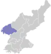
Kusŏng (Korean pronunciation: [ku.sʌŋ]) is a city in central North Pyongan province, North Korea. It borders Taegwan to the north, Taechon to the east, Kwaksan and Chongju to the south, and Chonma to the west. The highest point is Chongryongsan (청룡산, 920 m). The year-round average temperature is 8.2 °C, with a January average of -9.6 °C and an August average of 23.3 °C. 1300 millimeters of rain fall in a typical year. 22% of the county's area is cultivated; 64% is forested.
Kusong
구성시 | |
|---|---|
| Korean transcription(s) | |
| • Chosŏn'gŭl | 구성시 |
| • Hancha | 龜城市 |
| • McCune-Reischauer | Kusŏng si |
| • Revised Romanization | Guseong-si |
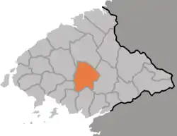 Map of North Pyongan showing the location of Kusong | |
| |
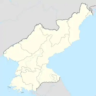 Kusong Location within North Korea | |
| Coordinates: 39°58′N 125°10′E | |
| Country | North Korea |
| Province | North Pyongan Province |
| Administrative divisions | 24 tong, 18 ri |
| Area | |
| • Total | 666.8 km2 (257.5 sq mi) |
| Population (2008) | |
| • Total | 196,515 |
| • Dialect | P'yŏngan |
| Time zone | UTC+9 (Pyongyang Time) |
Educational institutions located in Kusong include Kusong Mechanical College and Kusong Industrial College. Historical relics include the Koryo-dynasty Kuju Castle.
Kusong is also home to much of North Korea's military industry, with both munitions factories and uranium mines in the area.[1] The Panghyon airfield is also located by Kusong,[2] which is a site of missile test launches, including the first successful ICBM test launch by N.K.[2]
Climate
| Climate data for Kusong (1981–2010) | |||||||||||||
|---|---|---|---|---|---|---|---|---|---|---|---|---|---|
| Month | Jan | Feb | Mar | Apr | May | Jun | Jul | Aug | Sep | Oct | Nov | Dec | Year |
| Average high °C (°F) | −1.5 (29.3) |
2.1 (35.8) |
8.2 (46.8) |
16.5 (61.7) |
22.7 (72.9) |
26.5 (79.7) |
28.0 (82.4) |
29.1 (84.4) |
25.2 (77.4) |
18.5 (65.3) |
8.1 (46.6) |
0.8 (33.4) |
15.4 (59.7) |
| Daily mean °C (°F) | −7.5 (18.5) |
−3.7 (25.3) |
2.4 (36.3) |
9.8 (49.6) |
16.1 (61.0) |
20.9 (69.6) |
23.6 (74.5) |
24.0 (75.2) |
18.8 (65.8) |
11.4 (52.5) |
2.5 (36.5) |
−4.7 (23.5) |
9.5 (49.1) |
| Average low °C (°F) | −12.7 (9.1) |
−9.1 (15.6) |
−2.9 (26.8) |
3.6 (38.5) |
10.2 (50.4) |
16.1 (61.0) |
20.2 (68.4) |
20.0 (68.0) |
13.6 (56.5) |
5.8 (42.4) |
−2.2 (28.0) |
−9.0 (15.8) |
4.5 (40.1) |
| Average precipitation mm (inches) | 11.3 (0.44) |
16.4 (0.65) |
26.2 (1.03) |
59.9 (2.36) |
82.3 (3.24) |
129.8 (5.11) |
344.7 (13.57) |
297.8 (11.72) |
87.9 (3.46) |
52.7 (2.07) |
43.6 (1.72) |
17.2 (0.68) |
1,169.8 (46.06) |
| Average precipitation days (≥ 0.1 mm) | 3.4 | 3.7 | 4.8 | 6.8 | 8.9 | 10.1 | 14.7 | 10.9 | 6.8 | 6.5 | 6.9 | 5.2 | 88.7 |
| Average snowy days | 4.7 | 3.9 | 3.1 | 0.5 | 0.0 | 0.0 | 0.0 | 0.0 | 0.0 | 0.1 | 2.0 | 4.7 | 19.0 |
| Average relative humidity (%) | 64.6 | 61.5 | 62.0 | 63.9 | 68.8 | 75.3 | 83.8 | 81.5 | 74.6 | 69.8 | 68.3 | 66.2 | 70.0 |
| Source: Korea Meteorological Administration[3] | |||||||||||||
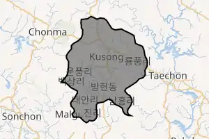
Administrative divisions
The city is divided into 25 neighborhoods (dong) and 18 villages (ri).
|
|
Footnotes
- Pike, John. "Kusong - North Korean Special Weapons Facilities". www.globalsecurity.org.
- Choe, Sang-hun (July 4, 2017). "North Korea Claims Success in Long-Range Missile Test". The New York Times. USA. Archived from the original on July 4, 2017. Retrieved July 4, 2017.
- "30 years report of Meteorological Observations in North Korea" (in Korean). Korea Meteorological Administration. pp. 232–281. Archived from the original on 21 December 2020. Retrieved 25 December 2020.
References
- International Information Research Institute (국제정보연구소) (1999). "구성시". 北韓情報總覽 2000 [Bukhan jeongbo chong-ram 2000]. Seoul: Author. pp. 835–836.
- http://nk.joins.com/map/view.asp?idx=i061.htm
Further reading
- Dormels, Rainer. North Korea's Cities: Industrial facilities, internal structures and typification. Jimoondang, 2014. ISBN 978-89-6297-167-5
External links
- (in Korean) In Korean language online encyclopedias:
- City profile of Kusong