Kyritz
Kyritz (German pronunciation: [ˈkyːʁɪts]) is a town in the Ostprignitz-Ruppin district, in Brandenburg, Germany. It is situated 28 km west of Neuruppin and 28 km southeast of Pritzwalk.

Saint Mary’s church
Kyritz | |
|---|---|
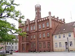 Town hall | |
 Coat of arms | |
Location of Kyritz within Ostprignitz-Ruppin district  | |
 Kyritz  Kyritz | |
| Coordinates: 52°57′00″N 12°24′00″E | |
| Country | Germany |
| State | Brandenburg |
| District | Ostprignitz-Ruppin |
| Subdivisions | Kyritz and 12 town districts |
| Government | |
| • Mayor | Nora Görke (Ind.) |
| Area | |
| • Total | 156.09 km2 (60.27 sq mi) |
| Elevation | 42 m (138 ft) |
| Population (2019-12-31)[1] | |
| • Total | 9,260 |
| • Density | 59/km2 (150/sq mi) |
| Time zone | UTC+01:00 (CET) |
| • Summer (DST) | UTC+02:00 (CEST) |
| Postal codes | 16866 |
| Dialling codes | 03 39 71 |
| Vehicle registration | OPR, KY, NP, WK |
| Website | www.kyritz.de |
There are 9,900 inhabitants (2007).
Overview
The town is situated near the Kyritzer Seenkette, a chain of lakes. The town is nicknamed "Kyritz an der Knatter" (Kyritz at the Rattle). The noise of numerous water mills along a stream parallel to the river Jäglitz was the reason for this nickname. This river channel does not exist anymore.
The town includes the districts Berlitt, Bork, Drewen, Gantikow, Ganz, Holzhausen, Kötzlin, Lellichow, Mechow, Rehfeld and Teetz.
History
- In the year 946 Kyritz was first mentioned in writing.
- In the year 1225 a Franciscan friary was established here (dissolved in 1552)
- In the year 1237 Kyritz (originally Chorizi) received the Stendal town right. The town is situated in the area Prignitz, Slavic pregynica (means "inaccessible woods").
- In the 14th century Kyritz became a member of the Hanse. At this time the parish church St. Marien and the city wall were built. The church and rests of the city wall are still existing today.
- In the year 1488 the first Kyritzer Beer named "Mord und Totschlag" (Murder and Manslaughter) was brewed. The Beer is still brewed in Neuzelle.
- In 1600 count Hans Christoff von Königsmarck was born, a leading Swedish general in the Thirty Years' War who is most famous for conquering Prague in 1648.
- In the year 1626 800 Kyritzer people died due to the bubonic plague.
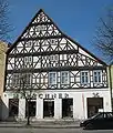
- In the 17th and 18th century half-timbered houses were built which still dominate the town center.
- From 1806 to 1814 French occupation. In 1814 the "Peace oak" was planted which is still on the market place in front of the town hall.
Demography
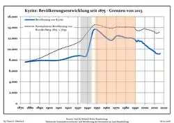 Development of population since 1875 within the current Boundaries (Blue Line: Population; Dotted Line: Comparison to Population development in Brandenburg state; Grey Background: Time of Nazi Germany; Red Background: Time of communist East Germany)
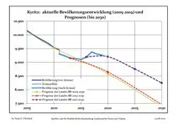 Recent Population Development and Projections (Population Development before Census 2011 (blue line); Recent Population Development according to the Census in Germany in 2011 (blue bordered line); Official projections for 2005-2030 (yellow line); for 2014-2030 (red line); for 2017-2030 (scarlet line)
|
|
|
Photogallery
- Fountain


 Marketplace
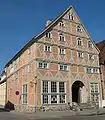
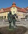
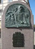
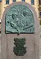
 Memorial stone
References
- "Bevölkerung im Land Brandenburg nach amtsfreien Gemeinden, Ämtern und Gemeinden 31. Dezember 2019". Amt für Statistik Berlin-Brandenburg (in German). July 2020.
- Detailed data sources are to be found in the Wikimedia Commons.Population Projection Brandenburg at Wikimedia Commons
External links
![]() Media related to Kyritz at Wikimedia Commons
Media related to Kyritz at Wikimedia Commons
Towns and municipalities in Ostprignitz-Ruppin | ||
|---|---|---|
Coat of Arms of Ostprignitz-Ruppin district | ||
| Authority control |
|---|
This article is issued from Wikipedia. The text is licensed under Creative Commons - Attribution - Sharealike. Additional terms may apply for the media files.