La Grande River
La Grande River (French: La Grande Rivière, Cree: Chisasibi, both meaning "great river") is a river in northwestern Quebec, Canada, which rises in the highlands of north central Quebec and flows roughly 900 kilometres (560 mi) west to drain into James Bay. It is the second largest river in Quebec, surpassed only by the Saint Lawrence River.
| La Grande River | |
|---|---|
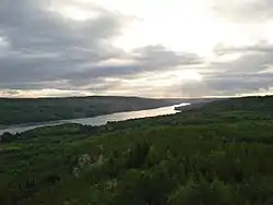 La Grande River near Radisson, Quebec. | |
 La Grande River original basin in yellow. Diverted basins in orange. | |
| Location | |
| Country | Canada |
| Province | Quebec |
| Region | Jamésie |
| Physical characteristics | |
| Source | Lac Nichicun |
| • location | Nitchequon |
| • coordinates | 53°12′30″N 70°56′00″W |
| Mouth | James Bay |
• location | Chisasibi |
• coordinates | 53°50′00″N 79°04′00″W |
• elevation | 0 m (0 ft) |
| Length | 893 km (555 mi)[1] |
| Basin size | 97,600 km2 (37,700 sq mi)[1] |
| Discharge | |
| • average | 3,400 m3/s (120,000 cu ft/s)[2] |
| • minimum | 345 m3/s (12,200 cu ft/s) |
| • maximum | 4,450 m3/s (157,000 cu ft/s) |
Originally, the La Grande River drained an area of 97,400 square kilometres (37,600 sq mi) and had a mean discharge of 1,690 m3/s (60,000 cu ft/s).[1] Since the 1980s when hydroelectric development diverted the Eastmain and Caniapiscau rivers into the La Grande, its total catchment area has increased to about 175,000 square kilometres (68,000 sq mi), and its mean discharge increased to more than 3,400 m3/s (120,000 cu ft/s).[2] In November 2009, the Rupert River was also partially diverted, adding another 31,430 square kilometres (12,140 sq mi) to the basin.
At one time, this river was known as the "Fort George River". The Hudson's Bay Company operated a trading post on the river at Big River House from 1803 to 1824. In 1837, a large trading post was established at Fort George on an island at the mouth of the river. In the early 20th century, this trading post became a village as the Crees of the James Bay region abandoned their nomadic way of life and settled nearby. The modern Cree village of Chisasibi, which replaced Fort George in 1980, is situated on the southern shore of the La Grande River, several kilometers to the East.
Tributaries
Significant tributaries of La Grande River include:
- Kanaaupscow River
- Sakami River
- Eastmain River (diverted)
- Opinaca River
- Rupert River (diverted)
- Eastmain River (diverted)
- Rivière de Pontois
- Rivière de la Corvette
- Laforge River
- Caniapiscau River (diverted)
Hydro-electric development
The river has been extensively developed as a source of hydroelectric power by Hydro-Québec, starting in 1974. An area of 9,900 square kilometres (3,800 sq mi) was flooded and almost all of the flow of the Eastmain River and a large portion of the Rupert River were diverted into the La Grande watershed. The following generating stations are on the La Grande River and its tributaries in upstream order:
- La-Grande-1 (LG-1)
- Robert-Bourassa
- La Grande-2A (LG-2A)
- La Grande-3 (LG-3)
- La Grande-4 (LG-4)
- Laforge-1 (LF-1)
- Laforge-2 (LF-2)
- Brisay
- Eastmain-1
As a result of the development projects, the Cree people of the region lost some parts of their traditional hunting and trapping territories (about 10% of the hunting and trapping territories used by the Cree of Chisasibi). Organic mercury levels increased in the fish, which forms an important part of their diet, as the organic material trapped by the rising waters in the new reservoirs began to filter into the food chain. Careful follow-up by Cree health authorities since the 1980s has been largely successful. The authorities continue to promote the regular consumption of fish, with the notable exception of the predatory species living in the reservoirs, which still show high levels of mercury.
References
- Atlas of Canada Archived 2007-04-10 at the Wayback Machine (all values of original river prior to hydro-electric development.)
- Hydro-Québec and GENIVAR Groupe Conseil inc., Environmental Monitoring of the La Grande-2-A and La Grande-1 Projects. Abridged Summary Report 1987-2000. La Grande Winter plume. July 2005 (Online version Archived 2011-06-05 at the Wayback Machine)
External links
| Wikimedia Commons has media related to La Grande River. |
| Authority control |
|
|---|