La Péruse
La Péruse is a former commune in the Charente department in southwestern France. On 1 January 2019, it was merged into the new commune Terres-de-Haute-Charente.[2]
La Péruse | |
|---|---|
Part of Terres-de-Haute-Charente | |
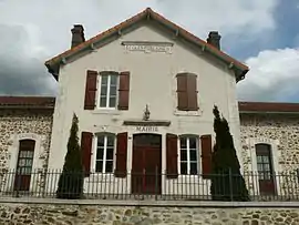 Town hall | |
Location of La Péruse 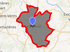
| |
 La Péruse  La Péruse | |
| Coordinates: 45°52′42″N 0°37′06″E | |
| Country | France |
| Region | Nouvelle-Aquitaine |
| Department | Charente |
| Arrondissement | Confolens |
| Canton | Charente-Vienne |
| Commune | Terres-de-Haute-Charente |
| Area 1 | 8.52 km2 (3.29 sq mi) |
| Population (2017)[1] | 511 |
| • Density | 60/km2 (160/sq mi) |
| Time zone | UTC+01:00 (CET) |
| • Summer (DST) | UTC+02:00 (CEST) |
| Postal code | 16270 |
| Elevation | 158–251 m (518–823 ft) (avg. 254 m or 833 ft) |
| 1 French Land Register data, which excludes lakes, ponds, glaciers > 1 km2 (0.386 sq mi or 247 acres) and river estuaries. | |
Population
| Year | Pop. | ±% |
|---|---|---|
| 1793 | 530 | — |
| 1800 | 501 | −5.5% |
| 1806 | 488 | −2.6% |
| 1821 | 554 | +13.5% |
| 1831 | 540 | −2.5% |
| 1841 | 601 | +11.3% |
| 1846 | 645 | +7.3% |
| 1851 | 673 | +4.3% |
| 1856 | 660 | −1.9% |
| 1861 | 611 | −7.4% |
| 1866 | 578 | −5.4% |
| 1872 | 557 | −3.6% |
| 1876 | 591 | +6.1% |
| 1881 | 624 | +5.6% |
| 1886 | 618 | −1.0% |
| 1891 | 605 | −2.1% |
| 1896 | 553 | −8.6% |
| 1901 | 548 | −0.9% |
| 1906 | 604 | +10.2% |
| 1911 | 643 | +6.5% |
| 1921 | 461 | −28.3% |
| 1926 | 466 | +1.1% |
| 1931 | 435 | −6.7% |
| 1936 | 436 | +0.2% |
| 1946 | 441 | +1.1% |
| 1954 | 427 | −3.2% |
| 1962 | 515 | +20.6% |
| 1968 | 465 | −9.7% |
| 1975 | 462 | −0.6% |
| 1982 | 562 | +21.6% |
| 1990 | 501 | −10.9% |
| 1999 | 514 | +2.6% |
| 2008 | 496 | −3.5% |
See also
References
- Téléchargement du fichier d'ensemble des populations légales en 2017, INSEE
- Arrêté préfectoral 28 September 2018, p. 19 (in French)
| Wikimedia Commons has media related to La Péruse. |
| Authority control |
|---|
This article is issued from Wikipedia. The text is licensed under Creative Commons - Attribution - Sharealike. Additional terms may apply for the media files.