La Paz, Indiana
Lapaz is a town in North Township, Marshall County, Indiana, United States. The population was 561 at the 2010 census.[3]
Lapaz, Indiana | |
|---|---|
| Town of Lapaz | |
 | |
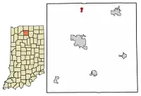 Location of Lapaz in Marshall County, Indiana. | |
| Coordinates: 41°27′28″N 86°18′32″W | |
| Country | United States |
| State | Indiana |
| County | Marshall |
| Township | North |
| Area | |
| • Total | 0.39 sq mi (1.00 km2) |
| • Land | 0.39 sq mi (1.00 km2) |
| • Water | 0.00 sq mi (0.00 km2) |
| Elevation | 863 ft (263 m) |
| Population | |
| • Total | 561 |
| • Estimate (2019)[4] | 549 |
| • Density | 1,414.95/sq mi (546.52/km2) |
| Time zone | UTC-5 (EST) |
| • Summer (DST) | UTC-4 (EST) |
| ZIP code | 46537 |
| Area code(s) | 574 |
| FIPS code | 18-42192[5] |
| GNIS feature ID | 437489 |
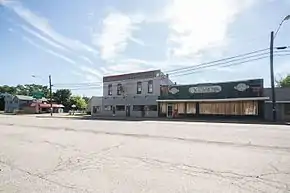
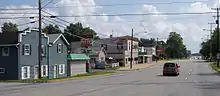
History
The town was founded in 1873[6] and was named for La Paz, Bolivia. At the time of its founding, it was served by the Chicago branch of the Baltimore and Ohio Railroad, now CSX. The B&O named a coach Lapaz in 1949 to honor the town.
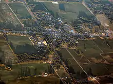
Geography
Lapaz is located at 41°27′28″N 86°18′32″W.[7] It is located on U.S. Route 31, just to the north of where it intersects with U.S. Route 6.
According to the 2010 census, La Paz has a total area of 0.38 square miles (0.98 km2), all land.[7]
Demographics
| Historical population | |||
|---|---|---|---|
| Census | Pop. | %± | |
| 1880 | 84 | — | |
| 1910 | 263 | — | |
| 1920 | 274 | 4.2% | |
| 1930 | 375 | 36.9% | |
| 1940 | 429 | 14.4% | |
| 1950 | 512 | 19.3% | |
| 1960 | 545 | 6.4% | |
| 1970 | 604 | 10.8% | |
| 1980 | 651 | 7.8% | |
| 1990 | 562 | −13.7% | |
| 2000 | 489 | −13.0% | |
| 2010 | 561 | 14.7% | |
| 2019 (est.) | 549 | [4] | −2.1% |
| U.S. Decennial Census[8] | |||
2010 census
As of the census[3] of 2010, there were 561 people, 216 households, and 144 families living in the town. The population density was 1,476.3 inhabitants per square mile (570.0/km2). There were 251 housing units at an average density of 660.5 per square mile (255.0/km2). The racial makeup of the town was 97.9% White, 0.2% African American, 0.2% Native American, 0.2% Asian, 0.5% from other races, and 1.1% from two or more races. Hispanic or Latino of any race were 4.3% of the population.
There were 216 households, of which 35.2% had children under the age of 18 living with them, 46.3% were married couples living together, 13.4% had a female householder with no husband present, 6.9% had a male householder with no wife present, and 33.3% were non-families. 28.2% of all households were made up of individuals, and 12.9% had someone living alone who was 65 years of age or older. The average household size was 2.60 and the average family size was 3.24.
The median age in the town was 35.1 years. 29.4% of residents were under the age of 18; 7.7% were between the ages of 18 and 24; 23.7% were from 25 to 44; 26.9% were from 45 to 64; and 12.3% were 65 years of age or older. The gender makeup of the town was 47.1% male and 52.9% female.
2000 census
As of the census[5] of 2000, there were 489 people, 209 households, and 136 families living in the town. The population density was 948.6 people per square mile (363.1/km2). There were 225 housing units at an average density of 436.5 per square mile (167.1/km2). The racial makeup of the town was 96.73% White, 0.20% African American, 0.82% Native American, 1.02% from other races, and 1.23% from two or more races. Hispanic or Latino of any race were 2.25% of the population.
There were 209 households, out of which 30.6% had children under the age of 18 living with them, 45.9% were married couples living together, 10.5% had a female householder with no husband present, and 34.9% were non-families. 30.6% of all households were made up of individuals, and 11.5% had someone living alone who was 65 years of age or older. The average household size was 2.34 and the average family size was 2.84.
In the town, the population was spread out, with 25.8% under the age of 18, 10.6% from 18 to 24, 31.7% from 25 to 44, 21.7% from 45 to 64, and 10.2% who were 65 years of age or older. The median age was 34 years. For every 100 females, there were 102.1 males. For every 100 females age 18 and over, there were 96.2 males.
The median income for a household in the town was $37,961, and the median income for a family was $39,667. Males had a median income of $30,089 versus $21,083 for females. The per capita income for the town was $16,658. About 4.1% of families and 5.2% of the population were below the poverty line, including 9.6% of those under age 18 and 4.2% of those age 65 or over.
Education
Public schools in La Paz are operated by Union-North United Schools.
ZIP code
La Paz has only one ZIP code: 46537
Notable people
- Gerald Archie Mangun, Pentecostal minister.
- Donald Yeagley, Indiana state legislator and labor
References
- "2019 U.S. Gazetteer Files". United States Census Bureau. Retrieved July 16, 2020.
- "US Board on Geographic Names". United States Geological Survey. 2007-10-25. Retrieved 2008-01-31.
- "La Paz town, Indiana". United States Census Bureau. Archived from the original on 2015-02-23. Retrieved 2015-02-23.
- "Population and Housing Unit Estimates". United States Census Bureau. May 24, 2020. Retrieved May 27, 2020.
- "U.S. Census website". United States Census Bureau. Retrieved 2008-01-31.
- McDonald, Daniel (1908). A Twentieth Century History of Marshall County, Indiana, Volume 1. Lewis Publishing Company. p. 134.
- "G001 - Geographic Identifiers - 2010 Census Summary File 1". United States Census Bureau. Archived from the original on 2020-02-13. Retrieved 2015-07-17.
- "Census of Population and Housing". Census.gov. Retrieved June 4, 2015.
Municipalities and communities of Marshall County, Indiana, United States | ||
|---|---|---|
| City | Map of Indiana highlighting Marshall County | |
| Towns | ||
| Townships | ||
| CDP | ||
| Unincorporated communities | ||
| Footnotes | ‡This populated place also has portions in an adjacent county or counties | |
| ||
