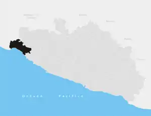
La Unión de Isidoro Montes de Oca
La Unión de Isidoro Montes de Oca is one of the 81 municipalities of Guerrero, in south-western Mexico. The municipal seat lies at La Unión. The municipality covers an area of 1,142 km².
La Unión de Isidoro Montes de Oca | |
|---|---|
 Beach at Petacalco, in the municipality of La Unión de Isidoro Montes de Oca | |
 Municipality of La Unión de Isidoro Montes de Oca in Guerrero | |
 La Unión de Isidoro Montes de Oca Location in Mexico | |
| Coordinates: 18°33′N 101°27′W | |
| Country | |
| State | Guerrero |
| Municipal seat | La Unión |
| Area | |
| • Total | 1,142 km2 (441 sq mi) |
| Population (2005) | |
| • Total | 25,230 |
As of 2005, the municipality had a total population of 25,230.[1]
The main towns are La Unión, population 3,079; Petacalco, population 2,671; Zacatula, population 1,417; Lagunillas, population 1,371; El Naranjito, population 1,167; and Surcua, population 1,046.[2]
History
On October 26, 1614, the Dutch Captain Joris van Spilbergen - involved in his country's war with Spain - raided with an expedition of five ships this part of the coast of the then Spanish Mexico. At Zacatula he captured the pearl fishing ship San Francisco.[3][4]
References
- "La Unión de Isidoro Montes de Oca". Enciclopedia de los Municipios de México. Instituto Nacional para el Federalismo y el Desarrollo Municipal. Archived from the original on June 1, 2007. Retrieved December 23, 2008.
- Instituto Nacional de Estadística y Geografía. Principales resultados por localidad 2005 (ITER). Retrieved on December 23, 2008
- Quanchi, Historical Dictionary of the Discovery and Exploration of the Pacific Islands, page 233
- Myers, Paul A., North to California, Llumina Press, 2004 ISBN 9781595262516
This article is issued from Wikipedia. The text is licensed under Creative Commons - Attribution - Sharealike. Additional terms may apply for the media files.
