Lac du Bourget
Lac du Bourget (French: [lak dy buʁʒɛ]; English: Lake Bourget), also locally known as Lac Gris ([lak gʁi]; English: Grey Lake) or Lac d'Aix ([lak d‿ɛ]), is a lake at the southernmost end of the Jura Mountains in the department of Savoie, France. It is the deepest lake located entirely within France, and either the largest or second largest after Lac de Grand-Lieu depending on season.
| Lac du Bourget | |
|---|---|
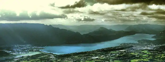
.JPG.webp) View from the heights of Viviers-du-Lac | |
 Lac du Bourget | |
| Location | Savoie, France |
| Coordinates | 45°44′N 5°52′E |
| Primary inflows | Leysse, Tillet, Sierroz |
| Primary outflows | Canal de Savières, Rhône |
| Catchment area | 560 km2 (220 sq mi) |
| Basin countries | France |
| Max. length | 18 km (11 mi) |
| Max. width | 3.5 km (2.2 mi) |
| Surface area | 44.5 km2 (17.2 sq mi) |
| Average depth | 85 m (279 ft) |
| Max. depth | 145 m (476 ft) |
| Water volume | 3,600×106 m3 (2,900,000 acre⋅ft) |
| Residence time | 8 years |
| Surface elevation | 231.5 m (760 ft) |
| Settlements | Aix-les-Bains Le Bourget-du-Lac Brison-Saint-Innocent Conjux |
| Official name | Lac du Bourget - Marais de Chautagne |
| Designated | 2 February 2003 |
| Reference no. | 1268[1] |
The largest town on its shore is Aix-les-Bains. Chambéry, the capital of Savoie, lies about 10 km south of the lake. The lake is mainly fed by the river Leysse (and other small rivers), and it drains towards the river Rhône through the Canal de Savières, an artificial channel. It is a Ramsar site. The extinct bezoule was found only in this lake.
The lake was formed during the last period of global glaciation in the Alps (Würm glaciation) during the Pleistocene epoch. It has a surface area of 44.5 square kilometres (4,450 hectares). The long and narrow north-south axis of the lake extends 18 km in length, and ranges between 1.6 km and 3.5 km in width.[2] The lake's average depth is 85 m, and its maximum depth in 145 m. The lake is meromictic, meaning that it has layers that do not mix.[3]
The lake is bordered by the steep summits of the Mont du Chat and the Chaîne de l'Épine on the west, and Bauges Mountains on the east, which form its shores.
Lac du Bourget was made famous by several romantic poems of Alphonse de Lamartine, including Le Lac,[4] as well as by descriptions by Xavier de Maistre, Honoré de Balzac, and Alexandre Dumas.
Origin of the name
Named Lacus de Burgeto in 1313, its name "Le Bourget" comes from the eponymous castle, which became the main residence of the Counts of Savoy from the middle of the 13th century until the following century. Formerly, it was called "Lac de Châtillon" (Ripa laci de Castellione in the 13th century), in reference to the castle and the eponymous seigneury. It is mentioned in particular in the donation made by the Count of Savoy Amédée III in 1125, for the foundation of the abbey of Hautecombe, "on the shore of the lake of Châtillon" (supra ripam loci de Castellione).
Climate
Lake Bourget features a continental-influenced oceanic climate (Köppen : Cfb). On the shores of the lake, during the winter, snow hardly accumulates on the ground. However, the surrounding mountains have a warm-summer humid continental climate (Köppen : Dfb), or a subalpine climate (Köppen : Dfc), with cold to very cold winters, and abundant snowfall.
References
- "Lac du Bourget - Marais de Chautagne". Ramsar Sites Information Service. Retrieved 25 April 2018.
- Agence Interactive. "Le lac du Bourget : activités, visites, nature, randonnées pédestres - Savoie Mont-Blanc (Savoie, Haute-Savoie, Alpes) - Savoie Mont Blanc (Savoie et Haute Savoie) - Alpes". Savoie-mont-blanc.com. Retrieved 29 October 2014.
- Jacquet, Stéphan; Briand, Jean-François; et al. (2003). "The proliferation of the toxic cyanobacterium Planktothrix rubescens following restoration of the largest natural French lake (Lac du Bourget)". Harmful Algae. 4 (4): 651–672. CiteSeerX 10.1.1.541.2297. doi:10.1016/j.hal.2003.12.006.
- "Poems Found in Translation, The Lake by Alphonse de Lamartine, translated by A.Z. Foreman". Poemstranslation.blogspot.com. Retrieved 29 October 2014.
External links
| Wikimedia Commons has media related to Lac du Bourget. |