Le Bourget-du-Lac
Le Bourget-du-Lac is a commune in the Savoie department in the Auvergne-Rhône-Alpes region in south-eastern France.
Le Bourget-du-Lac | |
|---|---|
.JPG.webp) | |
 Coat of arms | |
Location of Le Bourget-du-Lac 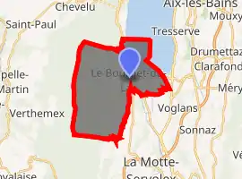
| |
 Le Bourget-du-Lac  Le Bourget-du-Lac | |
| Coordinates: 45°38′44″N 5°51′33″E | |
| Country | France |
| Region | Auvergne-Rhône-Alpes |
| Department | Savoie |
| Arrondissement | Chambéry |
| Canton | La Motte-Servolex |
| Intercommunality | CA Grand Lac |
| Government | |
| • Mayor (2014–2020) | Marie-Pierre François |
| Area 1 | 20.05 km2 (7.74 sq mi) |
| Population (2017-01-01)[1] | 4,866 |
| • Density | 240/km2 (630/sq mi) |
| Time zone | UTC+01:00 (CET) |
| • Summer (DST) | UTC+02:00 (CEST) |
| INSEE/Postal code | 73051 /73370 |
| Elevation | 226–1,496 m (741–4,908 ft) (avg. 241 m or 791 ft) |
| Website | www.lebourgetdulac.fr |
| 1 French Land Register data, which excludes lakes, ponds, glaciers > 1 km2 (0.386 sq mi or 247 acres) and river estuaries. | |
It lies near the Lac du Bourget and 12 km (7.5 mi) from Chambéry.

Climate
Le Bourget-du-Lac, just like Aix-les-Bains, features an oceanic climate (Köppen: Cfb), but with continental climate influences, due to its interior position within France and near several mountain ranges like Jura mountains, Bauges and Chartreuse mountains. Thus, winters are moderately cold with sporadic snowfall, while summers are pleasantly warm and sometimes, stormy. Convective rainfall is frequent for much of the year, rendering high precipitation/day quotas. In spite of this, Le Bourget-du-Lac is highly influenced by lake Bourget, which moderates temperatures.
| Climate data for Chambéry, Savoie, France (1981–2010 averages) | |||||||||||||
|---|---|---|---|---|---|---|---|---|---|---|---|---|---|
| Month | Jan | Feb | Mar | Apr | May | Jun | Jul | Aug | Sep | Oct | Nov | Dec | Year |
| Record high °C (°F) | 17.9 (64.2) |
20.5 (68.9) |
25.1 (77.2) |
29.5 (85.1) |
32.7 (90.9) |
36.1 (97.0) |
38.8 (101.8) |
38.8 (101.8) |
32.0 (89.6) |
29.0 (84.2) |
23.3 (73.9) |
22.7 (72.9) |
38.8 (101.8) |
| Average high °C (°F) | 5.8 (42.4) |
7.9 (46.2) |
12.6 (54.7) |
16.3 (61.3) |
20.8 (69.4) |
24.6 (76.3) |
27.4 (81.3) |
26.6 (79.9) |
22.0 (71.6) |
16.7 (62.1) |
10.1 (50.2) |
6.4 (43.5) |
16.4 (61.6) |
| Daily mean °C (°F) | 2.2 (36.0) |
3.6 (38.5) |
7.4 (45.3) |
10.7 (51.3) |
15.3 (59.5) |
18.7 (65.7) |
21.1 (70.0) |
20.4 (68.7) |
16.5 (61.7) |
12.1 (53.8) |
6.3 (43.3) |
3.1 (37.6) |
11.5 (52.6) |
| Average low °C (°F) | −1.4 (29.5) |
−0.7 (30.7) |
2.1 (35.8) |
5.1 (41.2) |
9.7 (49.5) |
12.8 (55.0) |
14.7 (58.5) |
14.2 (57.6) |
11.0 (51.8) |
7.4 (45.3) |
2.5 (36.5) |
−0.2 (31.6) |
6.4 (43.6) |
| Record low °C (°F) | −19.0 (−2.2) |
−14.4 (6.1) |
−10.3 (13.5) |
−4.6 (23.7) |
−1.4 (29.5) |
2.8 (37.0) |
5.4 (41.7) |
5.0 (41.0) |
1.0 (33.8) |
−4.3 (24.3) |
−10.8 (12.6) |
−13.5 (7.7) |
−19.0 (−2.2) |
| Average precipitation mm (inches) | 102.6 (4.04) |
91.5 (3.60) |
100.0 (3.94) |
92.2 (3.63) |
104.2 (4.10) |
94.8 (3.73) |
86.6 (3.41) |
91.7 (3.61) |
111.8 (4.40) |
122.6 (4.83) |
105.0 (4.13) |
118.0 (4.65) |
1,221 (48.07) |
| Average precipitation days | 9.9 | 8.0 | 9.7 | 9.9 | 11.4 | 9.7 | 7.7 | 8.9 | 8.6 | 10.3 | 9.7 | 10.0 | 113.8 |
| Average snowy days | 5.4 | 4.6 | 2.2 | 1.2 | 0.0 | 0.0 | 0.0 | 0.0 | 0.0 | 0.0 | 1.7 | 3.2 | 18.3 |
| Mean monthly sunshine hours | 77.7 | 104.4 | 156.7 | 172.8 | 202.5 | 234.0 | 260.1 | 232.5 | 176.3 | 121.4 | 71.2 | 60.6 | 1,870.2 |
| Source: Météo France[2][3] | |||||||||||||
See also
References
- "Populations légales 2017". INSEE. Retrieved 6 January 2020.
- "Données climatiques de la station de Chambéry" (in French). Meteo France. Retrieved 26 December 2015.
- "Climat Rhône-Alpes" (in French). Meteo France. Retrieved 26 December 2015.
External links
| Wikimedia Commons has media related to Le Bourget-du-Lac. |
| Authority control |
|---|