Ladismith
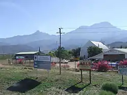
Ladismith is a town and agricultural centre in the western Klein Karoo region of South Africa's Western Cape province.
Ladismith | |
|---|---|
 Ladismith | |
 Ladismith  Ladismith | |
| Coordinates: 33°29′S 21°16′E | |
| Country | South Africa |
| Province | Western Cape |
| District | Garden Route |
| Municipality | Kannaland |
| Area | |
| • Total | 25.8 km2 (10.0 sq mi) |
| Elevation | 540 m (1,770 ft) |
| Population (2011)[1] | |
| • Total | 7,127 |
| • Density | 280/km2 (720/sq mi) |
| Racial makeup (2011) | |
| • Black African | 6.4% |
| • Coloured | 81.3% |
| • Indian/Asian | 0.3% |
| • White | 11.5% |
| • Other | 0.5% |
| First languages (2011) | |
| • Afrikaans | 95.7% |
| • English | 1.9% |
| • Other | 2.4% |
| Time zone | UTC+2 (SAST) |
| Postal code (street) | 6655 |
| PO box | 6655 |
| Area code | 028 |
Geography
It is situated adjacent to a series of fertile, irrigated valleys, at an elevation of 550 m above sea level, at the southern base of the Swartberg. It is currently included in the southern Kannaland Local Municipality. The nearest towns are Calitzdorp to the east, Vanwyksdorp and Riversdale to the south and Laingsburg to the north.
History
In 1852 the farm Elandsvlei was set aside for the town, and it became a municipality in 1862. It was named after Lady Juana María Smith, the wife of Sir Harry Smith, one of two towns in South Africa named after her, the other being Ladysmith in KwaZulu-Natal.[2]
Notes
- Sum of the Main Places Ladismith and Nissenville from Census 2011.
- Raper, P.E. (2004). South African Place Names. Jonathan Ball, Jhb & Cape Town. p. 199. ISBN 1-86842-190-2.
External links
- Ladismith, official page
 Media related to Ladismith at Wikimedia Commons
Municipalities and communities of Garden Route District Municipality, Western Cape | ||
|---|---|---|
District seat: George | ||
| Bitou | .svg.png.webp) Garden Route District within South Africa | |
| George | ||
| Hessequa | ||
| Kannaland | ||
| Knysna | ||
| Mossel Bay | ||
| Oudtshoorn | ||
This article is issued from Wikipedia. The text is licensed under Creative Commons - Attribution - Sharealike. Additional terms may apply for the media files.