Laguépie
Laguépie is a commune in the Tarn-et-Garonne department in the Occitanie region in southern France.
Laguépie | |
|---|---|
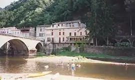 The River Viaur in Laguépie, in 1995 | |
.svg.png.webp) Coat of arms | |
Location of Laguépie 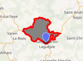
| |
 Laguépie  Laguépie | |
| Coordinates: 44°08′43″N 1°58′14″E | |
| Country | France |
| Region | Occitanie |
| Department | Tarn-et-Garonne |
| Arrondissement | Montauban |
| Canton | Quercy-Rouergue |
| Intercommunality | Quercy Rouergue et des Gorges de l'Aveyron |
| Government | |
| • Mayor (2001–2008) | Jacques Alaux |
| Area 1 | 14.86 km2 (5.74 sq mi) |
| Population (2017-01-01)[1] | 608 |
| • Density | 41/km2 (110/sq mi) |
| Time zone | UTC+01:00 (CET) |
| • Summer (DST) | UTC+02:00 (CEST) |
| INSEE/Postal code | 82088 /82250 |
| Elevation | 140–387 m (459–1,270 ft) (avg. 157 m or 515 ft) |
| 1 French Land Register data, which excludes lakes, ponds, glaciers > 1 km2 (0.386 sq mi or 247 acres) and river estuaries. | |
Situated in the Midi Quercy at the confluence of the rivers Aveyron and Viaur and at the corner of 3 different departments, Laguepie is a typical village of La France Profonde. It is in reality two villages. Laguepie itself (pop 733) is now in the Tarn-et-Garonne and forms an island in the middle of the two rivers. Until 1808 when Napoleon I created the Tarn-et-Garonne it belonged to the Aveyron, forming part of the diocese of Rodez. Its sister village St Martin Laguepie (pop 530) lines the left bank of the Viaur is dominated by the ruins of the medieval chateau and is in the department of the Tarn.
References
- "Populations légales 2017". INSEE. Retrieved 6 January 2020.
| Wikimedia Commons has media related to Laguépie. |
This article is issued from Wikipedia. The text is licensed under Creative Commons - Attribution - Sharealike. Additional terms may apply for the media files.