Laid, Sutherland
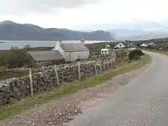
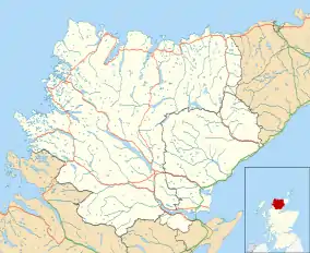
Laid is a remote, linear crofting township scattered along the A838 road on the western shore of the sea loch, Loch Eriboll in Sutherland in the northern Scottish Highlands.[1][2] The township is close to the north coast of Scotland in the Scottish council area of Highland around 6 miles (10 km) south of the village of Durness. The township of Portnancon is located 1 mile (1.6 km) northeast of Laid, along the A838 road.
Laid
| |
|---|---|
 Laid along the A838 and Loch Eriboll | |
 Laid Location within the Sutherland area | |
| OS grid reference | NC411591 |
| Council area | |
| Country | Scotland |
| Sovereign state | United Kingdom |
| Post town | Lairg |
| Postcode district | IV27 4 |
| Dialling code | 01971 |
The township was first settled in 1832, being created to house residents of Eriboll who had been cleared from the eastern shore of Loch Erriboll.[3] The population has always been low with a small number of crofts on the land.[1] The primary school closed in 1955.[3]
The area was considered as a site for a proposed "superquarry" during the 1990s. The plan would have meant a Liechtenstein company, Vibel SA, develop the area for quarrying for aggregate use. The plans were dropped and Highland Council excluded the possibility of a major quarry in the area in its late 1990s structure plan,[1] although plans for some mineral development continued.[4][5]
References
- Setback for Laid crofters' grazing plan, The Guardian, 1999-10-24. Retrieved 2015-09-29.
- Gittings B, Munro D Laid, The Gazetteer for Scotland, School of GeoSciences, University of Edinburgh and The Royal Scottish Geographical Society. Retrieved 2019-03-09.
- Loch Eriboll, Undiscovered Scotland. Retrieved 2015-09-29.
- Highland estate to change hands, Herald Scotland, 2000-03-27. Retrieved 2015-09-29.
- Crofters want mineral rights loophole closed, Herald Scotland, 2003-01-03. Retrieved 2015-09-29.
| Wikimedia Commons has media related to Laid, Sutherland. |