Lamine Township, Cooper County, Missouri
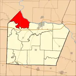
in Cooper County, in the U.S. state of Missouri. Twenty-two of Missouri's 114 counties, including Cooper County, have civil township governments. The other 92 counties have townships which are geographical but not governmental (civil). According to the 1860 Census, the population of Lamine Township was 830 (524 whites, 306 slaves). As of the 2010 Census, Lamine Township's population was 268, a decrease from the 2000 Census population of 289.[1]
Lamine Township | |
|---|---|
 Location in Cooper County | |
| Coordinates: 38°59′19″N 92°56′32″W | |
| Country | |
| State | |
| County | Cooper |
| Area | |
| • Total | 40.86 sq mi (105.83 km2) |
| • Land | 39.5 sq mi (102.31 km2) |
| • Water | 1.36 sq mi (3.52 km2) 3.33% |
| Elevation | 755 ft (230 m) |
| Population (2010) | |
| • Total | 268 |
| • Density | 6.8/sq mi (2.6/km2) |
| Time zone | UTC-6 (CST) |
| • Summer (DST) | UTC-5 (CDT) |
| ZIP code | 65322 |
| GNIS feature ID | 0766531 |
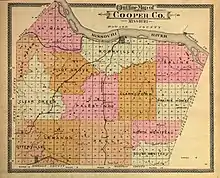
Lamine Township is one of 14 civil townships

The township takes its name from the Lamine River.[2]
The only town in the Lamine Township is the unincorporated community of Lamine.
Geography
According to the United States Census Bureau, Lamine Township covers an area of 40.86 square miles (105.83 square kilometers); of this, 39.5 square miles (102.31 square kilometers, 96.67 percent) is land and 1.36 square miles (3.52 square kilometers, 3.33 percent) is water.
History
On June 8, 1804 the Lewis and Clark Expedition traveling on the Missouri River arrived at the mouth of the LaMine River in what would come to be known as the Lamine Township.[3] LaMine was settled in 1811 by Revolutionary War veteran David Jones (1761-1838), his son-in-law Stephen Turley (1786-1851), Jesse B. Turley (1801-1861), Samuel Turley (1790-1870), Thomas McMahan (1786-1859), James McMahan (1789-1857), son-in-law William Reid (1774-1854), and Saunders Townsend[4][5] In 1812 or 1813 there was a Fort McMahan in the Lamine Township, exact location unknown.[6] On March 2, 1819 Stephen Turley was granted a license to operate a ferry across the Lamine River.[7][8] On March 2, 1819 John Potter was appointed constable of Lamine Township by the Cooper County Court.[9] On April 9, 1821 Bryant T. Nolan was appointed constable of the Lamine Township by the Cooper County Court.[10] The first will probated by Cooper County was that of Thomas McMahan, a resident of the Lamine Township in 1821.[11]
Turley Bridge over the Lamine River in Lamine was built in 1906 and replaced in 1937 [ 38.940571°N 92.872110°W ]. One span of the bridge was sold to Boone County, Missouri and is on Moon Valley Road Hinkson Creek Trail [ 38.946242°N 92.306854°W ]. The other span now crosses the Petite Saline Creek near Gooch's Mill.

Hopewell Indian Settlements
There are two known Hopewell Indian Settlements in the Lamine township: the Mellor settlement and the Imhoff settlement (100-300 A.D.). The Mellor settlement is at the confluence of the Lamine River with the Missouri River on the property known as "Cape Verde" [ 38.983083°N 92.863532°W ] owned in the early 1900s by Thomas Edward Mellor and then by his son John Paul Mellor. "At least 20 large earthen burial mounds overlook the Mellor settlement from the north-facing Missouri River escarpment."[12] The Imhoff settlement is about one-half mile downstream from the confluence of the Blackwater River with the Lamine River. These two settlements were excavated in the 1970s by archaeologist Marvin Kay and the findings were published in the Missouri Archaeological Society Research Series in 1980.[13]
Unincorporated towns
Adjacent townships
- Boonslick Township, Howard County (northeast)
- Boonville Township, Cooper County (east)
- Pilot Grove Township, Cooper County (south)
- Blackwater Township, Cooper County (southwest)
- Blackwater Township, Saline County (west)
- Arrow Rock Township, Saline County (northwest)
Cemeteries
The township contains at least the following cemeteries:
- William Henry Ashley Burial Site (where the Lamine and Missouri rivers meet)
- Herndon Family Cemetery
- Higgerson Family Cemetery
- Hoke Family Cemetery
- Old Lamine Cemetery at 38.968330°N 92.9275000°W
- Samuel McMahan Family Cemetery
- Thomas McMahan, Jr. Family Cemetery
- Thomas McMahan, Sr. Family Cemetery
- Schuster Family Cemetery
- Turley Family Cemetery at 38.951815°N 92.875816°W
Major highways
Lakes
- Widel Lake at 38.953286°N 92.923649°W
Landmarks
School districts
- Blackwater R-2
Political districts
- Missouri's 6th congressional district
- State House District 117
- State Senate District 21
References
- United States Census Bureau 2008 TIGER/Line Shapefiles
- United States Board on Geographic Names (GNIS)
- United States National Atlas
- "U.S. Census website". Retrieved 2009-05-13.
- "Cooper County Place Names, 1928–1945 (archived)". The State Historical Society of Missouri. Archived from the original on 24 June 2016. Retrieved 24 September 2016.CS1 maint: bot: original URL status unknown (link)
- Levens, Henry C.; Drake, Nathaniel M. (1876). A History of Cooper County, Missouri. St. Louis, Missouri: Perrin & Smith. p. 13.
- Johnson, William Foreman (1919). History of Cooper County, Missouri. Topeka: Historical Publishing Co. p. 231.
- Mitchell, Beth; Miller, Amelia F.; Turley Hetzler, Ruth Jean; Lindgren, Patricia Kelley; Carlisle, Denzil; Buck, Camellus Wilson; Smith, Mary Edna Mansfield; Smith, Gladys Harden; Isbell, Ray; Turley, Lester F. (1981). Turley Family Records (PDF). Alexandria, VA: Turley Family Historical Research Assoc. pp. 76–77.
- Levens, Henry C.; Drake, Nathaniel M. (1876). A History of Cooper County, Missouri. St. Louis, Missouri: Perrin & Smith. p. 154.
- Illustrated Atlas Map of Cooper County, Missouri. St. Louis, MO: St. Louis Atlas Publishing Co. 1877. p. 11. Retrieved 5 February 2019.
- Levens, Henry C.; Drake, Nathaniel M. (1876). A History of Cooper County, Missouri. St. Louis, Missouri: Perrin & Smith. p. 51.
- Levens, Henry C.; Drake, Nathaniel M. (1876). A History of Cooper County, Missouri. St. Louis, Missouri: Perrin & Smith. p. 50.
- Levens, Henry C.; Drake, Nathaniel M. (1876). A History of Cooper County, Missouri. St. Louis, Missouri: Perrin & Smith. p. 57.
- Levens, Henry C.; Drake, Nathaniel M. (1876). A History of Cooper County, Missouri. St. Louis, Missouri: Perrin & Smith. p. 57.
- Kay, Marvin (1980). "The Central Missouri Hopewell Subsistence Settlement System". Missouri Archaeological Society Research Series (15): 13–17.
- Kay, Marvin (1980). "The Central Missouri Hopewell Subsistence Settlement System". Missouri Archaeological Society Research Series (15): iii-58.
