Lan Sak District
Lan Sak (Thai: ลานสัก, pronounced [lāːn sàk]) is a district (amphoe) in northern Uthai Thani Province, northern Thailand.
Lan Sak
ลานสัก | |
|---|---|
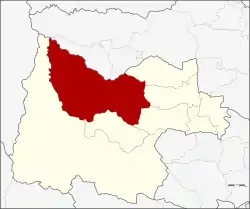 District location in Uthai Thani Province | |
| Coordinates: 15°27′10″N 99°34′34″E | |
| Country | Thailand |
| Province | Uthai Thani |
| Seat | Lan Sak |
| Area | |
| • Total | 1,080.4 km2 (417.1 sq mi) |
| Population (2005) | |
| • Total | 57,548 |
| • Density | 53.3/km2 (138/sq mi) |
| Time zone | UTC+7 (ICT) |
| Postal code | 61160 |
| Geocode | 6107 |
History
Tambons Lan Sak and Pradu Yuen of Ban Rai District were combined as a minor district (king amphoe) on 15 October 1975.[1] The minor district office was in Ban Pak Muean. It was upgraded to a full district on 13 July 1981.[2] At the same time, the office was moved to Ban Kao.
Geography
Neighboring districts are (from the east clockwise) Sawang Arom, Thap Than, Nong Chang, Huai Khot, and Ban Rai of Uthai Thani Province; Mae Poen and Chum Ta Bong of Nakhon Sawan Province.
The important water resources are the Huai Thap Salao reservoir and Kha Khaeng River (Huai Kha Khaeng).
Administration
The district is divided into six sub-districts (tambons), which are further subdivided into 81 villages (mubans). The township (thesaban tambon) Lan Sak covers parts of tambons Lan Sak and Pradu Yuen. There are a further six tambon administrative organizations (TAO).
| No. | Name | Thai name | Villages | Pop. | |
|---|---|---|---|---|---|
| 1. | Lan Sak | ลานสัก | 10 | 13,905 | |
| 2. | Pradu Yuen | ประดู่ยืน | 12 | 6,697 | |
| 3. | Pa O | ป่าอ้อ | 10 | 7,358 | |
| 4. | Rabam | ระบำ | 19 | 12,573 | |
| 5. | Nam Rop | น้ำรอบ | 18 | 9,635 | |
| 6. | Thung Na Ngam | ทุ่งนางาม | 12 | 7,380 |
Nature
Hup Pa Tat is a broad valley located in the north of Uthai Thani Province.
References
- ประกาศกระทรวงมหาดไทย เรื่อง แบ่งท้องที่อำเภอบ้านไร่ จังหวัดอุทัยธานี ตั้งเป็นกิ่งอำเภอลานสัก (PDF). Royal Gazette (in Thai). 92 (213 ง): 2624. 14 October 1975.
- พระราชกฤษฎีกาตั้งอำเภอหนองใหญ่ อำเภอบ่อไร่ อำเภอพรหมคีรี อำเภอนาบอน อำเภอบางสะพานน้อย อำเภอนาดี อำเภอกงหรา อำเภอวังทรายพูน อำเภอธารโต อำเภอคำตากล้า อำเภอศรีนคร อำเภอด่านช้าง อำเภอพรเจริญ อำเภอวังสามหมอ และอำเภอลานสัก พ.ศ. ๒๕๒๔ (PDF). Royal Gazette (in Thai). 98 (115 ก Special): 7–10. 13 July 1981.