Larche, Alpes-de-Haute-Provence
Larche is a former commune in the Alpes-de-Haute-Provence department in southeastern France. On 1 January 2016, it was merged into the new commune Val-d'Oronaye.[2]
Larche | |
|---|---|
Part of Val-d'Oronaye | |
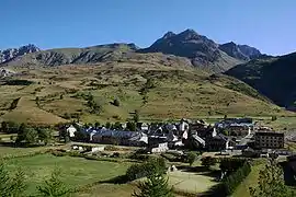 A general view of the village of Larche | |
Location of Larche 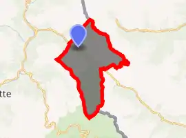
| |
 Larche  Larche | |
| Coordinates: 44°27′08″N 6°50′50″E | |
| Country | France |
| Region | Provence-Alpes-Côte d'Azur |
| Department | Alpes-de-Haute-Provence |
| Arrondissement | Barcelonnette |
| Canton | Barcelonnette |
| Commune | Val-d'Oronaye |
| Area 1 | 68.86 km2 (26.59 sq mi) |
| Population (2017)[1] | 58 |
| • Density | 0.84/km2 (2.2/sq mi) |
| Time zone | UTC+01:00 (CET) |
| • Summer (DST) | UTC+02:00 (CEST) |
| Postal code | 04530 |
| Elevation | 1,606–3,165 m (5,269–10,384 ft) (avg. 1,697 m or 5,568 ft) |
| 1 French Land Register data, which excludes lakes, ponds, glaciers > 1 km2 (0.386 sq mi or 247 acres) and river estuaries. | |
Geography
It lies on the northwestern foot of the Maddalena Pass, called Col de Larche in French.
Population
| Year | Pop. | ±% |
|---|---|---|
| 1765 | 876 | — |
| 1793 | 679 | −22.5% |
| 1800 | 848 | +24.9% |
| 1806 | 747 | −11.9% |
| 1821 | 784 | +5.0% |
| 1831 | 789 | +0.6% |
| 1836 | 788 | −0.1% |
| 1841 | 738 | −6.3% |
| 1846 | 677 | −8.3% |
| 1851 | 700 | +3.4% |
| 1856 | 672 | −4.0% |
| 1861 | 677 | +0.7% |
| 1866 | 650 | −4.0% |
| 1872 | 665 | +2.3% |
| 1876 | 645 | −3.0% |
| 1881 | 615 | −4.7% |
| 1886 | 787 | +28.0% |
| 1891 | 552 | −29.9% |
| 1896 | 576 | +4.3% |
| 1901 | 558 | −3.1% |
| 1906 | 587 | +5.2% |
| 1911 | 552 | −6.0% |
| 1921 | 377 | −31.7% |
| 1926 | 362 | −4.0% |
| 1931 | 299 | −17.4% |
| 1936 | 267 | −10.7% |
| 1954 | 151 | −43.4% |
| 1962 | 102 | −32.5% |
| 1968 | 128 | +25.5% |
| 1975 | 100 | −21.9% |
| 1982 | 91 | −9.0% |
| 1990 | 71 | −22.0% |
| 1999 | 83 | +16.9% |
| 2008 | 72 | −13.3% |
References
- Téléchargement du fichier d'ensemble des populations légales en 2017, INSEE
- Arrêté préfectoral 14 December 2015 (in French)
| Wikimedia Commons has media related to Larche, Alpes-de-Haute-Provence. |
| Authority control |
|---|
This article is issued from Wikipedia. The text is licensed under Creative Commons - Attribution - Sharealike. Additional terms may apply for the media files.
