Lavkushnagar
Lavkushnagar, formerly known as Laundi, is a town/city/tehshil and a nagar panchayat in Chhatarpur district in the Indian state of Madhya Pradesh. It is about 55 km away from Chhatarpur and 37 km from the temple town Khajuraho. The Urmil and Kail Rivers flow through this town. The Civil Airport Khajuraho and Dumra, Harpalpur, and Khajuraho Railway Station are located nearby, and links it to some major towns and cities of Madhya Pradesh. It also has a Civil Court, a Sub Jail, and a Police Station.
Lavkushnagar
Laundi | |
|---|---|
City | |
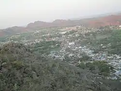 View from the top of Mata Bambar Baini Mountain | |
 Lavkushnagar Location in Madhya Pradesh, India  Lavkushnagar Lavkushnagar (India) | |
| Coordinates: 25°0′30″N 80°20′31″E | |
| Country | |
| State | Madhya Pradesh |
| District | Chhatarpur |
| Population (2011) | |
| • Total | 22,075 |
| Languages | |
| • Official | Hindi |
| Time zone | UTC+5:30 (IST) |
| PIN | 471515 |

Demographics
As of 2001 India census,[1] Laundi had a population of 20,186. Males constitute 54% of the population and females 46%. Laundi has an average literacy rate of 61%, higher than the national average of 59.5%: male literacy is 69%, and female literacy is 52%. In Laundi, 16% of the population is under 6 years of ago.
Geography
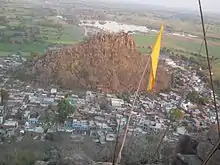
Lavkushnagar, is surrounded by many mountains. The tallest mountain is Mata Bambar Baini Temple mountain. To reach the top of the mountain there are approximately 350–380 stairs.
Places to visit
- The temple of Mata Bambar Baini is located on a hill in Lavkushnagar.
- Mata Anjini Mandir (Temple) behind boys higher secondary school
- Santoshi mata temple near bus stand
- Durga mata temple near new bus stand
- Gaytri mandir (Temple) second largest and well maintained gaytri mandir of chhatarpur disst.
- Major tourist attractions in the vicinity include Ken Gharial Sanctuary, Pandava Waterfall, and Shilpgram, which are easily accessible from Lavkushnagar.
- Famous Temple Of Jhinnan Hanuman Ji is Location Mahoba Road Lavkush Nagar
- Pankaj park is location chandla road Lavkush Nagar
- Disha Net Point is Location Chandla Road Lavkush Nagaar ( High speed internet connectivity and CSC services )
- Swami vivekanand Park is location bus stand ( Mid point of LK City )
Transport
References
| Wikimedia Commons has media related to Lavkushnagar. |
- "Census of India 2001: Data from the 2001 Census, including cities, villages and towns (Provisional)". Census Commission of India. Archived from the original on 16 June 2004. Retrieved 1 November 2008.