Lebo, Kansas
Lebo is a city in Coffey County, Kansas, United States. As of the 2010 census, the city population was 940.[6]
Lebo, Kansas | |
|---|---|
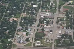 Aerial view of Lebo (2014) | |
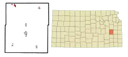 Location within Coffey County and Kansas | |
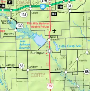 KDOT map of Coffey County (legend) | |
| Coordinates: 38°24′56″N 95°51′31″W | |
| Country | United States |
| State | Kansas |
| County | Coffey |
| Area | |
| • Total | 1.04 sq mi (2.71 km2) |
| • Land | 0.96 sq mi (2.48 km2) |
| • Water | 0.09 sq mi (0.23 km2) |
| Elevation | 1,171 ft (357 m) |
| Population | |
| • Total | 940 |
| • Estimate (2019)[3] | 887 |
| • Density | 926.85/sq mi (357.69/km2) |
| Time zone | UTC-6 (Central (CST)) |
| • Summer (DST) | UTC-5 (CDT) |
| ZIP code | 66856 |
| Area code | 620 |
| FIPS code | 20-39125 [4] |
| GNIS feature ID | 0477548 [5] |
| Website | leboks.org |
History
Lebo was founded in 1883.[7] It was named for Capt. Joe Lebo, a pioneer settler.[8]
The first post office in Lebo was established on June 4, 1883.[9]
Geography
Lebo is located at 38°24′56″N 95°51′31″W (38.415517, -95.858633).[10] According to the United States Census Bureau, the city has a total area of 1.05 square miles (2.72 km2), of which 0.96 square miles (2.49 km2) is land and 0.09 square miles (0.23 km2) is water.[11]
Climate
The climate in this area is characterized by hot, humid summers and generally mild to cool winters. According to the Köppen Climate Classification system, Lebo has a humid subtropical climate, abbreviated "Cfa" on climate maps.[12]
Area attractions
Attractions of interest to travelers include Lebo Lake, John Redmond Reservoir, Melvern Reservoir, Coffey County Lake, Beto Junction, historic Arvonia town and the Coffey County Museum.
Demographics
| Historical population | |||
|---|---|---|---|
| Census | Pop. | %± | |
| 1890 | 538 | — | |
| 1900 | 605 | 12.5% | |
| 1910 | 560 | −7.4% | |
| 1920 | 572 | 2.1% | |
| 1930 | 590 | 3.1% | |
| 1940 | 522 | −11.5% | |
| 1950 | 575 | 10.2% | |
| 1960 | 498 | −13.4% | |
| 1970 | 589 | 18.3% | |
| 1980 | 966 | 64.0% | |
| 1990 | 835 | −13.6% | |
| 2000 | 961 | 15.1% | |
| 2010 | 940 | −2.2% | |
| 2019 (est.) | 887 | [3] | −5.6% |
| U.S. Decennial Census | |||
2010 census
As of the census[2] of 2010, there were 940 people, 371 households, and 272 families living in the city. The population density was 979.2 inhabitants per square mile (378.1/km2). There were 411 housing units at an average density of 428.1 per square mile (165.3/km2). The racial makeup of the city was 98.9% White, 0.3% African American, 0.2% Native American, 0.1% from other races, and 0.4% from two or more races. Hispanic or Latino of any race were 1.4% of the population.
There were 371 households, of which 35.3% had children under the age of 18 living with them, 59.0% were married couples living together, 9.4% had a female householder with no husband present, 4.9% had a male householder with no wife present, and 26.7% were non-families. 22.4% of all households were made up of individuals, and 9.1% had someone living alone who was 65 years of age or older. The average household size was 2.53 and the average family size was 2.94.
The median age in the city was 40.4 years. 26.1% of residents were under the age of 18; 8.2% were between the ages of 18 and 24; 22.9% were from 25 to 44; 26% were from 45 to 64; and 16.8% were 65 years of age or older. The gender makeup of the city was 52.1% male and 47.9% female.
2000 census
As of the census[4] of 2000, there were 961 people, 371 households, and 271 families living in the city. The population density was 969.2 people per square mile (374.8/km2). There were 387 housing units at an average density of 390.3 per square mile (150.9/km2). The racial makeup of the city was 96.88% White, 0.42% Native American, 1.56% from other races, and 1.14% from two or more races. Hispanic or Latino of any race were 2.81% of the population.
There were 371 households, out of which 35.8% had children under the age of 18 living with them, 60.6% were married couples living together, 7.8% had a female householder with no husband present, and 26.7% were non-families. 23.2% of all households were made up of individuals, and 12.1% had someone living alone who was 65 years of age or older. The average household size was 2.59 and the average family size was 3.04.
In the city, the population was spread out, with 28.6% under the age of 18, 6.6% from 18 to 24, 27.2% from 25 to 44, 22.7% from 45 to 64, and 15.0% who were 65 years of age or older. The median age was 36 years. For every 100 females, there were 99.8 males. For every 100 females age 18 and over, there were 90.0 males.
The median income for a household in the city was $39,297, and the median income for a family was $45,089. Males had a median income of $31,058 versus $19,821 for females. The per capita income for the city was $16,532. About 4.6% of families and 5.2% of the population were below the poverty line, including 1.8% of those under age 18 and 10.7% of those age 65 or over.
Education
The community is served by Lebo–Waverly USD 243 public school district, and has two schools in the city: Lebo High School and Lebo Grade School.
See also
References
- "2019 U.S. Gazetteer Files". United States Census Bureau. Retrieved July 24, 2020.
- "U.S. Census website". United States Census Bureau. Retrieved 2012-07-06.
- "Population and Housing Unit Estimates". United States Census Bureau. May 24, 2020. Retrieved May 27, 2020.
- "U.S. Census website". United States Census Bureau. Retrieved 2008-01-31.
- "US Board on Geographic Names". United States Geological Survey. 2007-10-25. Retrieved 2008-01-31.
- "2010 City Population and Housing Occupancy Status". U.S. Census Bureau. Retrieved February 3, 2012.
- Kansas State Historical Society (1916). Biennial Report of the Board of Directors of the Kansas State Historical Society. Kansas State Printing Plant. p. 165.
- Heim, Michael (2007). Exploring Kansas Highways. p. 9. ISBN 9780974435886.
- "Kansas Post Offices, 1828-1961 (archived)". Kansas Historical Society. Archived from the original on 9 October 2013. Retrieved 6 June 2014.
- "US Gazetteer files: 2010, 2000, and 1990". United States Census Bureau. 2011-02-12. Retrieved 2011-04-23.
- "US Gazetteer files 2010". United States Census Bureau. Archived from the original on 2012-01-24. Retrieved 2012-07-06.
- Climate Summary for Lebo, Kansas
External links
Municipalities and communities of Coffey County, Kansas, United States | ||
|---|---|---|
| Cities |  Map of Kansas highlighting Coffey County | |
| Unincorporated communities |
| |
| Townships | ||
| ||