Leica Geosystems
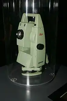
Leica Geosystems (formerly known as Wild Heerbrugg or just Wild) based in eastern Switzerland produces products and systems for surveying and geographical measurement (geomatics). Its products employ a variety of technologies including GPS satellite navigation and laser rangefinders to enable users to model existing structures, terrains in computer based systems to high accuracies, often under 1 cm.
 | |
| Type | part of the Hexagon AB |
|---|---|
| Industry | Surveying & Engineering Geographic Information Systems (GIS) High Precision Measurement instruments |
| Founded | Heerbrugg, Switzerland (1921) |
| Headquarters | Heerbrugg, Canton St. Gallen, Switzerland |
Number of employees | > 3,500[1] |
| Website | www.leica-geosystems.com |

History
The brand Leica, better known for its cameras, was formed on 2 April 1990 after the merger of several companies. In 2005, the company was acquired by Hexagon AB. Leica was listed on the Swiss stock exchange until the 7 August 2006 which saw the cancellation of all publicly held registered shares in Leica Geosystems Holdings Ltd and delisting of all listed registered shares of a par value of CHF 50.[2]
Leica Geosystems Geospatial Imaging is a Strategic Member in the Open Geospatial Consortium since 2008. Strategic Membership is the highest level of membership in the OGC. Strategic Members provide significant resources to support OGC objectives in the form of funding for program initiatives and staff resources inserted into the OGC process.[3]
Heinrich Wild (1877–1951) of Glarus, Switzerland, a leading designer of geodetic and astronomical instruments, began his career as an apprentice surveyor. In 1908, having invented a military rangefinder and convinced Zeiss to manufacture it, Wild moved to the city of Jena and became head of the new Zeiss branch responsible for surveying instruments, GEO.
Wild returned to Switzerland after the First World War.[4] In April 1921, with Colonel Jacob Schmidheiny of Balgach and geologist Dr. Robert Helbling of Flums and with the help of Swiss financiers, he founded the Heinrich Wild, Werkstätte für Feinmechanik und Optik in Heerbrugg in the Alpine Rhine Valley. In the early 1930s, having recognized that he was not cut out to be a factory manager, Wild moved to Zurich, severed his connections with the firm in Heerbrugg, and designed instruments for Kern & Co in Aarau. His old firm became Wild Heerbrugg in 1937.
It merged with the optical firm of Ernst Leitz of Wetzlar in 1987, acquired a majority interest in Kern in 1988, was renamed Wild Leitz AG in 1989, and became part of the Leica holding company in 1990. Starting in 1996, the company was divided gradually into smaller units. Thus in 1996, Leica Camera AG was founded, followed in October 1997 by Leica Geosystems AG, and on April 1, 1998 by Leica Microsystems AG.
Today these three companies are all independent public companies. Leica Geosystems produces - in continuation of Wild Heerbrugg - the geodetic instruments and is the global market leader in this section. The main customers of Leica Geosystems are surveyors, manufacturers and GIS companies.
In 2000 Leica Geosystems purchased Cyra Technologies, maker of the Cyrax laser 3D scanner line. In April 2001, Leica Geosystems acquired ERDAS, Inc., a remote sensing software firm, and LH Systems, a photogrammetric software firm (see IMAGINE Photogrammetry). These two companies were merged into software company, ERDAS, Inc.[5] ERDAS purchased Acquis, ER Mapper and IONIC in 2007.[6][7] This expanded further ERDAS in the remote sensing market, let them enter the enterprise topological GIS market, and expanded their footprint in the image web serving and image enterprise market.
The Swedish company Hexagon AB purchased Leica Geosystems in late 2005.[8]
In October 2010, Intergraph was acquired by Hexagon AB. As part of the Hexagon acquisition, Hexagon moved ERDAS from under Leica Geosystems to Intergraph, and Z/I Imaging airborne imaging sensors from under Intergraph to Leica Geosystems.
In September 2011, Leica Geosystems Mining announced an exclusive industry partnership with Locata Corporation to provide the mining industry with the world’s only high precision radio positioning system that is not reliant on GPS.[9]
References
- Leica Geosystems. "Our Company".
- "Cancellation of all publicly held registered shares in Leica Geosystems Holdings Ltd and delisting of all listed registered shares of a par value of CHF 50" (Press release). Leica Geosystems. 2006-08-07.
- Leica Geosystems Geospatial Imaging Takes Strategic Membership in the OGC(R)
- Wild Heerbrugg History
- "Leica Acquires ERDAS, LH Systems; Expands its Focus on the GIS/RS Market". directionsmag.com. 2001-04-30. Archived from the original on 2006-06-14. Retrieved 2009-08-27.
- "Leica Geosystems Geospatial Imaging Acquires IONIC". directionsmag.com. 2007-06-19. Archived from the original on 2006-05-24. Retrieved 2009-08-27.
- "Leica Geosystems Geospatial Imaging Acquires Acquis ADE Technology but not the Acquis organization". directionsmag.com. 2007-05-08. Archived from the original on 2007-06-30. Retrieved 2009-08-27.
- "Hexagon - Press release". Cision Wire. Archived from the original on 2012-07-22. Retrieved 2005-12-07.
- "Leica Geosystems Mining/Locata". Construction Equipment. 2011-10-03.
