Leiningen, Germany
Leiningen is an Ortsgemeinde – a municipality belonging to a Verbandsgemeinde, a kind of collective municipality – in the Rhein-Hunsrück-Kreis (district) in Rhineland-Palatinate, Germany. It belongs to the Verbandsgemeinde Hunsrück-Mittelrhein, whose seat is in Emmelshausen.
Leiningen | |
|---|---|
 Coat of arms | |
Location of Leiningen within Rhein-Hunsrück-Kreis district 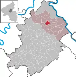 | |
 Leiningen  Leiningen | |
| Coordinates: 50°08′00″N 7°34′13″E | |
| Country | Germany |
| State | Rhineland-Palatinate |
| District | Rhein-Hunsrück-Kreis |
| Municipal assoc. | Hunsrück-Mittelrhein |
| Government | |
| • Mayor | Frank Morschhäuser |
| Area | |
| • Total | 5.75 km2 (2.22 sq mi) |
| Elevation | 448 m (1,470 ft) |
| Population (2019-12-31)[1] | |
| • Total | 703 |
| • Density | 120/km2 (320/sq mi) |
| Time zone | UTC+01:00 (CET) |
| • Summer (DST) | UTC+02:00 (CEST) |
| Postal codes | 56291 |
| Dialling codes | 06746 |
| Vehicle registration | SIM |
Geography
Location
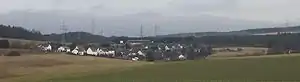
The municipality lies in the heights of the Vorderhunsrück (“Fore-Hunsrück”) roughly 15 km from the Rhine and the Moselle, and 30 km from Koblenz. The direct interchange onto the Autobahn A 61 affords a quick link to places to the north and south.
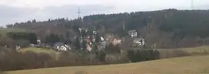
From here run a great many hiking trails and a direct link to the Schinderhannes-Radweg (cycle path); the outlying centre of Lamscheid lies right on this cycle path.
History
The Counts of Leyen at Gondorf were Leiningen’s lords in the Middle Ages. Beginning in 1794, Leiningen lay under French rule. In 1815 it was assigned to the Kingdom of Prussia at the Congress of Vienna. Since 1946, it has been part of the then newly founded state of Rhineland-Palatinate.
The current municipality came into being on 7 June 1969 under the name Leiningen-Lamscheid and was a merger of two hitherto self-administering municipalities that had been dissolved, called Leiningen and Lamscheid. On 1 January 1981, however, the name was shortened to Leiningen.[2]
Sauerbrunnen
This village’s history is closely bound with its namesake mineral spring – the name means “Sour Spring” or “Sour Well” – which had its first documentary mention in 1565. In 1780, this spring was set in stone as a token of thanks by Imperial Countess Marianne von der Leyen. About 1786, Sauerbrunnen was a spa centre and the water was sold abroad. By 1789, the well was falling into disrepair. In 1898, a housing was built to contain it, which was renovated in 1910, and on 11 June of that year, the spring was officially recognized as the Lamscheider Stahlbrunnen.
Politics
Municipal council
The council is made up of 12 council members, who were elected by majority vote at the municipal election held on 7 June 2009, and the honorary mayor as chairman.[3]
Mayor
Leiningen’s mayor is Frank Morschhäuser.[4]
Coat of arms
The German blazon reads: Über erhöhtem blauem Schildfuß, darin ein silberner Pfahl, in Silber ein schwarzer Schalenbrunnen mit geteiltem schwarzen Wasserstrahl, begleitet rechts und links von einem roten Krug.
The municipality’s arms might in English heraldic language be described thus: Per fess abased argent a fountain basin on a short pedestal sable issuant from which four streams of the same, two each falling into each of two two-handled jugs gules standing on each side of the basin, and azure a pale of the first aligned precisely with the pedestal.
The lower part of the escutcheon recalls the Counts of Leyen at Gondorf, to whom Leiningen once belonged. The charges above the line of partition refer to the sour spring – Sauerbrunnen – which was well known even as far back as the 16th century for its good mineral water. The jugs symbolize the former exportation of the springwater.[5]
Culture and sightseeing
Buildings
The following are listed buildings or sites in Rhineland-Palatinate’s Directory of Cultural Monuments:[6]
Leiningen (main centre)
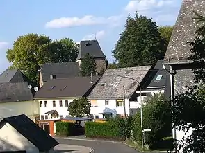
- Catholic Church of the Raising Aloft of Christ’s Cross (branch church; Filialkirche Kreuzerhöhung Christi), Kirchstraße – quire tower, late 13th or early 14th century, aisleless church, possibly from before 1400; whole complex of buildings with graveyard
- Hauptstraße 11 – estate complex along the street, timber framing, partly slated, stable and barn, 19th century, old yard paving stones; whole complex of buildings
- Marktplatz – Gothic Revival hand-pumped cast-iron well, Rheinböllen Ironworks, latter half of the 19th century
Sauerbrunnen
- Koblenzer Straße 8 – well housing; Baroque Revival plastered building, 1911, one-floor storage hall; whole complex of buildings
References
- "Bevölkerungsstand 2019, Kreise, Gemeinden, Verbandsgemeinden". Statistisches Landesamt Rheinland-Pfalz (in German). 2020.
- Statistisches Landesamt Rheinland-Pfalz - Amtliches Gemeindeverzeichnis 2006 Archived 2011-07-18 at the Wayback Machine, Seiten 185, 204
- Kommunalwahl Rheinland-Pfalz 2009, Gemeinderat
- Leiningen’s mayor
- Description and explanation of Leiningen’s arms
- Directory of Cultural Monuments in Rhein-Hunsrück district
External links
 Media related to Leiningen (Hunsrück) at Wikimedia Commons
| Authority control |
|---|