Lerderderg State Park
Lerderderg State Park (incorporating the former Pyrete State Forest) is a 14,250-hectare park located between Bacchus Marsh and Blackwood, an hour's drive from Melbourne, Australia.[1][2] There are several maintained tracks for walking through the park and camping is allowed.
| Lerderderg State Park Victoria | |
|---|---|
IUCN category II (national park) | |
 Lerderderg State Park | |
| Nearest town or city | Blackwood |
| Coordinates | 37°32′S 144°24′E |
| Area | 142.5 km2 (55.0 sq mi) |
| Managing authorities | Parks Victoria |
| Website | Lerderderg State Park |
| See also | Protected areas of Victoria |
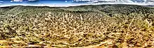
The park is named for the Lerderderg River which has cut the 300-metre-deep Lerderderg Gorge through sandstone and slate, almost bisecting the park.[3]
Parks Victoria maintains six designated walks: three short walks of 3.5 km or less; Blackwood-O'Briens Crossing and return (22 km); O'Briens Crossing-Cowan Track loop (14 km); and the overnight walk O'Briens Crossing to Mackenzies Flat (20 km).[1]
In addition, one leg of the Great Dividing Trail, the Lerderderg Track, passes through the park, entering from Blackwood in the park's northwest, and exiting south towards Bacchus Marsh.[4] Bicycles are prohibited from one section of this track, due to a conservation area.
References
- Lerderderg State Park, Parks Victoria, retrieved 29 January 2012
- Robin Taylor (1 January 1999), Wild Places of Greater Melbourne, CSIRO Publishing, p. 162, ISBN 978-0-9577471-0-4, retrieved 30 January 2012
- "Lerderderg State Park". Visit Melbourne. Tourism Victoria. Retrieved 25 July 2011.
- Lerderderg Track, Great Dividing Trail Association, retrieved 29 January 2012
| Wikimedia Commons has media related to Lerderderg State Park. |
See also
| Current |
| |
|---|---|---|
| Former |
| |