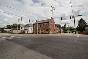
Lewisville, Indiana
Lewisville is a town in Franklin Township, Henry County, Indiana, United States. The population was 366 at the 2010 census. Lewisville's website is https://lewisvillein.net/
Lewisville, Indiana | |
|---|---|
 | |
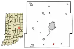 Location of Lewisville in Henry County, Indiana. | |
| Coordinates: 39°48′26″N 85°21′6″W | |
| Country | United States |
| State | Indiana |
| County | Henry |
| Township | Franklin |
| Area | |
| • Total | 0.26 sq mi (0.67 km2) |
| • Land | 0.26 sq mi (0.67 km2) |
| • Water | 0.00 sq mi (0.00 km2) |
| Elevation | 1,053 ft (321 m) |
| Population | |
| • Total | 366 |
| • Estimate (2019)[3] | 350 |
| • Density | 1,361.87/sq mi (526.17/km2) |
| Time zone | UTC-5 (Eastern (EST)) |
| • Summer (DST) | UTC-4 (EDT) |
| ZIP code | 47352 |
| Area code(s) | 765 |
| FIPS code | 18-43074[4] |
| GNIS feature ID | 0437809[5] |
History
Lewisville was platted in 1829, and named for Lewis C. Freeman one of its founders and afterward first postmaster.[6] A post office has been in operation in Lewisville since 1831.[7] In 1833 (when there was considerable inconsistency in the spelling of Indiana place names), it was described as follows: 'Louisville, a village in Henry county, on the National Road [U.S. 40], on the east bank of Flatrock, about ten miles south of Newcastle. It contains a small population, and one store; but has a prospect of rapid increase.' [8] By 1909, it had a population of 503, more than 2 dozen businesses, two doctors, a newspaper, and a railway station.[9]
Guyer Opera House was added to the National Register of Historic Places in 1979.[10]
Geography
Lewisville is located at 39°48′26″N 85°21′6″W (39.807221, -85.351549),[11] along the Flatrock River.[12]
According to the 2010 census, Lewisville has a total area of 0.25 square miles (0.65 km2), all land.[13]
Demographics
| Historical population | |||
|---|---|---|---|
| Census | Pop. | %± | |
| 1850 | 193 | — | |
| 1870 | 416 | — | |
| 1880 | 446 | 7.2% | |
| 1890 | 420 | −5.8% | |
| 1900 | 404 | −3.8% | |
| 1910 | 446 | 10.4% | |
| 1920 | 460 | 3.1% | |
| 1930 | 442 | −3.9% | |
| 1940 | 531 | 20.1% | |
| 1950 | 591 | 11.3% | |
| 1960 | 592 | 0.2% | |
| 1970 | 530 | −10.5% | |
| 1980 | 577 | 8.9% | |
| 1990 | 437 | −24.3% | |
| 2000 | 395 | −9.6% | |
| 2010 | 366 | −7.3% | |
| 2019 (est.) | 350 | [3] | −4.4% |
| U.S. Decennial Census[14] | |||
2010 census
As of the census[2] of 2010, there were 366 people, 145 households, and 104 families living in the town. The population density was 1,464.0 inhabitants per square mile (565.3/km2). There were 164 housing units at an average density of 656.0 per square mile (253.3/km2). The racial makeup of the town was 99.5% White and 0.5% from two or more races. Hispanic or Latino of any race were 1.4% of the population.
There were 145 households, of which 29.0% had children under the age of 18 living with them, 56.6% were married couples living together, 11.7% had a female householder with no husband present, 3.4% had a male householder with no wife present, and 28.3% were non-families. 25.5% of all households were made up of individuals, and 13.8% had someone living alone who was 65 years of age or older. The average household size was 2.52 and the average family size was 2.95.
The median age in the town was 42.4 years. 20.5% of residents were under the age of 18; 9.5% were between the ages of 18 and 24; 24.3% were from 25 to 44; 27.8% were from 45 to 64; and 17.8% were 65 years of age or older. The gender makeup of the town was 46.7% male and 53.3% female.
2000 census
As of the census[4] of 2000, there were 395 people, 151 households, and 117 families living in the town. The population density was 1,206.4 people per square mile (462.2/km2). There were 157 housing units at an average density of 479.5 per square mile (185.1/km2). The racial makeup of the town was 99.24% White, and 0.76% from two or more races.
There were 151 households, out of which 33.1% had children under the age of 18 living with them, 66.9% were married couples living together, 7.3% had a female householder with no husband present, and 21.9% were non-families. 19.2% of all households were made up of individuals, and 11.9% had someone living alone who was 65 years of age or older. The average household size was 2.62 and the average family size was 2.97.
In the town, the population was spread out, with 23.8% under the age of 18, 10.4% from 18 to 24, 25.8% from 25 to 44, 21.5% from 45 to 64, and 18.5% who were 65 years of age or older. The median age was 39 years. For every 100 females, there were 94.6 males. For every 100 females age 18 and over, there were 90.5 males.
The median household income of the town was $37,841, and the median family income was $43,750. Males had a median income of $34,750, versus $23,864 for females. The per capita income for the town was $15,476. About 4.5% of families and 8.3% of the population were below the poverty line, including 12.1% of those under age 18 and none of those age 65 or over.
References
- "2019 U.S. Gazetteer Files". United States Census Bureau. Retrieved July 16, 2020.
- "U.S. Census website". United States Census Bureau. Retrieved 2012-12-11.
- "Population and Housing Unit Estimates". United States Census Bureau. May 24, 2020. Retrieved May 27, 2020.
- "U.S. Census website". United States Census Bureau. Retrieved 2008-01-31.
- "US Board on Geographic Names". United States Geological Survey. 2007-10-25. Retrieved 2008-01-31.
- Hazzard, George (1906). Hazzard's History of Henry County, Indiana, 1822-1906. G. Hazzard, author and publisher. pp. 937–938.
- "Henry County". Jim Forte Postal History. Retrieved 2 February 2015.
- 'Louisville.' In John Scott, The Indiana Gazetteer, or Topographical Dictionary; containing a description of the several counties, towns, villages, settlements, roads, lakes, rivers, creeks, and springs, in the State of Indiana, 2nd ed., carefully revised, corrected, and enlarged (Indianapolis: Douglass and Maguire, 1833), pp. 109-110.
- Complete Directory of Henry County, Indiana, comprising A List of all Residents of the Cities and Towns, together with an accurate rural list, giving number of acres owned, title, section numbers and rural routes (Portland, Indiana: J. M. Minch, 1909), pp. 11 and 195.
- "National Register Information System". National Register of Historic Places. National Park Service. July 9, 2010.
- "US Gazetteer files: 2010, 2000, and 1990". United States Census Bureau. 2011-02-12. Retrieved 2011-04-23.
- DeLorme (1998). Indiana Atlas & Gazetteer. Yarmouth, Maine: DeLorme. ISBN 0-89933-211-0
- "G001 - Geographic Identifiers - 2010 Census Summary File 1". United States Census Bureau. Archived from the original on 2020-02-13. Retrieved 2015-07-17.
- "Census of Population and Housing". Census.gov. Retrieved June 4, 2015.
Municipalities and communities of Henry County, Indiana, United States | ||
|---|---|---|
| City | Map of Indiana highlighting Henry County | |
| Towns | ||
| Townships | ||
| Unincorporated communities | ||
| Footnotes | ‡This populated place also has portions in an adjacent county or counties | |
| ||