Lincoln Regional Airport (California)
Lincoln Regional Airport (ICAO: KLHM, FAA LID: LHM, formerly O51) (Karl Harder Field) is a public airport three miles (5 km) west of Lincoln, in Placer County, California. It is owned by the City of Lincoln.[1]
Lincoln Regional Airport Karl Harder Field Lincoln Air Force Auxiliary Field | |||||||||||
|---|---|---|---|---|---|---|---|---|---|---|---|
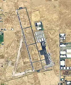 2006 USGS photo | |||||||||||
| Summary | |||||||||||
| Airport type | Public | ||||||||||
| Owner | City of Lincoln | ||||||||||
| Location | Lincoln, California | ||||||||||
| Elevation AMSL | 121 ft / 37 m | ||||||||||
| Coordinates | 38°54′33″N 121°21′05″W | ||||||||||
| Map | |||||||||||
 KLHM | |||||||||||
| Runways | |||||||||||
| |||||||||||
| Statistics (1993) | |||||||||||
| |||||||||||
Most U.S. airports use the same three-letter location identifier for the Federal Aviation Administration and International Air Transport Association, but Lincoln Regional Airport is LHM to the FAA and has no IATA code.
Facilities
The Lincoln Regional airport covers 725 acres (293 ha); its one runway (15/33) is 6,001 x 100 ft (1,829 x 30 m) asphalt.[1]
In the year ending June 10, 1993, the airport had 71,000 aircraft operations, average 194 per day: 96% general aviation and 4% air taxi. 207 aircraft are based at the airport: 92% single engine, 7% multi-engine, 1% jet and <1% helicopters.[1]
World War II
During World War II, the airport was Lincoln Air Force Auxiliary Field and was an auxiliary training airfield for Mather Army Airfield, California.
References
![]() This article incorporates public domain material from the Air Force Historical Research Agency website http://www.afhra.af.mil/.
This article incorporates public domain material from the Air Force Historical Research Agency website http://www.afhra.af.mil/.
- FAA Airport Form 5010 for LHM PDF, effective 2007-07-05
External links
- Resources for this airport:
- FAA airport information for LHM
- AirNav airport information for LHM
- FlightAware airport information and live flight tracker
- SkyVector aeronautical chart for LHM
| Flying Training |
|  | ||||
|---|---|---|---|---|---|---|
| Technical Training |
| |||||