List of Natural Monuments of Japan (Hokkaidō)
National Natural Monuments
As of 1 October 2016, forty-seven Natural Monuments have been designated, including six *Special Natural Monuments.[2][3][4][5]
| Monument | Municipality | Comments | Image | Coordinates | Type | Ref. |
|---|---|---|---|---|---|---|
| *Mount Apoi alpine plant communities アポイ岳高山植物群落 Apoi-dake kōzan shokubutsu gunraku | Samani | 42°06′50″N 143°01′55″E | 1.3 | |||
| *Marimo of Lake Akan Aegagropila linnaei 阿寒湖のマリモ Akan-ko no marimo | Akan | 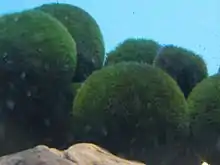 | 43°27′12″N 144°06′08″E | 2.8, 12 | ||
| *Shōwa-shinzan 昭和新山 Shōwa-shinzan | Sōbetsu | 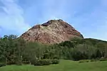 | 42°32′33″N 140°51′52″E | 3.10 | ||
| *Daisetsuzan 大雪山 Daisetsuzan | Kamikawa, Higashikawa, Biei, Shintoku | 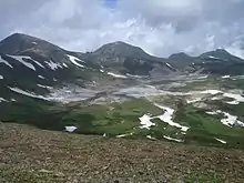 | 43°33′04″N 142°49′48″E | 4 | ||
| *Nopporo Forest Park 野幌原始林 Nopporo genshi-rin | Kitahiroshima | .jpg.webp) | 42°59′28″N 141°32′01″E | 2.2 | ||
| *Japanese crane Grus japonensis タンチョウ Tanchō | 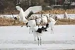 | 1.2 | ||||
| Hokkaido Canis lupus familiaris 北海道犬 Hokkaidō-ken | 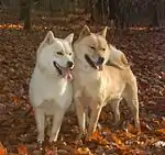 | 1.4 | ||||
| Golden eagle Aquila chrysaetos イヌワシ Inu-washi | .jpg.webp) | 1.2 | ||||
| White-tailed eagle Haliaeetus albicilla オジロワシ Ojiro-washi | .jpg.webp) | 1.2 | ||||
| Steller's sea eagle Haliaeetus pelagicus オオワシ Ō-washi |  | 1.2 | ||||
| Blakiston's fish owl Bubo blakistoni blakistoni エゾシマフクロウ Ezo-shimafukurō | 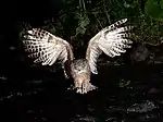 | 1.1 | ||||
| Brent goose Branta bernicla コクガン Kokugan |  | 1.2 | ||||
| Greater white-fronted goose Anser albifrons マガン Magan | 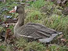 | 1.2 | ||||
| Bean goose Anser fabalis ヒシクイ Hishikui | 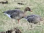 | 1.2 | ||||
| Black woodpecker Dryocopus martius クマゲラ Kumagera | .jpg.webp) | 1.2 | ||||
| Eversmann's parnassian Parnassius eversmanni ウスバキチョウ Usubaki-chō | 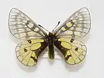 | 1.2 | ||||
| Melissa Arctic Oeneis melissa daizetsuzana ダイセツタカネヒカゲ Daisetsu-takanehikage | 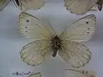 | 1.2 | ||||
| Freija fritillary Clossiana freija アサヒヒョウモン Asahi-hyōmon | 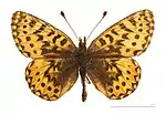 | 1.2 | ||||
| Grizzled skipper Pyrgus malvae ヒメチャマダラセセリ Hime-chamadara-seseri | .jpg.webp) | 1.2 | ||||
| Sakhalin holly blue Celastrina sachalinensis カラフトルリシジミ Karafuto-rurishijimi | 1.2 | |||||
| Yezosaurus fossil Taniwhasaurus mikasaensis エゾミカサリュウ化石 Ezo Mikasa Ryū kaseki | Mikasa | kept at Mikasa City Museum | 43°15′41″N 141°57′46″E | 3.12 | ||
| Breeding grounds of the streaked shearwater Calonectris leucomelas オオミズナギドリ繁殖地 Ōmizunagidori hanshokuchi | Matsumae | on Ōshima | 41°30′42″N 139°21′26″E | 1.2 | ||
| Onnetō Hot Falls manganese oxide generation area オンネトー湯の滝マンガン酸化物生成地 Onnetō yu-no-taki mangan sankabutsu seiseichi | Ashoro | 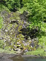 | 43°22′13″N 143°58′39″E | 2.8; 3.1, 8 | ||
| Thujopsis and Sakhalin fir habitat Thujopsis dolabrata var. hondae Abies sachalinensis var. mayriana ヒノキアスナロおよびアオトドマツ自生地 Hinoki-asunaro oyobi ao-todomatsu jiseichi | Esashi |  | 41°49′11″N 140°12′31″E | 2.2, 10 | ||
| Maruyama primeval forest 円山原始林 Maruyama genshi-rin | Sapporo | 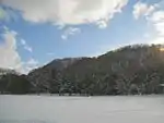 | 43°02′54″N 141°18′50″E | 2.2 | ||
| Utasai northernmost limit of the Japanese beech Fagus crenata 歌才ブナ自生北限地帯 Utasai buna jisei hokugen chitai | Kuromatsunai | 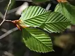 | 42°38′46″N 140°19′48″E | 2.10 | ||
| Kushiro-shitsugen 釧路湿原 Kushiro-shitsugen | Shibecha, Tsurui, Kushiro | see Kushiro-shitsugen National Park, List of Ramsar sites in Japan | 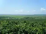 | 43°07′45″N 144°25′20″E | 4 | |
| Mount Shiribeshi alpine plant zone 後方羊蹄山の高山植物帯 Shiribeshi-yama no kōzan shokubutsu tai | Kutchan, Kyōgoku, Kimobetsu, Makkari, Niseko | 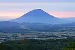 | 42°49′49″N 140°47′37″E | 2.3 | ||
| Nemuro Kuruma-ishi 根室車石 Nemuro Kuruma-ishi | Nemuro | 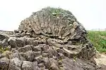 | 43°16′41″N 145°35′20″E | 3.7 | ||
| Primeval forest by the headwaters of the Saru River 沙流川源流原始林 Sarugawa-genryū genshi-rin | Hidaka | 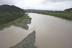 | 42°58′58″N 142°44′45″E | 4 | ||
| Lake Harutori common goldfish habitat Carassius auratus 春採湖ヒブナ生息地 Harutori-ko hibuna seisokuchi | Kushiro |  | 42°58′20″N 144°24′13″E | 1.3 | ||
| Memanbetsu wetland plant communities 女満別湿生植物群落 Memanbetsu shitsusei shokubutsu gunraku | Ōzora | 43°56′05″N 144°10′48″E | 2.2 | |||
| Kojima, Matsumae 松前小島 Matsumae Kojima | Matsumae | 41°21′35″N 139°48′20″E | 4 | |||
| Natural forests of Yagishiri 焼尻の自然林 Yagishiri no shinzen-rin | Haboro | 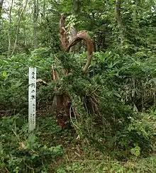 | 44°26′21″N 141°25′12″E | 2.2 | ||
| Moiwa primeval forest 藻岩原始林 Moiwa genshi-rin | Sapporo | 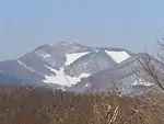 | 43°01′36″N 141°19′33″E | 2.2 | ||
| Daikoku Island seabird breeding grounds 大黒島海鳥繁殖地 Daikoku-jima kaichō hanshokuchi | Akkeshi | 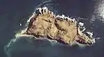 | 42°57′01″N 144°52′09″E | 1.2 | ||
| Teuri Island seabird breeding grounds 天売島海鳥繁殖地 Teuri-tō kaichō hanshokuchi | Haboro |  | 44°25′09″N 141°17′41″E | 1.2 | ||
| Noboribetsu primeval forest 登別原始林 Noboribetsu genshi-rin | Noboribetsu | 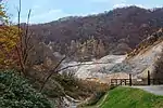 | 42°29′45″N 141°09′15″E | 2.2 | ||
| Shibetsu Marsh 標津湿原 Shibetsu-shitsugen | Shibetsu | 43°40′34″N 145°06′36″E | 4 | |||
| Horoman Japanese white pine habitat Pinus parviflora 幌満ゴヨウマツ自生地 Horoman goyōmatsu jiseichi | Samani | 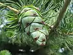 | 42°06′00″N 143°03′32″E | 2.2 | ||
| Kiritappu peat-forming plant communities 霧多布泥炭形成植物群落 Kiritappu deitan keisei shokubutsu gunraku | Hamanaka | 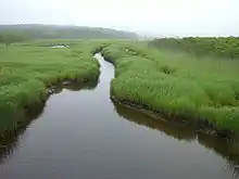 | 43°05′38″N 145°04′48″E | 2.6 | ||
| Nayoro loess dolls 名寄高師小僧 Nayoro takashi kozō | Nayoro | 44°22′05″N 142°22′50″E | 3.1, 4 | |||
| Nayoro bell stone 名寄鈴石 Nayoro suzu-ishi | Nayoro | 44°19′45″N 142°28′42″E | 3.1, 7 | |||
| Mount Yūbari alpine plant communities and serpentinite mélange zone 夕張岳の高山植物群落および蛇紋岩メランジュ帯 Yūbari-dake no kōzan shokubutsu gunraku oyobi jamon-gan meranju-tai | Yūbari | 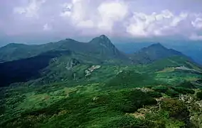 | 43°06′11″N 142°14′12″E | 2.2, 3 | ||
| Cape Ochiishi Sakai rhododendron habitat Rhododendron parvifolium 落石岬のサカイツツジ自生地 Ochiishi-misaki no sakai-tsutsuji jiseichi | Nemuro | 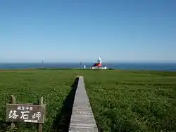 | 43°09′54″N 145°30′23″E | 2.10 | ||
| Wakoto Minminzemi zone Hyalessa maculaticollis 和琴ミンミンゼミ発生地 Wakoto minminzemi hassei-chi | Teshikaga | 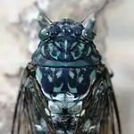 | 43°35′02″N 144°18′47″E | 1.2 | ||
| River Uzura northernmost native limit of the Japanese white pine Pinus parviflora 鶉川ゴヨウマツ自生北限地帯 Uzura-gawa goyōmatsu jisei hokugen chitai | Assabu | 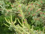 | 41°59′25″N 140°25′34″E | 2.10 | ||
Prefectural Natural Monuments
As of 21 September 2016, thirty-three Natural Monuments have been designated at a prefectural level.[4][6][7]
| Monument | Municipality | Comments | Image | Coordinates | Type | Ref. |
|---|---|---|---|---|---|---|
| Kayabe Chestnut Forest Castanea crenata 茅部の栗林 Kayabe no kuri-bayashi | Mori |  | 42°06′13″N 140°34′35″E | |||
| Calcareous sinter of Futamata Onsen 二股温泉の石灰華 Futamata Onsen no sekkaika | Oshamambe | 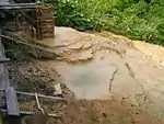 | 42°34′36″N 140°14′22″E | |||
| Andesite columnar jointing of Cape Shibi, Otobe 乙部鮪ノ岬の安山岩柱状節理 Otobe Shibi-no-misaki no anzangan chūjō setsuri | Otobe | 42°02′12″N 140°04′58″E | ||||
| Japanese yew of Kogane Taxus cuspidata 黄金水松 Kogane mizumatsu | Ashibetsu |  | 43°35′25″N 142°13′14″E | |||
| Potholes of Sorachi Ōtaki 空知大滝甌穴群 Sorachi ōtaki ōketsugun | Ashibetsu | 43°26′24″N 142°16′58″E | ||||
| Uryū-numa high moor belt 雨竜沼高層湿原帯 Uryū-numa kōsō shitsugen-tai | Uryū | see Shokanbetsu-Teuri-Yagishiri Quasi-National Park, List of Ramsar sites in Japan | 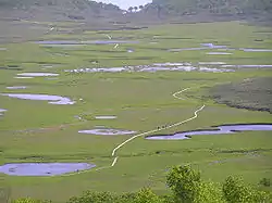 | 43°41′48″N 141°36′14″E | ||
| Fossil type specimen of the Takikawa sea cow タキカワカイギュウ化石標本 Takikawa-kaigyū kaseki hyōhon | Takikawa | kept at the Takikawa Museum of Art and Natural History | 43°33′07″N 141°54′53″E | |||
| Large outcrop of coal at Yūbari 夕張の石炭大露頭 Yūbari no sekitan dai-rotō | Yūbari | see Yūbari Coal Mine Museum | 43°04′06″N 141°59′22″E | |||
| Tōma Limestone Cave 当麻鍾乳洞 Tōma shōnyūdō | Tōma | discovered in 1957; five main chambers stretch a total length of 135 metres | 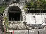 | 43°49′33″N 142°36′35″E | ||
| Nakatonbetsu Limestone Cave 中頓別鍾乳洞 Nakatonbetsu shōnyūdō | Nakatonbetsu | discovered in 1933 | 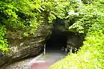 | 44°59′17″N 142°20′09″E | ||
| Wakasakanai coastal dune forest 稚咲内海岸砂丘林 Wakasakanai kaigan sakyū-rin | Toyotomi | a twenty kilometre stretch of forest bordering the Sarobetsu plain and some one hundred lakes; tree species include the Yezo spruce, Japanese emperor oak, Mongolian oak, painted maple, prickly castor oil tree, and Japanese lime; the Siberian rubythroat, yellow-breasted bunting, Japanese snipe, smew, Japanese robin, and willow tit may be found within the Wildlife Protection Area | 45°05′17″N 141°38′31″E | |||
| Rishiri Island Kurile cherry habitat Prunus nipponica var. kurilensis 利尻島のチシマザクラ自生地 Rishiri-tō no chishima-zakura jiseichi | Rishiri | 45°07′35″N 141°15′02″E | ||||
| Wild plants around Momo-iwa, Rebun Island 礼文島桃岩付近一帯の野生植物 Rebun-tō Momo-iwa fukin ittai no yasei shokubutsu | Rebun | 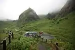 | 45°17′46″N 141°01′54″E | |||
| Natural habitat of the Rebun lady's slipper orchid Cypripedium macranthum var. rebunense レブンアツモリソウ群生地 Rebun atsumorisō-gun seichi | Rebun | 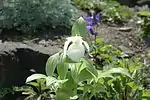 | 45°25′33″N 141°00′11″E | |||
| Rhyolitic spherulites at Shirataki 白滝の流紋岩球顆 Shirataki no ryūmongan kyūka | Engaru | 43°53′12″N 143°11′34″E | ||||
| Grassland communities of the Shari coast 斜里海岸の草原群落 Shari-kaigan no sōgen gunraku | Shari | the grasslands stretch for 2.5 km to the west of the Shari River (斜里川) | 43°55′02″N 144°34′04″E | |||
| Oshunkoshun dolerite columnar joints オシュンコシュン粗粒玄武岩柱状節理 Oshunkoshun soryū genbugan chūjō setsuri | Shari | 44°02′17″N 144°56′06″E | ||||
| Glasswort communities of Tsuru-numa beside Lake Saroma Salicornia europaea 佐呂間湖畔鶴沼のアッケシソウ群落 Saroma kohan Tsuru-numa no akkeshisō gunraku | Yūbetsu | 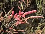 | 44°07′58″N 143°50′17″E | |||
| Onneyu Rhododendron dauricum communities Rhododendron dauricum 温根湯エゾムラサキツツジ群落 Onneyu Ezo murasaki-tsutsuji gunraku | Kitami | 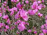 | 43°45′35″N 143°30′57″E | |||
| Mount Tarumae lava dome 樽前山熔岩円頂丘 Tarumae-san yōgan enchōkyū | Tomakomai | 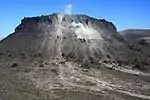 | 42°41′24″N 141°22′34″E | |||
| Niikappu mud volcano 新冠泥火山 Niikappu deikazan | Niikappu |  | 42°22′28″N 142°18′36″E | |||
| Betula ovalifolia of Sarabetsu Marsh Betula ovalifolia 更別湿原のヤチカンバ Sarabetsu-shitsugen no yachikanba | Sarabetsu | 42°35′47″N 143°13′52″E | ||||
| Lake Shikaribetsu Dolly Varden trout habitat Salvelinus malma 然別湖のオショロコマ生息地 Shikaribetsu-ko no oshorokoma seisokuchi | Shikaoi, Kamishihoro | 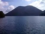 | 43°16′31″N 143°06′56″E | |||
| Satsunai River basin Chosenia habitat Salix arbutifolia 札内川流域化粧柳自生地 Satsunai-gawa ryūiki keshō-yanagi jiseichi | Obihiro | 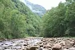 | 42°35′47″N 143°13′52″E | |||
| Taishō Japanese emperor oak forest Quercus dentata 大正のカシワ林 Taishō no kashiwa-rin | Obihiro |  | 42°48′09″N 143°10′17″E | |||
| "Tokachi-bōzu" patterned ground on the Obihiro University of Agriculture and Veterinary Medicine farm Quercus dentata 帯広畜産大学農場の構造土十勝坊主 Obihiro Chikusan Daigaku nōjō no kōzōdo Tokachi-bōzu | Obihiro | 42°51′59″N 143°10′14″E | ||||
| Ōtsu coast Toitokki beach wild plant communities 大津海岸トイトツキ浜野生植物群落 Ōtsu-kaigan Toitokki-hama yasei shokubutsu gunraku | Toyokoro | 42°42′11″N 143°39′49″E | ||||
| Ōtsu coast Chōbushi lakeside wild plant communities 大津海岸長節湖畔野生植物群落 Ōtsu-kaigan Chōbushi kohan yasei shokubutsu gunraku | Toyokoro | 42°39′35″N 143°36′38″E | ||||
| Akkeshi Tokotan-numa Common goldfish habitat Carassius auratus 厚岸床潭沼の緋鮒生息地 Akkeshi Tokotan-numa no hibuna seisokuchi | Akkeshi | 43°00′11″N 144°52′05″E | ||||
| Yururi and Moyururi Island seabird breeding grounds ユルリ・モユルリ島海鳥繁殖地 Yururi・Moyururi-tō kaichō hanshokuchi | Nemuro | 43°13′37″N 145°36′27″E | ||||
| Betula ovalifolia communities of Nishibetsu Marsh Betula ovalifolia 西別湿原ヤチカンバ群落地 Nishibetsu-shitsugen yachikanba gunraku-chi | Betsukai | 43°23′36″N 145°06′45″E | ||||
| Rausu luminous moss Schistostega pennata 羅臼のひかりごけ Rausu no hikarigoke | Rausu | 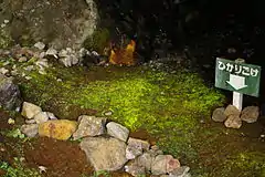 | 44°01′21″N 145°11′55″E | |||
| Rausu geyser 羅臼の間歇泉 Rausu no kanketsusen | Rausu | 44°02′01″N 145°09′34″E | ||||
Municipal Natural Monuments
As of 1 May 2016, one hundred and twenty-nine Natural Monuments have been designated at a municipal level.[8][9]
| Monument | Municipality | Comments | Image | Coordinates | Type | Ref. |
|---|---|---|---|---|---|---|
| Ammonite fossils Ammonoidea アンモナイト化石(4点) Anmonaito kaseki (4-ten) | Mikasa | four fossils; kept at Mikasa City Museum | 43°15′41″N 141°57′46″E | for all refs see | ||
| Ammonite fossil Ammonoidea アンモナイト化石 Anmonaito kaseki | Mikasa | kept at Mikasa City Museum | 43°15′41″N 141°57′46″E | |||
| Mammoth molar fossil Mammuthus マンモスゾウ臼歯化石 Manmosu-zō kyūshi kaseki | Yuni | kept at Yumekukan (ゆめっく館) | 43°00′37″N 141°46′56″E | |||
| Mammoth molar fossil Mammuthus マンモスゾウ臼歯化石 Manmosu-zō kyūshi kaseki | Yuni | kept at Yumekukan (ゆめっく館) | 43°00′37″N 141°46′56″E | |||
| Megaloceros fossil Megaloceros オオツノシカ化石 Ōtsuno-shika kaseki | Yuni | kept at Yumekukan (ゆめっく館) | 43°00′37″N 141°46′56″E | |||
| Bison fossil Bison バイソン(Bison.sp)の化石 Baison no kaseki | Kitahiroshima | kept at Kitahiroshima East Memorial Hall (北広島東記念館) | 42°59′15″N 141°34′23″E | |||
| Gome Island, Otoshibe 音標のゴメ島 Otoshibe no Gome-jima | Esashi | 44°42′03″N 142°49′54″E | ||||
| Ezo salamander habitat Hynobius retardatus エゾサンショーウオ生息地 Ezo sanshōō seisokuchi | Esashi | 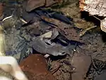 | 45°01′51″N 142°30′35″E | |||
| Siberian salamander Salamandrella keyserlingii キタサンショウウオ Kita-sanshōō | Shibecha | |||||
| Tangible Cultural Properties |    | |
|---|---|---|
| Intangible Cultural Properties |
| |
| Folk Cultural Properties |
| |
| Monuments |
| |
| Cultural Landscapes | Cultural Landscape along the Saru River resulting from Ainu Tradition and Modern Settlement | |
| Groups of Traditional Buildings |
| |
| Conservation Techniques | N/A | |
1 | ||
See also
- Cultural Properties of Japan
- List of parks and gardens of Hokkaido
- List of Places of Scenic Beauty of Japan (Hokkaido)
- List of Natural Monuments of Japan (Okinawa)
References
- "Cultural Properties for Future Generations". Agency for Cultural Affairs. Retrieved 4 October 2016.
- 史跡名勝天然記念物 [Number of Monuments of Japan by Prefecture] (in Japanese). Agency for Cultural Affairs. 1 October 2016. Retrieved 4 October 2016.
- "Database of National Cultural Properties: 史跡名勝天然記念物 (特別天然記念物, 天然記念物 北海道)" (in Japanese). Agency for Cultural Affairs. Archived from the original on 2 May 2017. Retrieved 4 October 2016.
- 北海道の指定文化財件数一覧 [Number of Cultural Properties of Hokkaido] (in Japanese). Hokkaido Government Board of Education. 17 August 2016. Retrieved 4 October 2016.
- 国の指定・選定文化財一覧 [List of National Cultural Properties] (in Japanese). Hokkaido Government Board of Education. 29 August 2016. Retrieved 4 October 2016.
- 都道府県別指定等文化財件数(都道府県分) [Number of Prefectural Cultural Properties by Prefecture] (in Japanese). Agency for Cultural Affairs. 1 May 2016. Retrieved 4 October 2016.
- 北海道指定の文化財一覧 [List of Hokkaido Prefectural Cultural Properties] (in Japanese). Hokkaido Government Board of Education. 21 September 2016. Retrieved 4 October 2016.
- 都道府県別指定等文化財件数(市町村分) [Number of Municipal Cultural Properties by Prefecture] (in Japanese). Agency for Cultural Affairs. 1 May 2016. Retrieved 4 October 2016.
- 市町村指定文化財一覧 [List of Municipal Cultural Properties] (in Japanese). Hokkaido Government Board of Education. 1 May 2016. Retrieved 4 October 2016.
External links
- (in Japanese) Cultural Properties in Hokkaido
This article is issued from Wikipedia. The text is licensed under Creative Commons - Attribution - Sharealike. Additional terms may apply for the media files.